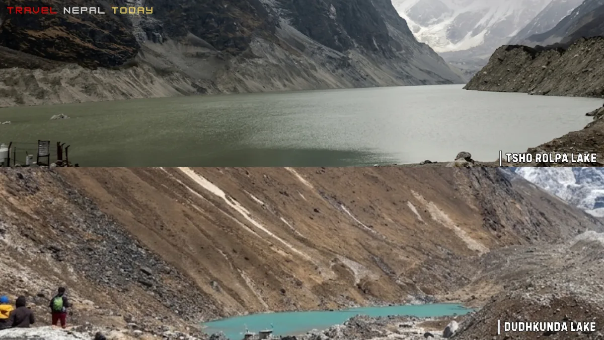
The Tsho Rolpa Lake Trek takes you deep into the Rolwaling Valley of Dolakha, one of Nepal’s most underrated and least-crowded trekking regions. Tsho Rolpa, sitting at roughly 4,580 m, is the largest moraine-dammed proglacial lake in the Nepalese Himalayas, formed rapidly over recent decades due to the retreat of the Trakarding Glacier above it. Beyond the main lake lies Dudhkunda (Dudh Pokhari), a smaller hidden alpine glacial pond above 4,700 m that most trekkers surprisingly skip despite its dramatic setting and views.
What You’ll Find in This Tsho Rolpa Lake Trek Guide:
- Complete overview of the Tsho Rolpa and Dudhkunda Trek inside the Rolwaling Valley of Dolakha within the Gaurishankar Conservation Area (GCA)
- Why Tsho Rolpa is one of Nepal’s most fascinating glacial lakes: moraine-dammed formation, rapid glacier retreat, high-altitude setting, and remote Himalayan scenery
- Detailed trail breakdown from Chetchet to Tsho Rolpa with altitudes, distances, walking hours, elevation gain, and trail conditions
- Three itinerary options: 5-day short trek, 6-day recommended trek, and 7-day relaxed trek with complete day-by-day tables
- How to reach Chetchet from Kathmandu via local bus or jeep, including current road realities
- An honest difficulty breakdown covering altitude, steep ascents, long walking days, and common mistakes trekkers make
- Best time to visit with a detailed comparison of all six Nepali seasons and changing mountain weather patterns
- Permit requirements including the Gaurishankar Conservation Area Permit and Restricted Area Permit (RAP)
- Food, drinking water, and accommodation details from Chetchet all the way to Na village and Tsho Rolpa
- A realistic packing list based on personal trekking experience, including gear mistakes I personally made on the trail
- The Sherpa villages of Rolwaling Valley, local culture, monasteries, and daily life in Beding and Na
- Rolwaling Valley Yeti legends and why this region is deeply tied to Himalayan folklore
- Wildlife, alpine landscapes, glaciers, rivers, and mountain views found throughout the trail
- Cost breakdown for Nepali and foreign trekkers including transport, permits, food, and accommodation
- Important trekking tips, acclimatization advice, and responsible trekking practices for the Rolwaling Valley
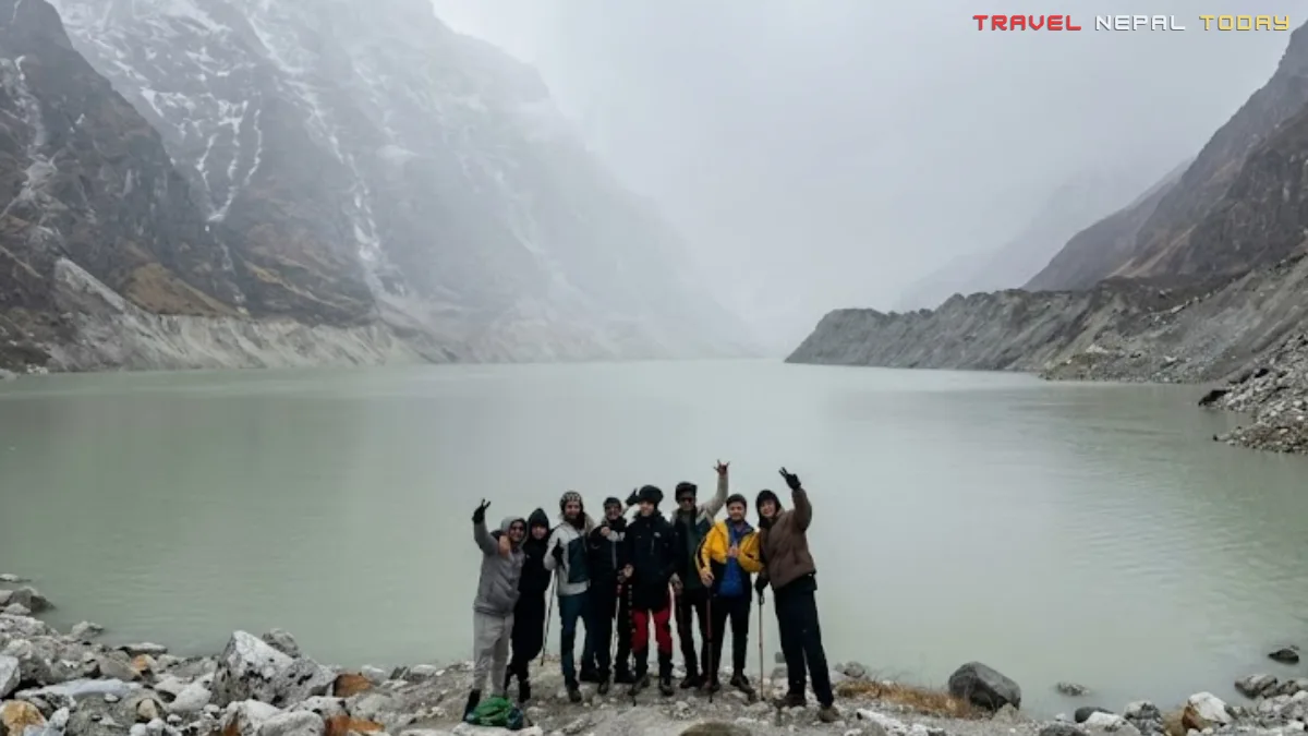
I still remember what I felt stepping off that bumpy bus at Chetchet in April 2022. It was going to be my very first high-altitude trek.
Our group of eight had no professional guide for the upper section and just a general idea of the route. We were young, a little reckless, and completely unprepared for what was ahead!
What hit me first was the silence of the Rolwaling Valley. No crowds, no signboards crowded with agency advertisements, no trekkers queuing at a teahouse. Just forest, river sounds, and mountains getting bigger with every step!
By the time we reached Naa village at 4,180 m, things had changed completely. We were sitting in a mountaineer’s hotel, the family around us having collectively summited Everest more times than I had done any trek.
And over cups of hot butter tea, they talked about the Yeti as if it were a neighbor who had simply moved to a higher ridge. Not a ghost story, not a tourist gimmick. Just part of the valley’s daily reality!
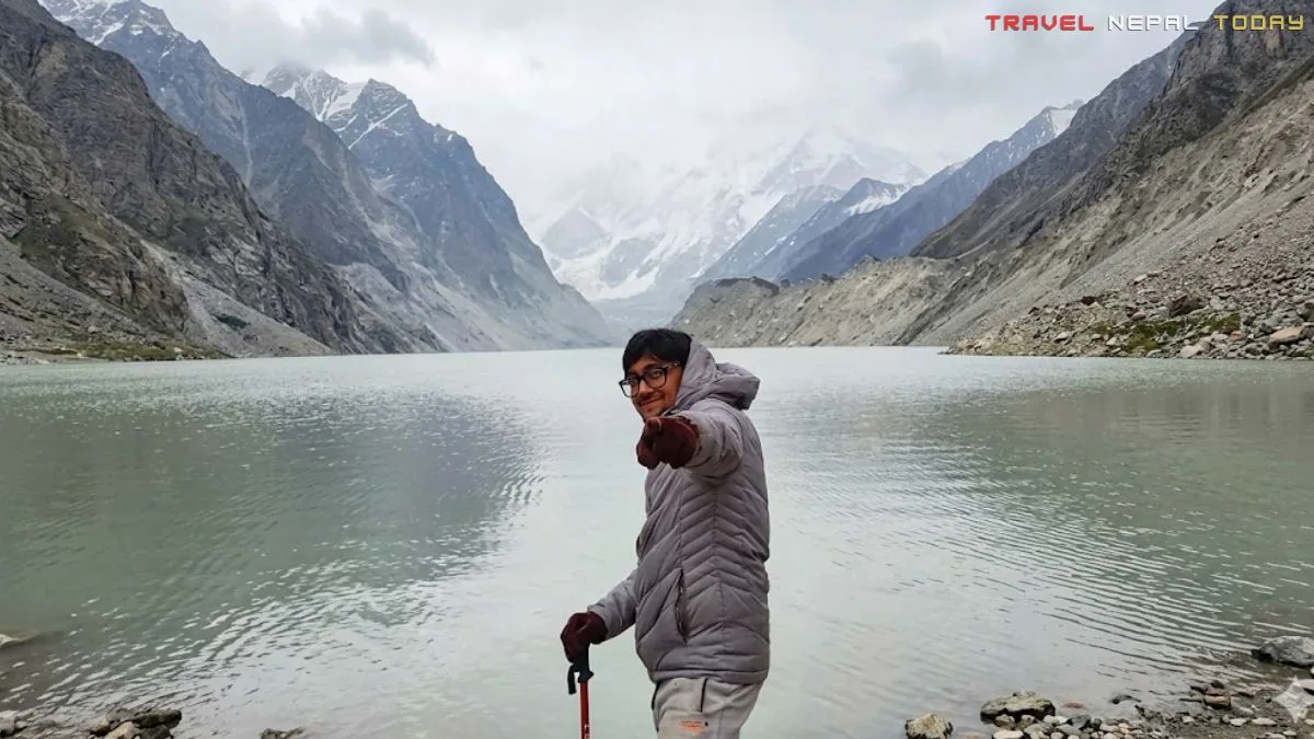
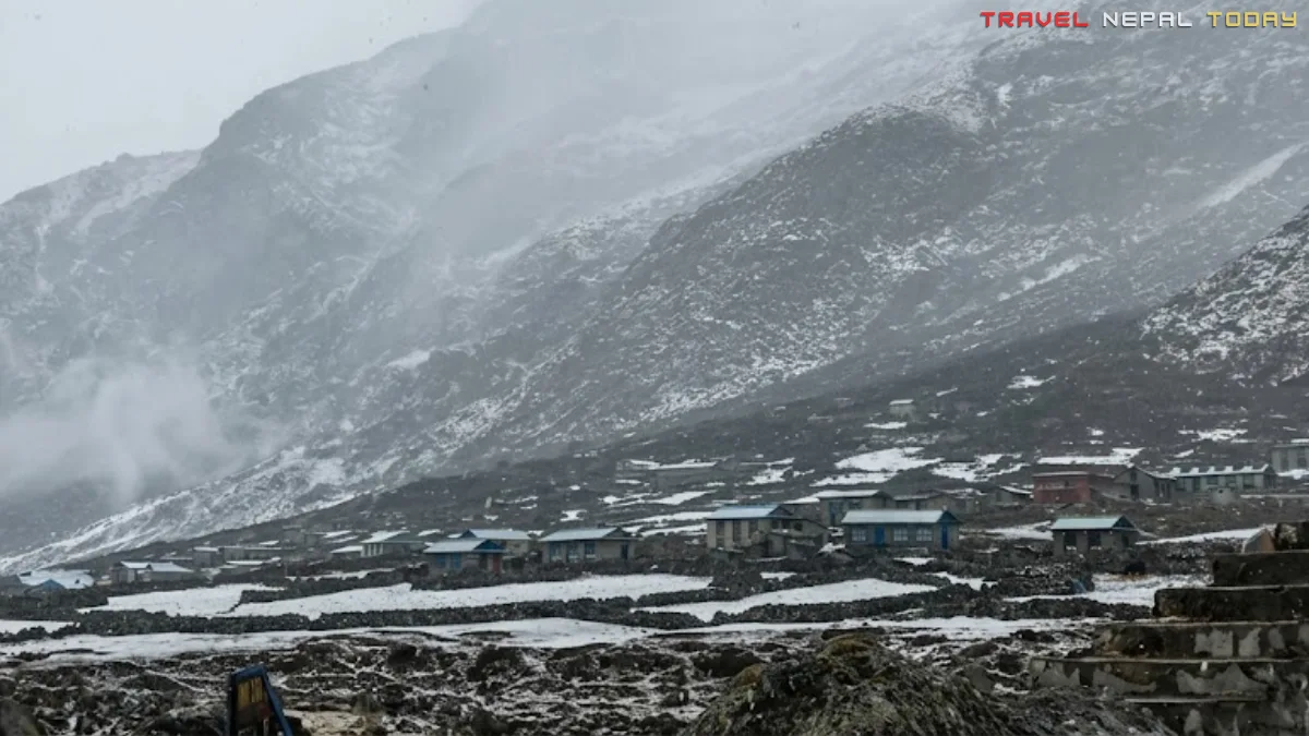
Then came Day 4. The morning was crisp and clear. By the time we reached Dudhkunda, fog had started rolling in. And just as we made it to Tsho Rolpa, the sky turned grey and snowflakes began falling. My first snowfall in the Himalayas, unexpected but completely magical!
That snowfall, that silence, those stories, and that view of the lake through drifting snow became the reason to start my trekking journey. And look I’ve made it this far: working with multiple travel agencies, writing my own blog, and countless more plans ahead of me!
Now, before you go, let me give you everything I wish I had known: the complete guide to Tsho Rolpa Trek with Dudhkunda as an add-on!
A quick stat worth keeping in mind: According to ICIMOD research, Tsho Rolpa has been expanding rapidly and by the late 1990s had already grown to a surface area of 1.55 km² with a water volume of 85.94 million m³. The Trakarding Glacier above it has been retreating at approximately 20 metres per year. This is not just a beautiful lake. It is a living, changing piece of the Himalayas that researchers around the world are watching very closely!
Key Facts About the Tsho Rolpa Dudhkunda Trek
| Primary Lake | Tsho Rolpa, Chhyugima Pokhari |
| Secondary Lake | Dudhkunda / Dudh Pokhari |
| Protected Area | Gaurishankar Conservation Area (GCA) |
| Province | Bagmati |
| District | Dolakha |
| Local Body | Gaurishankar Rural Municipality Ward No. 9 (Restricted Area) |
| Lake Altitude | 4,580 m (Tsho Rolpa) / 4,800 m approx. (Dudhkunda) |
| Lake Length | 3.45 km |
| Lake Width | 0.50 km |
| Surface Area | 1.65 km² |
| Water Volume | 85.94 million m³ |
| Feeding Glacier | Trakarding Glacier |
| Coordinates | 27°52′ N, 86°28′ E |
| Trek Difficulty | Moderate |
| Best Months | March-June, October-December |
Why Choose this Secluded Tsho Rolpa Lake Trek?
Let me be straightforward about something. If you want mountain views, Everest and Annapurna regions will give you those too. So why come here?
Well, because very few others do! That alone makes this valley special.
Treks inside GCA see fewer than 2000 foreign trekkers per year (data from the past two years). Compare that to the thousands who flood Everest Base Camp trails every spring? Surely, the Rolwaling Valley gives you raw, unfiltered Himalaya without the crowds, without the luxury lodges, and without the noise.
Besides less crowd, here are the real reasons to choose this trek:
- Two glacial lakes in one route: You are not just trekking to one destination. Tsho Rolpa and Dudhkunda are both accessible, and together they make for a completely different experience, from a wide turquoise glacial lake to a silent, prayer-flag-lined high alpine pond.
- Rolwaling Himal Range: The mountains you see here are not the ones everyone photographs. The Rolwaling Himal is a range unto itself. Gaurishankar (7,134 m), the mountain that actually determines Nepal’s time zone (the country’s timezone is set based on the longitudinal position of Gaurishankar’s highest peak), Melungtse (7,181 m), Pharchamo (6,279 m), and a full ring of 6,000 m giants surround the upper valley. From Naa onwards, you are walking inside a natural amphitheatre!
- Beyul (sacred, hidden valley): The Rolwaling Valley is considered one of Nepal’s Beyuls, or sacred hidden valleys blessed by Guru Padmasambhava as places of spiritual refuge. The valley’s Tibetan Buddhist heritage is not decorative here. It is part of daily life!
- Snow leopard, Himalayan Wolf, and Red Panda evidence: Yes, the NTNC has confirmed snow leopard presence in the Rolwaling section of GCA. In fact, the first-ever camera trap confirmation of snow leopard, Himalayan wolf, and red panda in GCA was documented in the Rolwaling area in 2020.
- Tales of Yeti: The Rolwaling Valley has one of the most documented Yeti history of any trekking region. Sir Edmund Hillary’s 1960-61 Silver Hut Expedition specifically chose Beding in Rolwaling as its base camp because of concentrated Sherpa Yeti sighting reports in this area. During that expedition, a Sherpa named Mingma reportedly saw a broad-shouldered hairy figure crouching on a boulder near a frozen stream in the valley. The story was never fully explained. Whether you believe in the Yeti or not, sitting in a teahouse in Naa while a family of Sherpa mountaineers shares their valley’s stories is an experience that very few trekking regions of Nepal can offer.
- Home to Sherpa mountaineering guides: Many of Nepal’s finest Everest expedition guides call Rolwaling their home. At Naa village, you will very likely stay in a lodge run by a Sherpa family that has summited Everest multiple times!
Main Highlights of the Tsho Rolpa-Dudhkunda Trek
The Tsho Rolpa-Dudhkunda Trek is not a one-highlight trail. Every section of the Rolwaling Valley gives you something different, and by the time you reach the top, you’ve collected a full set of experiences rather than just a single destination. Here are the major attractions:
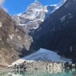
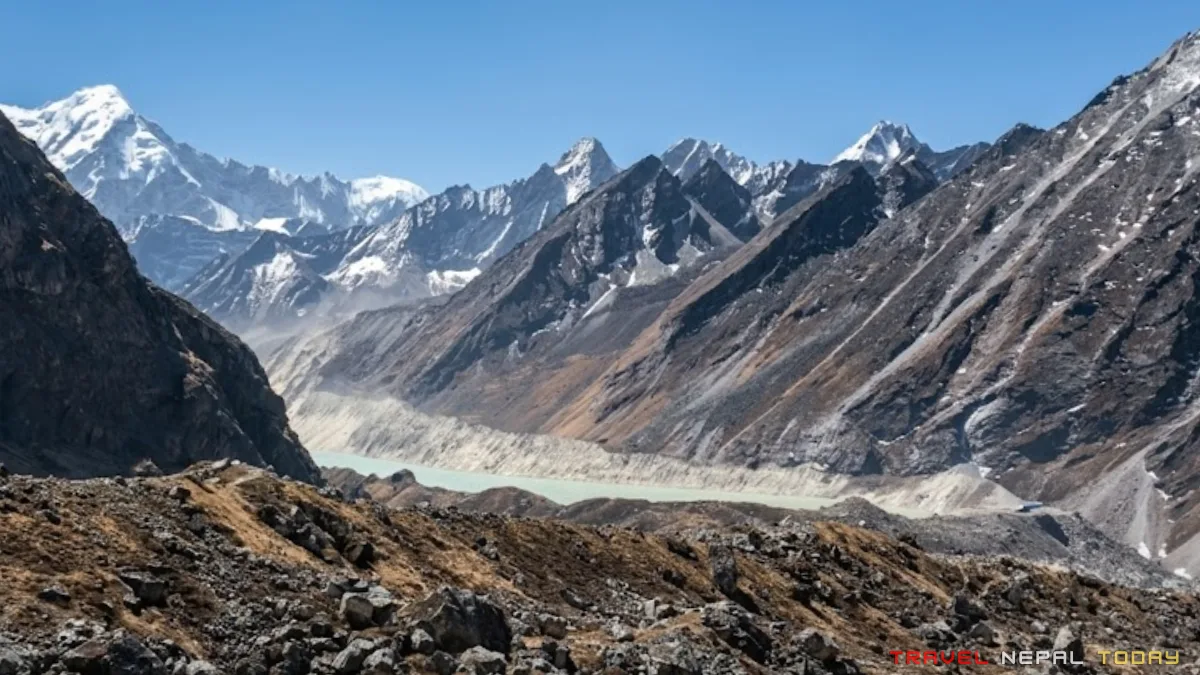
Tsho Rolpa Glacial Lake: The Crown Jewel
According to research, Tsho Rolpa Glacial Lake was developed only in the last 60 or so years, forming on the terminal part of the debris-covered Trakarding Glacier.
Back in 1958, the lake’s surface area at just 0.23 km². By the late 1990s, it had expanded to 1.55 km², and it has continued growing since then (currently, 1.65 sq. km). It’s projected to reach 2.33 sq km in 30 years and 2.53 sq km in 40 years (source).
The lake was so concerning that in 2000, engineering work was actually carried out to lower its water level and reduce the risk of a Glacial Lake Outburst Flood (GLOF). The early warning system installed then became defunct over time, though a more modern system was reported to be in development.
In plain language, the lake is alive and powerful!
As a trekker, you see none of that tension. What you see is an impossibly blue-green body of water ringed by the Rolwaling Himal.
From the settlement of Chukyima near the lake, the 360-degree mountain panorama opens up to include peaks like Thakar Go (6,771 m), Langmoche Ri (6,617 m), Tengi Ragi Tau (6,938 m), Pharchamo (6,279 m), Linkhu Chuli I (6,719 m), and Linkhu Chuli II aka Big Pherago Nup (6,659 m), in addition to all the peaks visible from Na.
The best time to be at the lake is early morning, as afternoon fog rolls in fast, something that I learned from my own trip.
Dudhkunda: The Hidden Pond You Should Not Skip
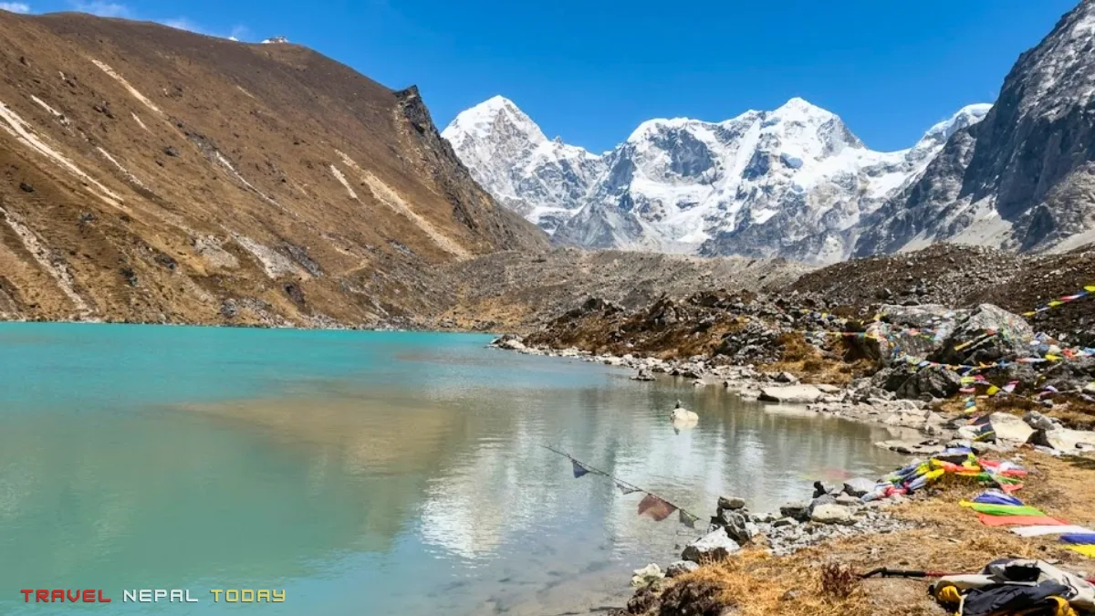
Dudhkunda (also referred to as Dudh Pokhari) sits at approximately 4,700 to 4,800 m above the main Tsho Rolpa trail, reachable from Naa village in about 3 hours.
Most trekkers skip it because the route is not as well-marked and involves a rugged section that passes through an avalanche-prone area and a landslide section before connecting back to the main route toward Tsho Rolpa.
I say do not skip it!
Here is what you find at Dudhkunda:
- A small high-alpine pond, almost perfectly still, with prayer flags strung across boulders around its edge and glacial meltwater feeding it with a silence that is hard to describe.
- The milky-white glacial water giving it its name reflects the sky and the surrounding peaks in a way that makes you stop walking just to look.
- An additional set of mountains becomes visible from this altitude, including Langdung (6,326 m), Khang Karpo (6,646 m), and Thaknak Ri aka Dragnag Ri (6,757 m).
The approach from Naa is a dry, thin-aired uphill climb. This is where my nose started to bleed on our way back, which confused me at the time.
It turns out that at high altitudes, the air becomes much drier and the atmospheric pressure drops. The combination of lower pressure inside the blood vessels versus the outside atmosphere, combined with extremely dry air drying out the nasal membranes, makes them brittle and prone to cracking.
The simple fix is to stay well-hydrated, use a saline nasal spray, and avoid picking or blowing your nose forcefully
Tip: Leave early for Dudhkunda. The dry mountain air that causes this becomes worse as the morning wears on and you exert more energy in thin air.
Since there is a direct connecting route from Dudhkunda to Tsho Rolpa taking about 2 hours, you can visit Dudhkunda first and then continue to Tsho Rolpa without backtracking all the way to Na.
Just be aware that this connecting route has a landslide section. When we did this trek in April 2022, we went with a local guide who knew the trail well, and he took us through an alternate path that was a little longer but safer!
The Main Villages Along the Trail
Tsho Rolpa and Dudhkunda both sit inside Ward 9 of Gaurishankar Rural Municipality in Dolakha district. The valley you trek through from Chetchet to finish is the Rolwaling Valley, named after the Rolwaling Himal range that frames it.
Now, let’s understand the main locations you’ll pass by in a little more detail.
Introduction to Rolwaling Valley and Gaurishankar Rural Municipality
The Rolwaling Valley stretches along the Nepal-Tibet border in Dolakha District, about 162 km east of Kathmandu.
The valley runs between the Nangpa La pass in the east and the Tamakoshi River in the west. This is not a wide, accessible valley, but rather a narrow, steep, glacier-fed, and intentionally difficult to reach region, which is precisely why it has stayed this way.
The valley is part of Gaurishankar Rural Municipality and falls within the Gaurishankar Conservation Area.
Per the National Population and Housing Census 2021, this municipality has a total population of 15,995. While the Kshetri community dominates the region with 29.1% (mainly in the lower region), Sherpa make up 23.7% of the gaupalika’s population.
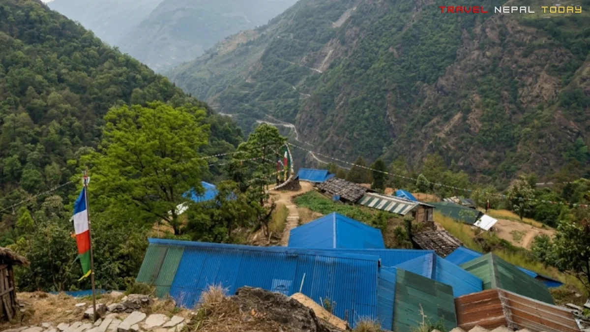
Chetchet (1,410 m): Where Your Trek Begins!
Chetchet (also written Chhetchhet or Chhyot Chhyot) is the gateway to the Rolwaling Valley. At 1,410 m, it sits at the confluence of the Rolwaling Khola and the Tama Koshi River.
This is the last stop where you can stock up on supplies before the trail gets serious. There are a few basic shops and lodges here, and you will also see the Rolwaling Valley map board that gives you your first proper look at what lies ahead!
The trail officially begins right after you cross the Tama Koshi bridge and start the uphill climb toward Simi Gaun.
Simi Gaun (2,000 m): Your First Night
Most trekkers reach Simi Gaun on Day 1 after arriving in Chetchet by vehicle (which is exactly what me and my friends did).
The name “Simi” in Nepali refers to beans, and the village is known for its agricultural terraces.
This is a mixed community of Kshetri, Tamang and other ethnic groups in the lower section of the trail. There are multiple lodges here, and it is a good place to recover from the long bus ride before the real climbing begins the next day.
I remember arriving here tired from the drive but immediately feeling the shift in atmosphere. No road noise, just the sound of the river below and birds above.
Beding (3,740 m): The Heart of Rolwaling
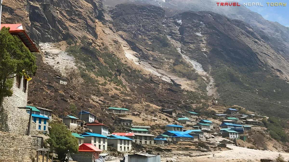
Beding is the most important and largest village in the Rolwaling Valley. It functions as the central or intermediate village, bridging the lower winter settlements and the upper summer settlement at Na.
The Sherpas of Rolwaling traditionally lead a semi-nomadic life, moving with their herds based on the season.
The Rolwaling Sangag Choling Monastery is located here. There is also a short hike to Beding Gompa from the village. Two things worth doing before you continue (or when returning)!
Do not leave Beding without asking the local Sherpa families about their Yeti stories. Not as entertainment, but as cultural listening!
These communities have shared this valley with whatever it is for generations, and their accounts are genuine and specific to places you will pass through.
Naa Village (4,180 m): The Highest Village of Dolakha
Naa is the summer residence of the Rolwaling Sherpa community and the highest permanent village in Dolakha District.
It sits on a gently sloping plateau surrounded on three sides by mountains and is home to approximately 50 to 60 houses, mostly inhabited by Sherpa families.
Here is something remarkable about Naa that most guides do not tell you: A local lama once declared it a “violence-free zone”. So, no animal hunting or killing is permitted in this village!
Even the yaks, when they grow old, are left to die a natural death. Reportedly, the Dalai Lama himself sent 108 sheep to Rolwaling to live freely, and Lama Zopa Rinpoche of Kopan Monastery freed 108 yaks in the surrounding area.
It is also here that you will meet mountaineering families whose stories of Everest ascents, expedition life, and close encounters with the mountain will reshape how you think about Himalayan climbing.
During our own trip, we stayed in the hotel of a local mountaineer whose entire family had summited Everest. He shared practical tips about altitude, breathing, and pacing that proved more useful than anything I had read before!
He also told us, quietly and matter-of-factly, about what his grandmother had seen near the glacier above Naa many years ago. He did not call it a Yeti. He described it as “the valley’s protector”, something that watches from higher ground.
From Naa, on a clear day, you can see Cheki Go (6,121 m), Khang Nachu Go (6,737 m), Omi Tso Go (6,332 m), Chobuje (6,685 m), Chukyima Go (6,258 m), Ramdong Go (5,900 m), Yalung Ri (5,630 m), Dorje Phagmo (5,636 m), and Tabayabyum (5,558 m).
More on Sherpa Community of Rolwaling: What You Should Know
The Sherpas who live in the Rolwaling Valley are not the same community you meet in Namche Bazaar or along the Everest trails. The Rolwaling Sherpa clans are distinct, with their own lineage and traditions.
The main clans in the valley include Chusherpa (also called Ngonpa/Ngonba), Murminso, Rukpa, Sakywa, Lakshindo, Salakha, and Sangu.
These Sherpas came from Tibet to the Khumbu region and Rolwaling and settled here, with history suggesting Rolwaling was only populated after 1870!
They first lived in caves, and later built permanent houses. Their seasonal movement pattern still continues today. They spend summers and autumn at Naa and above, then descend to lower winter villages with their herds as temperatures drop.

The Beyul belief runs deep here. The valley is considered one of the sacred hidden valleys (Beyul Kyimalung) blessed by Guru Padmasambhava as places of refuge and spiritual practice. Local communities actively protect the valley’s forests, water sources, and wildlife as a direct result of this belief.
In fact, a research paper on avifaunal composition in GCA noted that the “Beyul” culture practiced by local Buddhists has directly contributed to the protection of biodiversity, including birds.
Talking about Festivals in Rolwaling, the Sherpa communities here celebrate Gyalpo Lhosar (Tibetan New Year), Dumje (a major Sherpa festival celebrated at the Beding monastery), and Nyi Lha Gyalpo.
Walking Beside the Rolwaling Kosi Khola
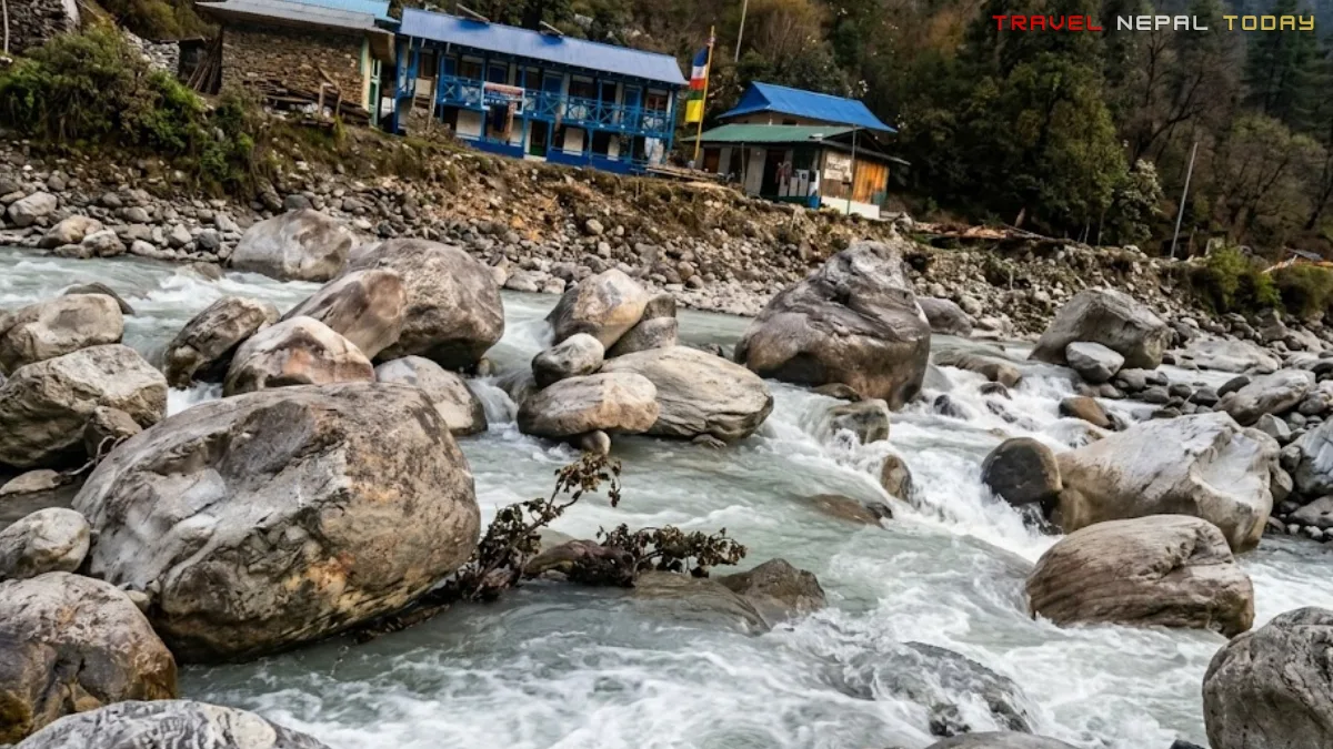
From the moment you cross the bridge at Chetchet, the Rolwaling Kosi Khola (also called Rolwaling River) becomes your constant companion. This river flows directly from Tsho Rolpa Lake high above and winds all the way down through the valley before joining the Tama Koshi River near Chetchet.
That milky, glacially fed current you see at Chetchet has traveled the entire length of the route you are about to walk!
As you ascend toward Beding, you will also cross the Chhesugolcha Khola at Ramding village, a tributary that joins the main river.
The Tsho Rolpa trekking trail crosses the Rolwaling Kosi Khola multiple times via wooden bridges, one of the most notable being the bridge at Shikhar Dovan that takes you toward Beding.
In the lower sections between Chetchet and Kyalche, you walk through a corridor of waterfalls. These are not small trickles. The southern slope of this valley receives significant rainfall and snowmelt, and between late spring and monsoon, the waterfalls are thunderous! Even in April, they were impressive, really.
Flora and Fauna of the Gaurishankar Conservation Area
GCA is one of Nepal’s most biodiverse protected areas, positioned between Langtang National Park and Sagarmatha National Park and connecting their ecosystems.
According to the most recent checklist data from research publications, the conservation area supports:
- 77 species of mammals
- 235 species of birds
- 27 species of reptiles
- 12 species of amphibians
- 16 fish species
- 16 major vegetation types
Wildlife Along the Rolwaling Trail
The Rolwaling section is one of the most wildlife-rich corridors within GCA. Here is what you can realistically spot along the trail, based on verified research and community reports:
- Himalayan Tahr: The most commonly spotted large mammal on this trail. You’ll see them grazing on rocky ridges above Beding and Naa, large shaggy-coated wild goats that seem completely unbothered by trekkers passing below them.
- Himalayan Black Bear: Present throughout the mid-altitude forested sections of the valley. Not typically aggressive unless surprised. Move in groups and make noise on the trail, especially in the denser sections between Chetchet and Dongang.
- Himalayan Musk Deer: More common in the dense forest sections between Chetchet and Dongang. Shy and fast, so you’ll need a bit of luck to catch a proper sighting.
- Red Panda: Confirmed by camera trap within GCA, found in the temperate mixed forests between roughly 2,500 m and 4,000 m. That means you pass directly through their habitat in the Surmuche to Beding section. Spotting one is rare but not impossible.
- Snow Leopard: Camera trap evidence confirmed in Rolwaling by the NTNC team, making this the first documented camera trap confirmation of snow leopard in GCA. Your chances of actually seeing one on the trail are extremely slim. But you are walking through their territory, and that alone is something!
Sadly, our team didn’t encounter any during our trek in April 2022.
Flora Along the GCA Trail
The trail passes through an extraordinary range of vegetation zones over just 6 to 7 days. Starting from the subtropical riverine forests at Chetchet (1,410 m), you move through:
- Dense bamboo and hanging-moss forests in the lower sections (one of the most atmospheric sections of the trail)
- Rhododendron forests in full bloom during March and April between Simi Gaun and Dongang
- Mixed temperate oak and pine forest through the Beding corridor
- High alpine scrub and meadows above Naa
- Rocky, glacially sculpted terrain approaching Tsho Rolpa
The 16 vegetation types in GCA include forests of Pinus roxburghii, Schima-Castanopsis, Alnus, Pinus wallichiaNaa, Rhododendron, Quercus lanata, and Temperate Mountain oak.
How to Reach the Starting Point Chetchet?
As I’ve mentioned multiple times, Chetchet sits at 1,410 m in the Rolwaling Valley and is where your trek officially begins. Now, let’s understand how you can reach there.
The road route from Kathmandu is the same whether you take a bus, jeep, or motorcycle:
Kathmandu > Bhaktapur > Dhulikhel (Kavre) > Zero Kilo > Dolalghat > Sukute (Sindhupalchok) > Khadichaur > Mude > Charikot > Dolakha Bhimsen > Singati > Bhorle Waterfall > Chetchet
On Public Bus (What We Took)
Buses for this route depart from Chabahil Chowk and Koteshwor in Kathmandu. The bus operated by Rolwaling Yatayat is the main service on this route, and tickets can be booked online!
The bus departs as early as 4:00 AM from Chabahil if you want a seat. The journey takes 8 to 10 hours, because the bus slows significantly after Charikot. It goes slowly so it can pick up more passengers (very common in Nepal).
Fare is roughly around Rs. 500 to 700 per person (current prices may vary, so check before booking).
On Private Jeep
Faster and more comfortable than the long bus ride for sure! The same route takes about just 6 to 7 hours!
Well, there are various jeep services available from Kathmandu, typically from Chabahil or Koteshwor area. So, you can head there directly and negotiate the fare for your group.
Via Motorcycle
If you want to take your ride, this is actually a great option! 6 to 7 hours (or even if you take more) while enjoying the scenic route along the Araniko Highway and taking the diversion from Khadichaur towards Mude.
I’ve driven this route a couple of times, and it’s totally worth it! In fact, you could even visit multiple other attractions in Dolakha this way if you’re one of those explorers.
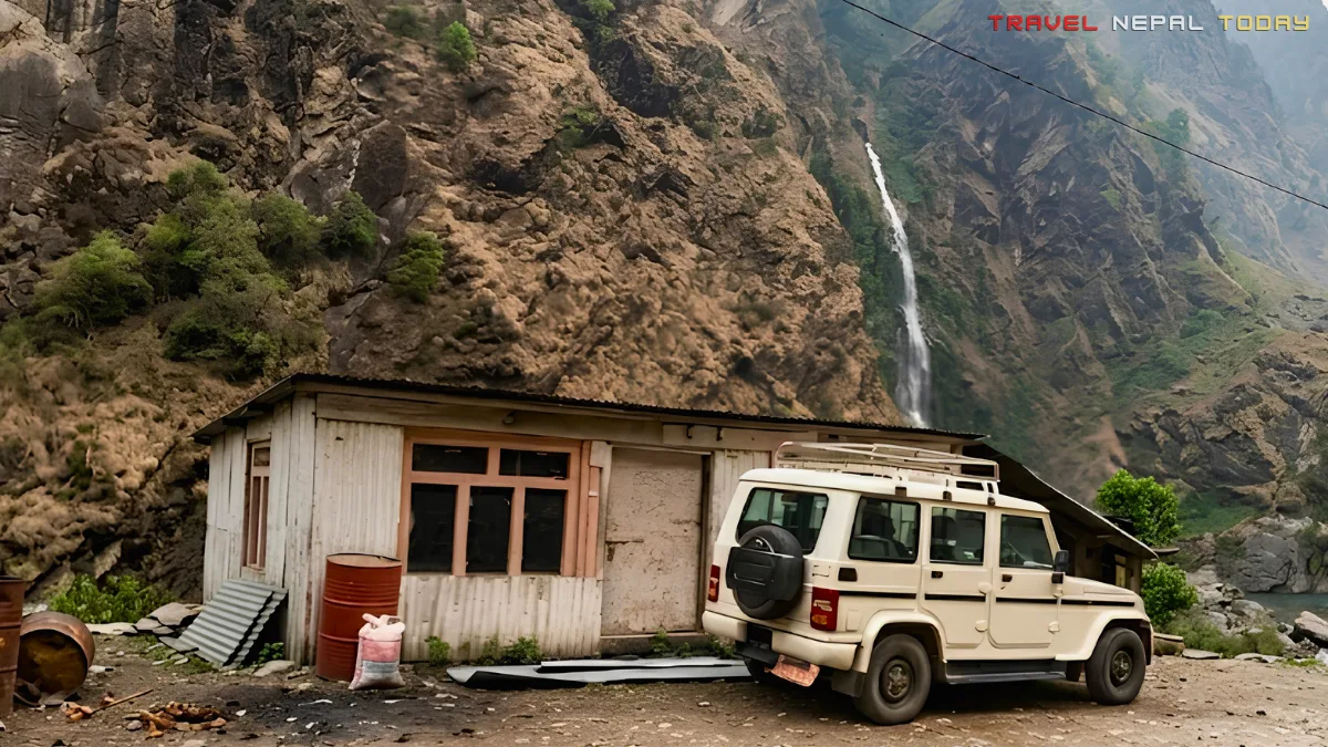
And once you’re on the way to Chetchet via Charikot and Singati, this option gives you the freedom to stop at Bhorle Waterfall too.
Road Conditions: What to Actually Expect
The Banepa to Dhulikhel stretch of Araniko Highway has had ongoing repair work for years and can be slow and bumpy:
From Dhulikhel to Singati, the road is largely black-topped and manageable (except from Banepa to Dhulikhel, which is a different story). After Singati, the road quality deteriorates noticeably.
The highlight and slightly terrifying section is Bhorle Waterfall, where the road literally passes directly underneath a waterfall. If the flow is heavy, the bus goes through it anyway. It is wet, dramatic, and honestly one of the more memorable parts of the road journey!
From Bhorle to Chetchet, the road is unpaved and paved in stretches. It is manageable in dry conditions but during heavy monsoon rainfall, this section can get tricky. However, it remains passable in most cases!
One important note: You’ll also find jeeps from Chetchet to Gongar (after the trek ends). The ride is about 3 km long. Why Gongar is because it has better lodges and buses also typically depart from here on the return journey.
Tsho Rolpa Lake Trek Route and Map
Now let’s get into the route. Here is the full Tsho Rolpa Lake Trek mapped out from Chetchet to Tsho Rolpa and Dudhkunda, so you know exactly what you’re walking into before you start.
Trek Route Map
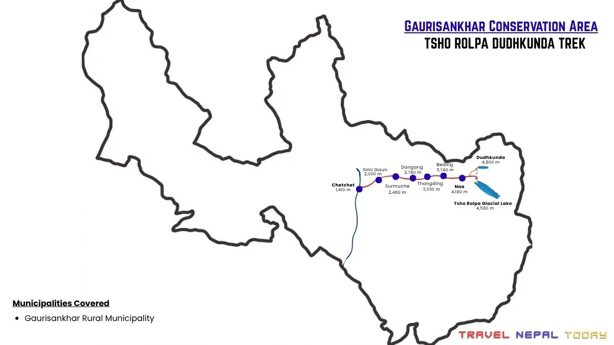
Route Breakdown With Distances, Times, and Highlights
Here is every segment of the trail with distances, walking times, elevation, and what to expect on each stretch. Use this as your day-planning reference rather than a strict schedule, because your actual pace will depend on weather, group fitness, and how long you stop along the trail:
| Section | Distance | Duration | Highlight |
| Chetchet (1,410 m) to Simi Gaun (2,000 m) | 2.5 km | 2.5-3 hrs | Complete uphill, waterfalls on all sides |
| Simi Gaun (2,000 m) to Uttise (2,065 m) | 2 km | 1-1.5 hrs | Rikhu village visible across the river |
| Uttise (2,065 m) to Surmuche (2,480 m) | 2.5 km | 2 hrs | Pass Bamboo Bhatti on the way |
| Surmuche (2,480 m) to Kyalche (2,740 m) | 3 km | 4 hrs | Dense forested uphill trail |
| Kyalche (2,740 m) to Dongang (2,780 m) | 1.5 km | 1-1.5 hrs | Peaceful riverside spot (hotels destroyed by 2024 flood) |
| Dongang (2,780 m) to Thangdingma (3,330 m) | 4.5 km | 3.5-4 hrs | Gradual uphill, forest transitions |
| Thangdingma (3,330 m) to Beding (3,740 m) | 5.5 km | 5-6 hrs | Cross Shikhar Dovan bridge, Sumda Mahadev Statue, Chhesugolcha Khola at Ramding, pass Chhimu, arrive at village of gompas |
| Beding (3,740 m) to Naa (4,180 m) | 6.5 km | 4-4.5 hrs | Surrounded by Rolwaling range peaks |
| Naa (4,180 m) to Tsho Rolpa (4,580 m) | 6 km | 4 hrs | 360-degree mountain views from Chukyima settlement |
| Naa (4,180 m) to Dudhkunda (4,800 m approx.) | 5 km | 3 hrs | High alpine pond with prayer flags, rugged trail |
| Dudhkunda (4,800 m approx.) to Tsho Rolpa (4,580 m) | 4.5 km | 2 hrs | Landslide section, connects to main trail |
| Chetchet (1,410 m) to Gongar (1,260 m) | 3 km | 10 min drive | End-of-trek jeep ride option |
| Total one-way distance (Tsho Rolpa only) | approx. 33 km | ||
| Total two-way distance (Tsho Rolpa only) | approx. 66 km | ||
| Total two-way distance (with Dudhkunda) | approx. 70 km | ||
The Route Explained
Here is how the trail actually feels, section by section, based on what I experienced in April 2022:
- Chetchet to Simi Gaun: Starting from Chetchet, you cross the Tama Koshi River bridge and immediately begin the uphill climb toward Simi Gaun. This is a steep start. No warmup, no flat section. Just uphill through dense forest with waterfalls cascading down the slopes on your left and right.
- Simi Gaun to Uttise: The next morning, the trail continues toward Uttise. On the opposite bank of the Rolwaling River, you will spot Rikhu village perched across the gorge, unreachable from this side without going back down.
- Uttise to Surmuche: From Uttise, the climb to Surmuche continues. This entire lower stretch of the trail, from Chetchet all the way to about Dongang, is a corridor of waterfalls. Even in April, they were in full voice, particularly the ones we encountered near Surmuche.
- Surmuche to Kyalche: The route up to Kyalche is almost entirely uphill with only minor flat sections.
- Kyalche to Dongang or Thangding: Then comes a short descent to Dongang, where we had actually spent the night during our April 2022 trip. I have to be honest: the teahouses we stayed in then were simple but functional. However, the 2024 floods destroyed the hotels in Dongang completely. As of now, you should plan to push on to Thangdingma (or simply Thangding), which is about 1.5 hours further. The river section at Dongang is still beautiful for a quick rest stop during the day.
- Thangdingma to Ramding: This stretch is the trail’s most memorable long day. You pass Shikhar Dovan, where a wooden bridge takes you across the Rolwaling Khola. Shortly after, you reach the Sumda Mahadev Statue, where the trail diverges. One way leads toward Beding, the other toward Daldung Peak. On a clear day from this junction, Gaurishankar (7,181 m) appears in the distance, massive and completely imposing. Before reaching Beding, the trail passes through Ramding, where the Chhesugolcha Khola joins the main valley.
- Ramding to Beding: Then, you’ll pass through Chhimu, home to the Rolwaling Sangag Choling Monastery School before entering Beding. When here, you may climb up to the Sanga Chhyoling Monastery if you have the energy. Visit the Guru Rinpoche Cave just outside the village.
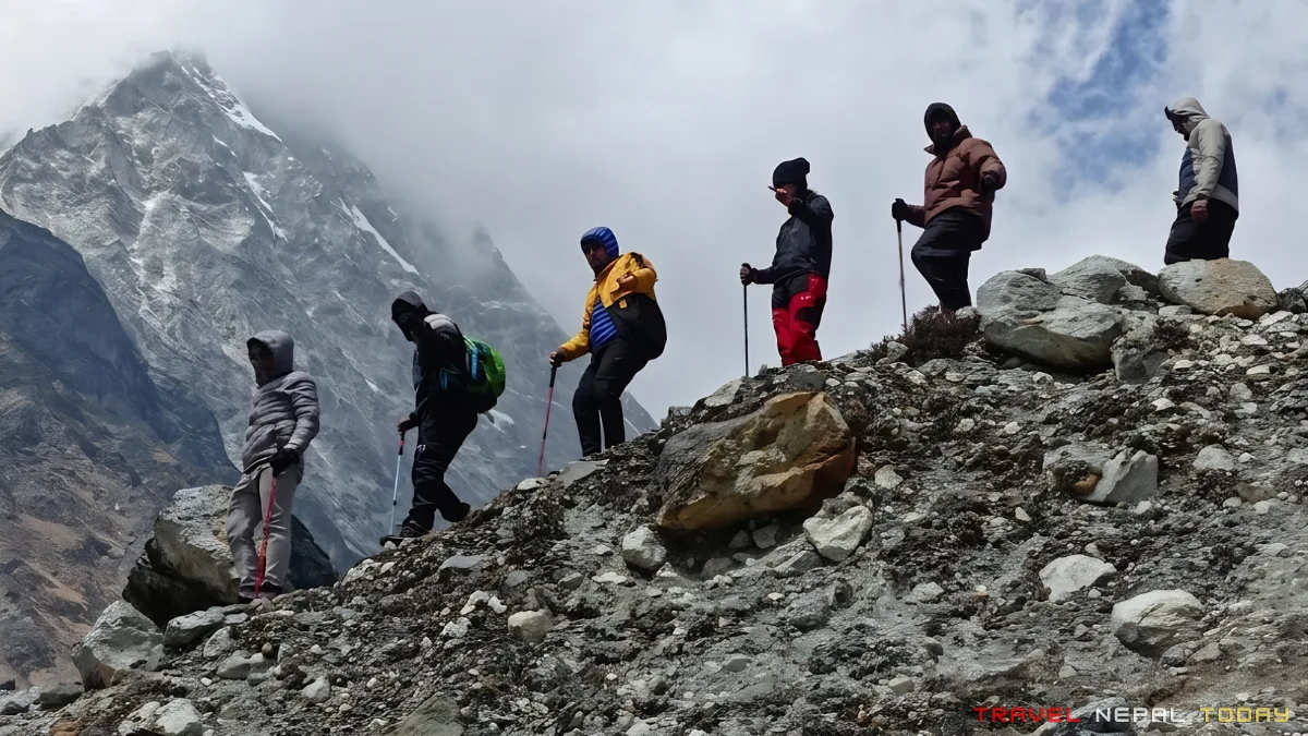
- Beding to Naa: This section is where the trail gets rugged. Multiple uphill sections, rocky terrain, and the air thinning noticeably. But by the time you arrive at Naa and settle into a Sherpa home-turned-guesthouse, the mountains framing every window make it worthwhile. Naa village also has a Guru Rinpoche Cave Temple just before the final approach.
- Naa to Dudhkunda: From Naa, the best plan is to go to Dudhkunda early the next morning before the dry mountain air gets harsh, and then continue to Tsho Rolpa via the connecting route. Our group did it in a single long day and returned to Beding by evening, exhausted but completely satisfied.
- Dudhkunda to Tsho Rolpa: The climb to Tsho Rolpa in the final section is steep. There is no gentle way to say it. And when you finally reach the lake edge, if you are there in shoulder season, expect cloud and possibly snow. We were fogged in within minutes of arriving, and the snowfall that followed was surreal!
- Return Route: The return is the same trail in reverse. Mostly downhill! If you want to save about an hour, there is an alternate return route via Rikhu village instead of Simi Gaun. The route is less marked, so ask a local at Surmuche or Uttise for directions before committing to it.
Best Tsho Rolpa Lake Trek Itineraries
The trail is flexible enough for a 5-day sprint or a relaxed 7-day journey. Here are three options based on different starting fitness levels and time availability:
Itinerary 1: 5-Day Short Trek
This one is for trekkers who are short on time but in solid shape.
Day 1: Kathmandu to Chetchet (Drive), Trek to Simi Gaun
| Drive Duration | 8-10 hrs by bus / 6-7 hrs by jeep |
| Hike Distance | 2.5 km |
| Hike Duration | 2.5-3 hrs |
| Elevation Gain | +590 m |
| Route | Chetchet (1,410 m) > Simi Gaun (2,000 m) |
| Difficulty | Moderate |
Day 2: Simi Gaun to Beding
| Hike Distance | Approx. 18.5 km |
| Hike Duration | 9-10 hrs |
| Elevation Gain | +1,740 m |
| Route | Simi Gaun (2,000 m) > Uttise (2,065 m) > Surmuche (2,480 m) > Kyalche (2,740 m) > Dongang (2,780 m) > Thangdingma (3,330 m) > Beding (3,740 m) |
| Difficulty | Hard |
Day 3: Beding to Tsho Rolpa via Naa
| Hike Distance | Approx. 12.5 km |
| Hike Duration | 8-9 hrs |
| Elevation Gain | +840 m |
| Route | Beding (3,740 m) > Naa (4,180 m) > Chukyima > Tsho Rolpa (4,580 m) |
| Difficulty | Hard |
Day 4: Dudhkunda Visit, Descend to Thangdingma
| Hike Distance | Approx. 17 km |
| Hike Duration | 8-9 hrs |
| Elevation Gain | +620 m |
| Elevation Loss | -1,470 m |
| Route | Naa (4,180 m) > Dudhkunda (4,800 m approx.) > Naa > Beding (3,740 m) > Thangdingma (3,330 m) |
| Difficulty | Moderate to Hard |
Day 5: Thangdingma to Chetchet, Drive to Kathmandu
| Hike Distance | Approx. 14 km |
| Hike Duration | 7-8 hrs |
| Elevation Loss | -1,920 m |
| Drive Duration | 8-10 hrs to Kathmandu |
| Route | Thangdingma (3,330 m) > Dongang (2,780 m) > Kyalche (2,740 m) > Surmuche (2,480 m) > Uttise (2,065 m) > Simi Gaun (2,000 m) > Chetchet (1,410 m) > Gongar (1,260 m) |
| Difficulty | Moderate |
| Note | Jeep ride from Chetchet to Gongar takes approx. 10 minutes |
Itinerary #2: 6-Day Trek (Recommended)
This is the balanced option, not too rushed, perfect (and the one we followed):
Day 1: Kathmandu to Chetchet (Drive), Trek to Simi Gaun
| Drive Duration | 8-10 hrs by bus / 6-7 hrs by jeep |
| Hike Distance | 2.5 km |
| Hike Duration | 2.5-3 hrs |
| Elevation Gain | +590 m |
| Route | Chetchet (1,410 m) > Simi Gaun (2,000 m) |
| Difficulty | Moderate |
Day 2: Simi Gaun to Thangdingma
| Hike Distance | Approx. 11.5 km |
| Hike Duration | 7-8 hrs |
| Elevation Gain | +1,330 m |
| Route | Simi Gaun (2,000 m) > Uttise (2,065 m) > Surmuche (2,480 m) > Kyalche (2,740 m) > Dongang (2,780 m) > Thangdingma (3,330 m) |
| Difficulty | Moderate to Hard |
| Note | Dongang hotels were destroyed by the 2024 flood, so Thangdingma is the recommended overnight stop |
Day 3: Thangdingma to Na
| Hike Distance | Approx. 12 km |
| Hike Duration | 7-8 hrs |
| Elevation Gain | +850 m |
| Route | Thangdingma (3,330 m) > Ramding > Chhimu > Beding (3,740 m) > Naa (4,180 m) |
| Difficulty | Moderate |
Day 4: Dudhkunda and Tsho Rolpa Visit, Descend to Beding
| Hike Distance | Approx. 15.5 km |
| Hike Duration | Full-day hike |
| Elevation Gain | +620 m |
| Elevation Loss | -1,060 m |
| Route | Naa (4,180 m) > Dudhkunda (4,800 m approx.) > Tsho Rolpa (4,580 m) > Naa > Beding (3,740 m) |
| Difficulty | Hard |
Day 5: Beding to Chetchet, Drive to Gongar
| Hike Distance | Approx. 22 km |
| Hike Duration | 8-9 hrs |
| Elevation Loss | -2,330 m |
| Drive Duration | 10 mins jeep ride |
| Route | Beding (3,740 m) > Thangdingma (3,330 m) > Dongang (2,780 m) > Kyalche (2,740 m) > Surmuche (2,480 m) > Uttise (2,065 m) > Simi Gaun (2,000 m) > Chetchet (1,410 m) |
| Difficulty | Moderate |
Day 6: Gongar to Kathmandu
| Drive Duration | 8-9 hrs |
| Route | Gongar (1,260 m) > Kathmandu |
| Difficulty | Easy |
Itinerary #3: 7-Day Trek (Relaxed and Thorough)
For those who want to properly experience every part of the valley without rushing, this 7-day Tsho Rolpa Trek would be the best bet:
Day 1: Kathmandu to Chetchet (Drive), Trek to Simi Gaun
| Drive Duration | 8-10 hrs by bus / 6-7 hrs by jeep |
| Hike Distance | 2.5 km |
| Hike Duration | 2.5-3 hrs |
| Elevation Gain | +590 m |
| Route | Chetchet (1,410 m) > Simi Gaun (2,000 m) |
| Difficulty | Moderate |
Day 2: Simi Gaun to Thangdingma
| Hike Distance | Approx. 11.5 km |
| Hike Duration | 7-8 hrs |
| Elevation Gain | +1,330 m |
| Route | Simi Gaun (2,000 m) > Uttise (2,065 m) > Surmuche (2,480 m) > Kyalche (2,740 m) > Dongang (2,780 m) > Thangdingma (3,330 m) |
| Difficulty | Moderate to Hard |
Day 3: Thangdingma to Naa
| Hike Distance | Approx. 12 km |
| Hike Duration | 7-8 hrs |
| Elevation Gain | +850 m |
| Route | Thangdingma (3,330 m) > Ramding > Chhimu > Beding (3,740 m) > Naa (4,180 m) |
| Difficulty | Moderate |
| Highlight | Explore Beding monastery and village en route |
Day 4: Tsho Rolpa and Dudhkunda Exploration
| Hike Distance | Approx. 15.5 km |
| Hike Duration | Full acclimatization day |
| Elevation Gain | +620 m |
| Route | Naa (4,180 m) > Dudhkunda (4,800 m approx.) > Tsho Rolpa (4,580 m) > Naa |
| Difficulty | Moderate to Hard |
Day 5: Naa to Surmuche
| Hike Distance | Approx. 18 km |
| Hike Duration | 8-9 hrs |
| Elevation Loss | -1,700 m approx. |
| Route | Naa (4,180 m) > Beding (3,740 m) > Thangdingma (3,330 m) > Dongang (2,780 m) > Kyalche (2,740 m) > Surmuche (2,480 m) |
| Difficulty | Moderate |
| Highlight | Spend extra time exploring Beding monastery and cave |
Day 6: Surmuche to Chetchet, Drive to Gongar
| Hike Distance | Approx. 8 km |
| Hike Duration | 4-5 hrs |
| Elevation Loss | -1,070 m |
| Drive Duration | 10 mins jeep ride |
| Route | Surmuche (2,480 m) > Uttise (2,065 m) > Simi Gaun (2,000 m) > Chetchet (1,410 m) |
| Difficulty | Easy to Moderate |
Day 7: Gongar to Kathmandu
| Drive Duration | 8-9 hrs |
| Route | Gongar (1,260 m) > Kathmandu |
| Difficulty | Easy |
| Note | Early departure recommended due to road conditions |
Difficulty Level of Tsho Rolpa Dudhkunda Trek
This is a moderate level trek. Not easy, not extreme. Even beginners can absolutely do it.
I did it as my very first high-altitude trek. But still, beginners need to be honest with themselves about the uphills and give themselves proper time.
The toughest section in terms of physical demand are:
- Steep climb from Chetchet to Simi Gaun right on Day 1. You are going uphill from minute one.
- The climb from Simi Gaun to Surmuche continues the same uphill pattern the next day.
- And then the approach from Naa to Dudhkunda at over 4,500 m is genuinely challenging when your body is still adjusting to that altitude.
Altitude sickness is a real risk. Sleeping at Naa (4,180 m) is a significant threshold!
Your body will feel that difference. Headache, poor sleep, reduced appetite, and general fatigue are common.
The solution is simple: go slow, drink more water than you think you need (minimum 3 to 4 litres per day from Naa onwards), and do not push beyond your symptoms. The “go slow” principle is not just a cliché here.
Best Time for the Tsho Rolpa-Dudhkunda Trek
Let me give you the straight answer first. Spring (March-May) and Autumn (October-November) are the peak trekking seasons. But even then, the Rolwaling Valley sees far fewer trekkers compared to Everest and AnnapurNaa regions.
Every season has something to offer! But weather windows are everything, and with season creep due to climate change, unexpected rain or snowfall can happen even in “safe” months.
Use weather apps to check conditions a week before your departure. I generally use zoom.earth three to four days (it’s mostly accurate).
Below is a six-season breakdown in Nepal’s traditional calendar, with practical weather data averaged from past three years:
Spring / Basanta (March and April)
This is when the rhododendrons bloom across the lower valley. The forests between Simi Gaun and Dongang turn extraordinary shades of red and pink. Mountain views are clear in the morning before afternoon clouds build.
| Factor | March | April |
| Avg Daytime Temp | 5-12°C | 8-15°C |
| Avg Night Temp (Naa level) | -3 to 2°C | 0 to 5°C |
| Snowfall Probability | Moderate | Low |
| Rainfall Probability | Low-Moderate | Low-Moderate |
| Sky Condition | Mostly Clear | Mostly Clear |
| Visibility | Good to Excellent | Good to Excellent |
| Trail Condition | Possible snow above Na | Clear generally |
| Cerdict | Rhododendrons in bloom, great views, occasional snow near Tsho Rolpa | Best month overall |
Summer / Grishma (May and June)
May is a quiet shoulder month with good temperatures and almost no crowds. Worth considering if you want Spring conditions with even fewer people.
| Factor | May | June |
| Avg Daytime Temp | 10-18°C | 12-18°C |
| Avg Night Temp (Naa level) | 2-7°C | 5-10°C |
| Snowfall Probability | Very Low | Very Low |
| Rainfall Probability | Moderate (pre-monsoon) | High |
| Sky Condition | Partly Cloudy | Cloudy-Rainy |
| Trail Condition | Good | Slippery in sections |
| Verdict | Perfect in May | June: check weather window, early weeks can be great |
Monsoon / Barsha (July to September)
Monsoon can actually be beautiful in the lower sections of the valley. Waterfalls are enormous. The valley turns an impossibly deep green.
But the road conditions from Singati to Chetchet get difficult after heavy rain, and leeches are relentless from Chetchet to about Kyalche.
After mid-September, the monsoon begins withdrawing but you still need to check weather window!
| Factor | July | August | September |
| Avg Daytime Temp | 14-20°C | 14-20°C | 12-18°C |
| Avg Night Temp (Naa level) | 5-10°C | 5-10°C | 3-8°C |
| Snowfall Probability | Very Low | Very Low | Low |
| Rainfall Probability | High | Very High | High |
| Trail Condition | Muddy, leeches | Muddy, leeches | Improving |
| Verdict | Hard to manage | Hard to manage | Wait for weather windows (due to climate change, even up to early October there’s heavy rain these days) |
Autumn / Sharad (October to Mid-November)
October is arguably the single best month for this Tsho Rolpa trek. The post-monsoon skies are crystal clear. The mountains are freshly dusted with new snow from the tail end of monsoon. The trails are dry and firm. Temperatures are cool but manageable.
The only caveat is that this is Nepal’s peak trekking season overall, though even in October, Rolwaling sees a fraction of the visitors compared to the major trails.
| Factor | October | Early November |
| Avg Daytime Temp | 8-15°C | 2-10°C |
| Avg Night Temp (Naa level) | 0 to -5°C | -5 to -10°C |
| Snowfall Probability | Low (above 4,500 m) | Moderate |
| Rainfall Probability | Very Low | Very Low |
| Sky Condition | Clear and stable | Clear, colder |
| Trail Condition | Excellent | Good, cold |
| Verdict | Best month for mountain views | Still great, layers required |
Pre-Winter / Sishir (Late November to December)
A quiet, cold, beautiful window. Very few trekkers. The valley empties out and you essentially have it to yourself. Pack serious cold-weather gear.
| Factor | Late November | December |
| Avg Daytime Temp | 0-7°C | -4 to 3°C |
| Avg Night Temp (Naa level) | -8 to -13°C | -12 to -18°C |
| Snowfall Probability | Moderate (above 3,500 m) | High (above 3,000 m) |
| Trail Condition | Cold, some snow | Increasingly difficult above Na |
| Verdict | Possible with preparation | Difficult but achievable in good weather |
Winter / Hemanta (January to February)
Not recommended for most trekkers. The upper trail can be completely snow-covered.
Naa village is largely empty as the Sherpa community has moved to lower winter villages. It is possible in the right conditions, but it requires good experience!
| Factor | January | February |
| Avg Daytime Temp | -4 to 1°C | -2 to 3°C |
| Avg Night Temp (Naa level) | -18 to -22°C | -16 to -18°C |
| Snowfall Probability | Very High | Very High |
| Trail Condition | Deep snow, possibly blocked above Thangdingma | Deep snow, icy |
| Verdict | Experts only with full winter gear | Experts only |
Permits Required for the Tsho Rolpa-Dudhkunda Trek
Two permits are required for foreign nationals on this trek. TIMS was once compulsory, but these days you don’t need it, so don’t stress over it.
And note that to do this trek, you have to go via a trekking agency, as you need an RAP. Continue reading to learn why.
Gaurishankar Conservation Area Project (GCAP) Permit
Managed by the National Trust for Nature Conservation (NTNC), you need to fill out the provided form online to get the GCAP permit. It’s basically the entrance fee that you’re paying to the conservation area project.
After approval, you’ll get the permit directly in your provided mail address. You have the option to pay it online (Visa and Mastercard are accepted). Here are the cost details:
- Nepalese citizens: Free
- SAARC nationals: NPR 1,000 per person
- Foreign nationals: NPR 3,000 per person
Of course, you can buy the permit at the checkpost too, but you’ll have to pay double! So, kindly get it in Kathmandu before departing!
Restricted Area Permit (RAP)
Since the Tsho Rolpa trail passes through Gaurishankar Rural Municipality Ward No. 9, which falls under Nepal’s restricted area classification, a Restricted Area Permit is also required.
Don’t worry! It’s not a hefty fee. Just USD 20 per person per week for all international tourists (including SAARC nationals!).
Note that this permit can only be obtained through a registered trekking agency in Nepal. That’s because the permit is issued by the Department of Immigration, which only registered trekking agency can get. So, this trek is basically not possible to do independently without a guide!
Nepalese trekkers: Well, we do not require any permits for this trek (as of 2026)
Cost Breakdown for the Tsho Rolpa Lake Trek
For foreign trekkers, the cost structure is different from Nepalese trekkers because of the RAP permit requirement. Check out what the cost is like in the Tsho Rolpa Trek:
| Cost Component | Nepalese | Foreign (with Agency) |
| Transportation (bus, Ktm-Chetchet and return) | Rs. 2,000-3,000 | Same |
| GCAP Permit | Free | NPR 3,000 (~USD 23) |
| Restricted Area Permit (RAP) | Not required | USD 20/week |
| Accommodation (per night avg.) | Rs. 300-500 | Rs. 500 |
| Food (per day avg., 3 meals) | Rs. 1000-1,500 | Rs. 1,000-2,000 |
| Licensed Guide (per day) | Not required | Rs. 2,500-3,500 |
| Snacks, tea, extras | Rs. 1000-1,500 | Rs. 2,000-2,500 |
| Agency Fees | Not required | Depends on agency |
| Total Estimate (6-day trek) | Rs. 10,000-15,000 | USD 600 – 2,000 approx |
This does not include personal gear, travel insurance, emergency expenses, or tips.
For Nepalese trekkers, this remains one of the most budget-friendly multi-day treks in Nepal.
For foreign trekkers, costs depend heavily because you need to hire a guide (recommended for the upper section), pay agency fees, get the permits, and costs are usually a little higher than what the locals pay.
Food, Water, and Accommodation on the Trail
Food, accommodation, and drinking water on the Rolwaling Valley trail are all available throughout the trek, but the facilities remain simple, remote, and heavily dependent on the season.
Do not expect luxury here! Instead, expect basic mountain teahouses, hearty local meals, and an authentic Himalayan trekking experience shaped by the isolation of the valley.
Accommodation and Amenities: What to Expect
The accommodation situation on this trail is basic but improving. Let me list down what you can expect:
- Chetchet and Simi Gaun: Lodges with attached or shared rooms. Basic but functional.
- Surmuche, Kyalche, Thangdingma: Small teahouses with simple rooms.
- Dongang: As of 2024, the hotels here were completely destroyed by flooding. Do not plan to stay here.
- Beding: The most well-serviced stop on the upper trail. Multiple teahouses, but the rooms are all basic.
- Naa village: Several community-run homestays, some in Sherpa family homes. This is where you might meet the mountaineering guides who call this valley home. Most rooms are basic twin-sharing. Squat-style toilets are standard. Hot water for a bucket bath is available with advance notice.
Above Naa (at Tsho Rolpa), accommodation is very limited. Simple shelters exist at Chukyima near the lake, but it is not always operational. Plan to use Naa as your base and do Tsho Rolpa and Dudhkunda as day hikes.
Many even chose to do camps, which is definitely possible since you’ll be trekking with an agency (just request them) or fill up this form and our TNT team will personally help you out!
Food Along the Trail
Keep expectations simple. Dal bhat and thukpa (noodle soup) are the main options here.
Boiled potatoes with salt show up frequently from Beding onwards. Garlic soup is also available at some stops and is genuinely helpful at altitude for circulation. Instant noodle soup is available at almost every stop!
Food prices increase gradually as you climb. Expect to pay significantly more at Naa for the same dal bhat you had at Simi Gaun. This is not price gouging. Getting supplies to 4,180 m by human porters and pack animals is genuinely difficult and expensive.
On this trail, food is simple, honest, and filling. Do not expect a luxury menu!
While alcohol is available in some teahouses, I do not advise it during treks. That’s because at altitudes, it dehydrates you faster, affects your sleep quality, and significantly worsens the risk of altitude sickness! Better save the celebration for Chetchet or Kathmandu.
Drinking Water
All water on the trail is river-fed and comes from glacial and snowmelt sources.
But don’t worry! Teahouses provide boiled water. But if you are filling water from trail taps or streams, always use purification tablets or a filter. Do not rely on visual clarity as an indicator of safety. Giardia and other waterborne infections are real risks if you drink water directly from streams!
My suggestion is to carry a bottle with at least 2 litres of water capacity. From Naa onwards, drink more than you think you need.
Packing List for the Tsho Rolpa-Dudhkunda Trek
Let me start with what I did wrong on my first-ever trek, so you do not repeat my mistakes:
- I had to rely on a literal plastic (as I didn’t even carry a rain poncho) and a heavy rain jacket that made me sweat instantly when the rain started on the return.
- My bag straps were not fitted properly. It felt like my bag was leaning more towards one side, which hurt my shoulders (a common rookie mistake!)
- My boots were new and had not been broken in. So, my toes were hurting during the downhill.
- And I was wearing woollen trekking pants that caused heat to build up on the uphills.
After 10+ treks in Nepal since then, here is what I now know works (especially for beginners and all foreign trekkers):
Headwear and Eyewear
- Warm beanie for mornings and evenings
- Lightweight cap for daytime trekking
- UV-protection sunglasses (essential from Beding upwards, the sun reflecting off any snow is intense)
- Neck gaiter or balaclava for wind and dust protection
Clothing Layers
- Moisture-wicking base layer t-shirts (2-3 pieces)
- Fleece or merino mid-layer (not wool, not cotton)
- Insulated down jacket for evenings and cold mornings
- Waterproof shell jacket (not a plastic raincoat, get something breathable with a hood)
- Trekking pants (synthetic, not denim, not cotton)
- Thermal leggings for sleeping and for cold days above Thangding
- Warm sleeping clothes separate from trekking clothes
Footwear and Socks
- Broken-in waterproof ankle-support trekking boots (this is non-negotiable, new boots on this trail will destroy your feet)
- Camp sandals or flip-flops for teahouses
- Trekking socks: 3-4 pairs, wool or synthetic, no cotton
- Gaiters if trekking in late season or early season with possible snow above Thangdingma
Trekking Equipment
- Trekking poles: invaluable on the steep descents from Tsho Rolpa back down
- Headlamp with spare batteries (no electricity above Naa, limited at Na)
- 30-40L daypack if you are planning to leave a larger duffel at a teahouse
- Rain cover for your pack
First Aid and Medicine
- Ibuprofen and paracetamol
- Acetazolamide (Diamox) for altitude sickness prevention: consult a doctor before taking
- Oral rehydration salts
- Saline nasal spray (especially important for Dudhkunda and above)
- Blister treatment
- Knee support brace if you have any knee history
- Antidiarrheal and antibiotic (consult doctor before packing Ciprofloxacin)
- Antiseptic wipes and plasters
- Any personal prescription medications
Hydration and Snacks
- Water bottle (1L) or thermos
- Water purification tablets or drops
- Electrolyte sachets
- High-energy snacks: chocolates, protein bars, nuts, dried fruit, biscuits (stock up in Chetchet)
- Churpi (the local yak cheese, buy in Mude)
Electronics and Documents
- Power bank (fully charged, no reliable charging above Beding)
- Camera in a padded case
- Universal travel adapter for lower-section lodges (remember Nepal’s voltage: 230 V at 50 Hz)
- Copies of all permits in a zip-lock bag
- Emergency contact list on paper, not just on your phone
Important Tips for Trekking in the Rolwaling Valley
Before you head into the Rolwaling Valley, there are a few important things you should know beyond just distances and altitude. These small tips can genuinely make your trek safer, smoother, and far more respectful toward the local culture and environment:
- Follow the clockwise rule: When passing mani walls, chortens, or spinning prayer wheels anywhere in the valley, always go clockwise. This applies at Beding, at the monastery, at Naa, and at any religious structure along the trail.
- No hunting, no killing, no noise at Na: This is a violence-free zone as declared by local tradition. Behave accordingly and do not be the trekker who ignores local customs.
- Do not photograph without asking: Most families are happy to be photographed, but ask first. It is respectful, and it often leads to a better conversation anyway.
- Leave no waste on the trail: The Rolwaling Valley is still relatively clean compared to major trekking highways in Nepal. Keep it that way, carry your non-biodegradable trash back to Chetchet or utilize the teahouse dustbins.
- Check with locals at Chetchet about current trail conditions: Landslides, flood damage, and temporary trail closures can happen. The people at Chetchet and Simi Gaun are your best source of current information.
Final Thoughts
The Tsho Rolpa Lake Trek gave me something I did not know I was looking for when I boarded that 4 AM bus from Chabahil. It gave me my first experience of what the Himalayas actually feel like when you are inside them, not just looking at them from a viewpoint.
The snow at Tsho Rolpa, the stories at Naa, the prayer flags at Dudhkunda, the Yeti tales from a family whose feet know every centimeter of this valley. These are not things you can plan for. They just happen when you slow down enough to let them!
You do not need to be an experienced trekker to come here. But you need to be an honest trekker.
Know your limits. Go slow. Drink water. Listen to the locals. Carry what you need, not what you think looks impressive.
And when you come back, tell someone about Dudhkunda. It surely deserves more visitors than it gets.
Happy travelling to Dolakha!
Quick Answers
Can I do this trek solo?
No, only Nepalese trekkers are permitted to do solo trekking in this region. Since it’s a restricted area, you need to be with a guide compulsorily.
Is Dudhkunda in Rolwaling and Dudhkunda in Solukhumbu the same?
This is where many get confused. These two are different lakes sharing the same name. The Dudhkunda covered in this guide is the one in Dolakha, accessible from Naa village on the Tsho Rolpa trail. The Dudhkunda in Solukhumbu is a separate destination near Salleri.
Is there any mobile network on the trail?
NTC (Nepal Telecom) SIM is the most reliable network. Beding has a tower. Above Beding and at Naa, connectivity is spotty. Above Naa, do not count on it. Ncell does not work reliably in this region. So, buy or borrow an NTC SIM in Kathmandu before you go!
How do I get back from Chetchet to Kathmandu?
To get back from Chetchet, catch a jeep from Chetchet to Gongar (10-minute ride), and then a bus from Gongar to Kathmandu. Buses depart Gongar in the early morning. Alternatively, arrange a private jeep if you prefer flexibility (which is what many trekking agencies do). The return journey takes 8 to 9 hours.
Is travel insurance necessary for Tsho Rolpa Lake trek?
For foreign trekkers, travel insurance is absolutely required. A helicopter evacuation from Naa or above would be the only emergency option in a serious situation, and that costs significantly without insurance. And since RAP demands insurance of both trekker, guide, porter (or others involved), travel insurance is basically legally compulsory for restricted areas like Gaurisankhar Rural Municipality.