The Kapuche Lake Trek takes you to the lowest-altitude glacial lake in Nepal as well as the entire world at approximately 2,450 meters above sea level. The trek starts from Sikles, the second largest Gurung village in the Kaski district, passes through dense temperate forests, along the Madi Khola river corridor, and ends at a striking ice-fed lake below the steep glacier face of Annapurna II (7,937 m). The standard route from Sikles to the lake and back covers approximately 25 km and can be completed in 2 to 4 trekking days, making this one of the most accessible glacier lake experiences in Nepal.
What You’ll Find in This Kapuche Lake Trek Guide:
- Why Kapuche Lake is genuinely unusual for being a glacial lake at such a low elevation, how it formed, and what the research says about its past and future
- A complete breakdown of Sikles village, the Gurung people, and why this is one of the most culturally rich starting points of any short trek in Nepal
- Honest route description from Sikles to Kapuche, including the Edi waterfall, Hugu Goth, the steep sections, and what actually happens on the trail
- Six itinerary options covering 2 days from Pokhara all the way to a combined 5-day Kapuche and Kori Trek from Kathmandu, with complete day-by-day details
- Best time to visit, including the specific months when avalanche activity from Annapurna II is highest and most visible from the lake
- Permits, costs, accommodation realities, and what to pack based on personal mistakes made on this exact trail
- An introduction to the Kori Trek extension for those with a couple of extra days to spare
Most glacial lakes in the Nepal Himalaya form between 4,200 and 5,800 meters above sea level. That’s where glacier termini typically sit, where moraines accumulate, and where the physics of cold and altitude cooperate to hold ice in place.
For a glacial lake to exist at 2,450 meters, something unusual had to happen!
Kapuche Lake was formed not through the slow moraine-damming process seen in high-altitude lakes like Tsho Rolpa, but through repeated ice and snow avalanches descending from the Annapurna II Glacier directly into a valley!
The debris from those avalanches built up over time, eventually blocking drainage and allowing water to accumulate. The result? Well, a glacial lake at a place where, by conventional understanding, one shouldn’t be!
Glaciologists who study it have noted that the steep valley walls around the lake actually contain the avalanche deposits and concentrate the glacial meltwater, which is precisely why the lake persists at such a low elevation rather than draining away.
The lake name tells the story directly. In the Gurung language, “Ka” means snow or ice, “Pu” means the breaking down and sliding of that ice, and “Che” means landing on flat land.
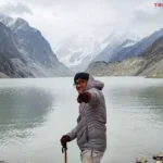
As for my own introduction to Kapuche, it happened on a whim! Our plan came together suddenly, just as Holi was approaching, right during a stretch when I was buried in tech-based work and barely looking up from screens.
It was my second trek, coming after the Tsho Rolpa Lake Trek in Dolakha, and I made some of the same amateur clothing mistakes that I thought I’d already outgrown. All three of us did, honestly. More on that in the packing section!
But here’s what I can tell you before we get into the logistics: Kapuche Lake is one of those places that gives you more than you expect and less than you hoped for, in the best possible way. Let me walk you through everything you need to know about the Kapuche Lake Trek.
Key Facts About Kapuche Lake Trek
| Alternative Name | Kahphuche Lake or Virgin Ice Lake |
| Protected Area | Annapurna Conservation Area (ACA) |
| Province | Gandaki |
| District | Kaski |
| Local Body | Madi Rural Municipality |
| Nearest Hub Village | Sikles (1,650 m) |
| Lake Altitude | Approx. 2,450 m, water level at 2,421.54 m |
| Lake Surface Area | 100,440.74 sq m (~0.1 sq km) |
| Lake Maximum Depth | 31.91 m |
| Lake Perimeter | 1,496.18 m |
| Lake Volume | 1,764,594.27 cubic meters |
| Feeding Glacier | Annapurna II Glacier |
| Lake Type | Ice/snow avalanche-formed glacial lake |
| Coordinates | 28.446° N, 84.116° E |
| Trek Duration | 2 trekking days (5 to 7 days total including travel from Kathmandu) |
| Trek Difficulty | Easy |
| Total Trek Distance (approx.) | Approx. 32 km (two-way from Sikles, including Kapuche lake) |
| Highest Point | Kapuche Lake (2,450 m) |
| Trek Starting Point | Sikles Village |
| Overnight Stop on Trail | Hugu Goth (2,070 m) |
| Network Availability | Available throughout (NTC reliable) |
| Prominent Mountains Visible | Annapurna II (7,937 m), Annapurna IV (7,525 m), Lamjung Himal (6,983 m) |
| Best Time | March to May, October to December |
| Permits Required | ACAP Permit |
| Conservation Area Permit Cost | NPR 3,000 for foreigners, NPR 1,000 for SAARC nationals, free for Nepali citizens |
Main Attractions: Why Do the Kapuche Lake Trek?
There are dozens of short treks available from Pokhara. Most of them have better-known names, more teahouses, and more established infrastructure. So why Kapuche?
Here are the actual reasons people come here, and the ones worth caring about:
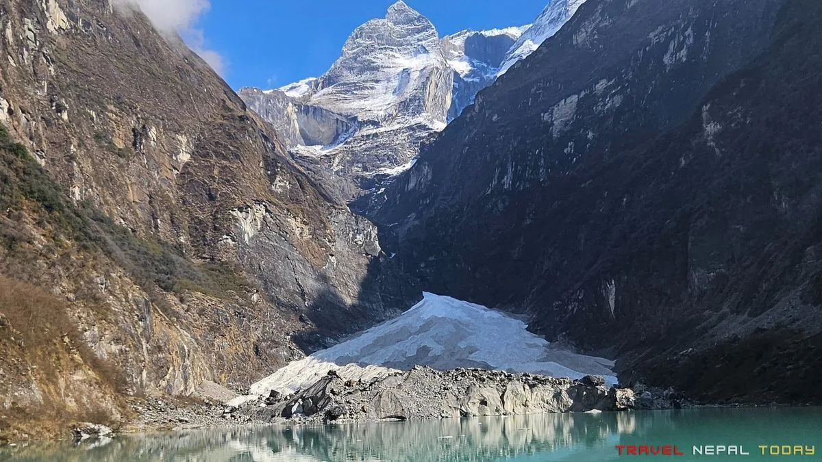
Kapuche Glacier Lake: The Reason This Trail Exists
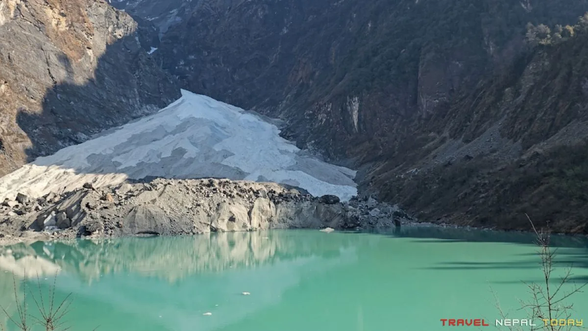
When you finally clear the forest cover above Hugu and the lake comes into view, the first thing you notice is not the color but the scale. The lake is small. Noticeably smaller than the images you may have seen online.
The surface area is just over 100,000 square meters. What makes it remarkable is its setting, not its size: a compact, turquoise-grey lake sitting in a natural bowl directly below the steep white wall of Annapurna II’s glacier, close enough that the relationship between the two is immediately obvious!
On clear mornings, the lake reflects the glacier above it in a way that makes the whole scene feel contained and almost intimate, a quality you don’t get at larger lakes. And then the weather turns, usually within 10 to 15 minutes of cloud movement, and you understand why getting there early matters.
Note that swimming is not permitted here and that’s for conservation reasons because the water is cold enough to be immediately dangerous. However, you can walk to the edge, touch the water, and sit on the sandy, muddy shoreline.
Trekkers can reach this genuine glacial environment in just two days, without the altitude adjustment that more remote destinations demand.
Sikles Village: Where the Trek Actually Starts!
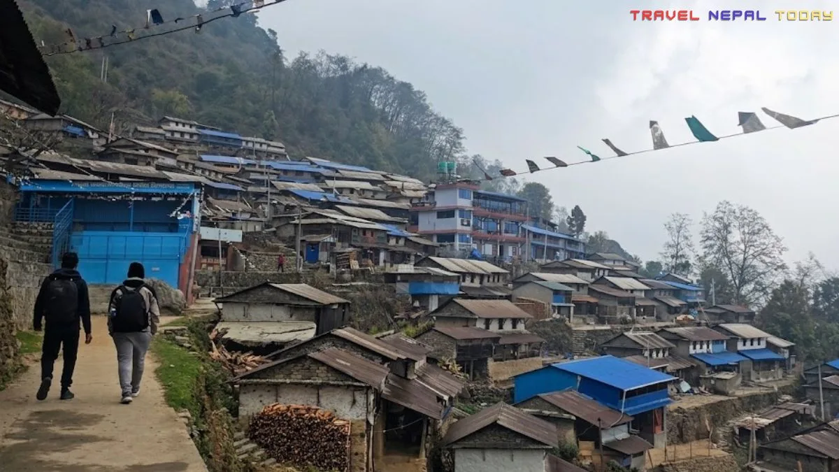
Most people treat Sikles as a transit point and move through it on the way to Hugu. I made that mistake too. If you have even a few hours here, it is worth slowing down.
Sikles is often described as one of the oldest and largest model trekking Gurung villages in Nepal, and the NTNC/ACAP maintains a dedicated Unit Conservation Office here.
Other sub-settlements here include: Dalit Basti, Gairithar, Kuithar, and Thaprang Thar.
The terraced agriculture on the hillsides, the stone-paved paths through the settlement, and the layered views of the mountains behind give the village a visual quality that photographs well even when the weather is overcast, which, during early spring in March 2024, it was for us!
The mountains were there behind the clouds. We knew it, but couldn’t get the proper views from Sikles. Next time I visit, I am spending the night here for sure!
The Gurung (Tamu Kyui) people of Sikles are deeply rooted in this landscape. Their land management practices, combined with ACAP’s conservation framework, are what keeps this region’s forest cover intact. You will notice this on the trail immediately!
People and Local Lifestyle Along the Trail
Now, let’s talk more about the Gurung people of Sikles. Well, they are part of the broader Tamu community, which is a Tibeto-Burman ethnic group indigenous to the hills of Gandaki Province.
Just so you know: according to Nepal’s 2021 census, the Gurung population nationally stands at 543,790 people, concentrated primarily in Kaski, Lamjung, Gorkha, and Manang districts. In the Kaski district itself, villages like Sikles, Ghandruk, and Bhujung represent the cultural heartland of the community!
Moreover, the Gurungs of Sikles practice a syncretic faith combining Buddhism, Bon influences, and Hindu elements. Their traditional practices, including Ghatu and Rodhi dances, local brewing of Tongba (fermented millet drink), and terraced farming on steep hillsides, are still active parts of their daily life until today.
Beyond Sikles, the trail passes through smaller hamlets and agricultural settlements where you encounter a mix of Brahmin/Chhetri and Magar communities in the lower sections.
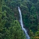
Edi Waterfall (Also Known as Gamley Waterfall)
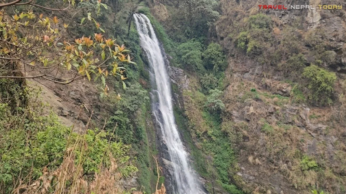
On the way up from Sikles to Hugu, the trail brings you close to a waterfall that stops most people in their tracks. The locals call it Edi waterfall (or Yedi Waterfall), and even refer to it as Gamley Waterfall.
It sits slightly off the main trail, visible but not reachable by wading into it from where you stand, which means you experience it acoustically as much as visually!
We spent almost half an hour there, just listening and taking pictures. Three people who spend most of their time on screens, suddenly having nothing better to do than stand near a waterfall in the mountains. That is the screen-to-nature ratio the trail forces on you, and it works!
During our March 2024 visit, the water flow was strong even at the tail end of winter. What it looks like during peak monsoon or the height of autumn snowmelt is something I can only imagine!
Mountains You See Along the Trail
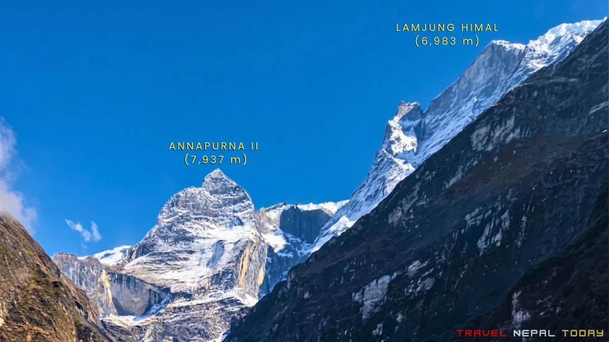
The most prominent peak from Kapuche Lake is Annapurna II, which sits directly above the glacier that feeds the lake. You cannot look at the lake without seeing Annapurna II, because the two are connected.
From Sikles itself, you get a wide panorama on clear days: Annapurna IV (7,525 m) to the left of Annapurna II, and Lamjung Himal (6,983 m) to its right.
As you gain elevation toward Hugu and then Kapuche, those same peaks get closer and the glacier face of Annapurna II becomes more defined.
We were there in early spring with a completely overcast sky on Day 1. No mountain views at all!
Day 2 cleared, and the lake visit gave us direct views of Annapurna II and Lamjung Himal.
A couple who arrived at the lake after us missed even that window! This shows that the weather moves fast here. So, starting early is the difference between seeing mountains and seeing clouds.
Forest Trails, Rivers, and Landscapes
The trail between Sikles (1,650 m) and Hugu Goth (2,070 m) runs through one of the most species-rich forest corridors in the Annapurna Conservation Area.
A floristic diversity study from the Sikles region of ACA documented 295 vascular plant species in the area.
The forest composition at these elevations includes temperate broadleaved species such as oak (Quercus spp.), alder (Alnus nepalensis) concentrated along the Madi Khola riverbank, and mixed broadleaved forests typical of the ACA’s southern flank between 1,500 and 2,500 meters.
As you gain elevation approaching the lake, the vegetation gradually transitions to denser forest with rhododendron (Rhododendron spp.) becoming more prominent.
The Madi Khola runs below and alongside significant sections of the trail, whose sound is a consistent presence in the lower sections. This river originates from Kapuche Lake’s glacial meltwater and flows south, eventually joining the Seti River near Damauli, close to Byas Gufa.
The landscape changes its character noticeably once you leave the river corridor and enter the narrower glacial valley approaching Kapuche.
One thing worth noting from our March 2024 visit:
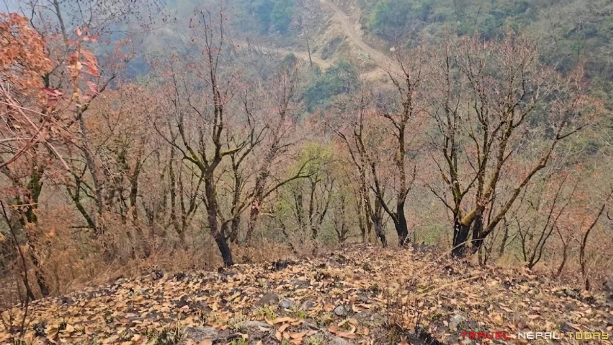
We saw clear evidence of wildfire on the trail, black burn marks and ashen ground on sections of the forest.
This is not unusual for the Kaski region. As per an April 2024 news report, that wildfire spread through the Taprang forest near Sikles, with hotel operators noting that tourist bookings had been cancelled due to smoke and obscured mountain views.
According to ICIMOD, the frequency of forest fires in Nepal has more than doubled in the last decade!
Flora and Fauna Around Kapuche
The Annapurna Conservation Area, established in 1992, covers 7,629 sq km and contains 22 different forest types, 1,226 plant species including 55 endemics, and confirmed populations of 101 mammal species.
In the southern temperate forest belt, which includes the Sikles unit, NTNC/ACAP has documented Himalayan black bear, Clouded Leopard, Leopard, Himalayan Serow, and Muntjac as characteristic species of the dense temperate forests.
Along the Madi Khola corridor and forested sections of the trail, Himalayan Musk Deer presence has also been reported. Red Panda habitat in the ACA extends through temperate mixed forests in the elevation range you are trekking through, though sightings are rare and require luck!
For birdlife, the ACA supports over 474 documented bird species. The Danphe (Himalayan Monal), Nepal’s national bird, is present in the forested sections. Satyr Tragopan and various pheasant species have also been recorded in this region.
The Madi Khola itself supports freshwater species, and the surrounding forest has significant populations of medicinal plants, including Asparagus racemosus and others used in traditional Ayurvedic and Tibetan medicine systems.
Kori Trek Extension: Worth the Two Extra Days?
Doing just the Kapuche Lake was, with the benefit of hindsight, a missed opportunity. We ran out of time because the whole plan came together last minute, and Holi was waiting in Pokhara.
But if you have an extra 2 days, the Kori Trek extension from Hugu makes the entire trip substantially more rewarding!
Kori Danda sits at 3,800 meters, accessible via the Hugu-Nohtha (Nho-ta) trail northeast of the Kapuche route. From Kori’s high meadows, the mountain panorama expands significantly: Annapurna II, Lamjung Himal, Machhapuchhre (6,993 m), and on a very clear day, even Manaslu (8,163 m) on the horizon!
The trail climbs through dense rhododendron forest before opening into alpine grassland.
Kori is located within the Annapurna Conservation Area’s buffer zone, sitting very close to the border of Kwholasothar Rural Municipality of Lamjung and Madi Rural Municipality of Kaski.
For those combining both Kapuche and Kori, the most logical route is to visit Kapuche first from Hugu, return to Hugu, and then continue toward Kori the same or following day.
We’ll have a separate, complete guide for Kori here on Travel Nepal Today. But if you are planning your Kapuche itinerary right now and have the days available, factor it in!
Getting to Sikles: How to Reach the Starting Point?
The Kapuche Lake Trek starts from Sikles village in Kaski district, approximately 40 km northeast of Pokhara. There is no direct public transport from Kathmandu to Sikles.
The standard approach is to reach Pokhara first and then find your way to Kau Khola, the departure point for vehicles heading toward Sikles.
First, Reach Pokhara
From Kathmandu, the most practical options are a tourist bus, a shared public van, a public bus, or a domestic flight. If you’re hiring a private vehicle, that’s up to you to decide.
In our case, we had boarded an evening van at around 4:30 PM and arrived at Prithvi Chowk at 12:40 AM (that was the last van, sometimes departing between 3 to 4 PM too).
If you are coming by day bus or arriving in the evening, Prithvi Chowk in Pokhara has plenty of lodging options in all budget ranges.
Amarsingh Chowk is another option closer to the departure point for Sikles vehicles, but has fewer hotel choices.
Kau Khola to Sikles: Shared Jeep or Public Bus

From Prithvi Chowk, a taxi to Kau Khola takes 15 to 20 minutes. This is where the shared vehicles to Sikles depart!
At Kau Khola, you have two options:
- A shared jeep
- A public bus, which is cheaper but takes noticeably longer.
The jeep takes about 3 hours (from our experience). The bus can take 4 to 5 hours depending on road conditions and how many stops it makes.
Since we wanted to reach Hugu the same day, we chose the jeep. That was the right call!
The bus would have pushed our arrival into darkness, which, as it turned out, we were already cutting close to even with the faster option.
The road to Sikles follows the Pushpalal Highway before diverting onto a village road that runs alongside the Bijaypur River through places like Thak, Sildujure, Chipli, and Khilang.
It is roughly 40 km from Kau Khola to Sikles. The road is paved on the Pushpalal section and unpaved thereafter, with quality varying significantly based on recent rainfall and road maintenance. After the monsoon or during spring rains, expect the unpaved sections to be rough!
By Private Motorcycle
If you are bringing your own or rented motorcycle, the route is doable, though I would remind you that you have a serious uphill trek ahead and spending several hours on rough mountain roads before that is a real energy expense.
The road does continue beyond Sikles, which can save you some trekking time, but parking security in upper sections is uncertain. Leaving the bike in Sikles itself is the better choice!
By Private Jeep
If you are in a group or have more budget flexibility, hiring a private jeep directly from Pokhara covers the 3-hour journey without waiting for the shared vehicle to fill.
Travel agencies and local jeep operators in Pokhara can arrange this for you. Pricing varies depending on negotiation, but expect significantly more than what you would pay on a shared/public vehicle.
Kapuche Lake Trek Route, Map, Distance, and Altitude
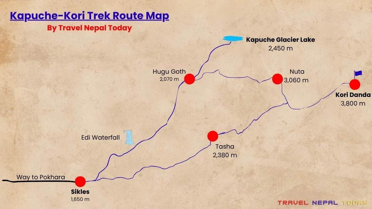
Main Stops Along the Trail
There aren’t many places you’ll stop on the Kapuche Glacier Lake Trek. Here are the only three major stops:
- Sikles (1,650 m): The starting point and cultural anchor of this trek. There is accommodation here, food options including some local Nepali specialties, and enough to keep you occupied if you arrive the day before the trek. My honest recommendation: if you have not been to Sikles before, arrive the night before and spend some time walking the settlement before you start the hike. You can leave heavier bags at a lodge/teahouse before heading up.
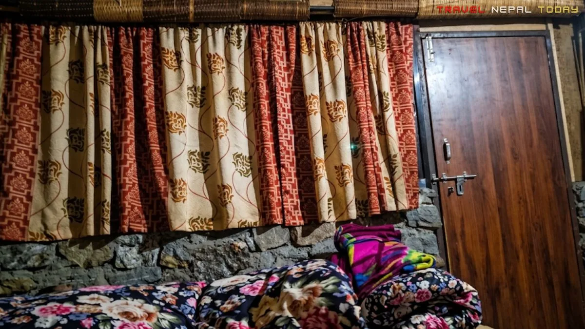
- Hugu Goth (2,070 m approx.): This serves as the overnight stop for the standard 2-day route. Hugu is small, essentially a cluster of basic teahouses at the junction of trails heading toward Kapuche and Kori. The accommodation is functional rather than comfortable. There is no proper dining room in the teahouse we stayed at, just a kitchen area with seating, and the fireplace was outside in the cold. You will be sharing the space in a very local, unpolished way. This is not a complaint but I’m just making you aware. Do not arrive expecting Ghandruk-level teahouse infrastructure here!
- Kapuche Glacier Lake (2,450 m): The final destination, where there are a few basic teahouses near the lake, which means those who start from Sikles early on Day 1 can potentially push through Hugu and reach the lake the same day. If your fitness is solid and you start early, this is possible. Otherwise, Hugu remains the logical overnight!
Distance and Walking Hours Between Different Points
| Section | Duration | Distance |
| Sikles to Karne Bhir | 1 to 1.5 hours | 3 km |
| Karne Bhir to Edi Waterfall | 30 to 45 minutes | 1.5 km |
| Edi Waterfall to Alkadanda | 1.5 to 2 hours | 3 km |
| Alkadanda to Hugu Goth | 1.5 to 2 hours | 2.5 km |
| Hugu Goth to Kapuche Lake | 2 hours | 2.5 km |
| Total Distance (one-way) | 12.5 km | |
| Total Distance (two-way) | 25 km | |
The Route Explained
Here is how the trail actually feels, section by section, based on what I experienced in March 2024:
Sikles to Edi Waterfall via Karne Bhir
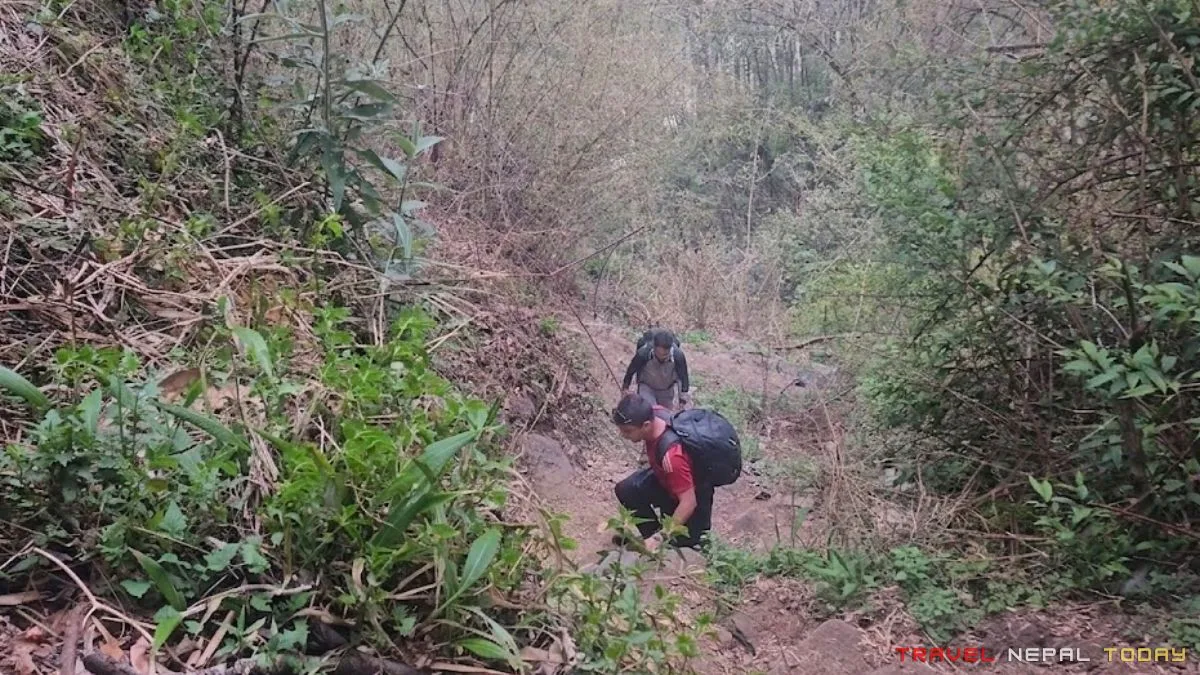
The trail out of Sikles begins with a proper climb out of the village. There is no warm-up flat section here. You leave the stone-paved streets, follow what locals call the “Kapuche Marga” trail, gain elevation above the village quickly, and then the path levels into a more straightforward traverse with the Madi Khola audible below on your right.
From Mafu in Sikles, the path heads relatively straight up to the first suspension bridge. The terrain in this section is forested, with temperate oak and alder species along the river corridor.
Our March 2024 came with very few rhododendrons (just had started to bloom), and the weather was overcast and gloomy throughout the first day. But no mountain views at all! We were disappointed about that and kept hoping the clouds would lift but didn’t!
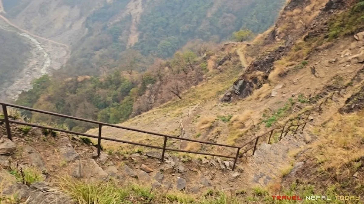
One particular section I clearly remember is the steep uphill to reach Karne Bhir which is then followed by mostly straight route towards Edi Waterfall.
Edi Waterfall to Hugu Goth via Alkadanda
After Edi Waterfall, the trail diverges: one route continues toward Hugu and eventually Kapuche, the other one is towards Kesne Danda. Make sure you take the right fork toward Hugu.
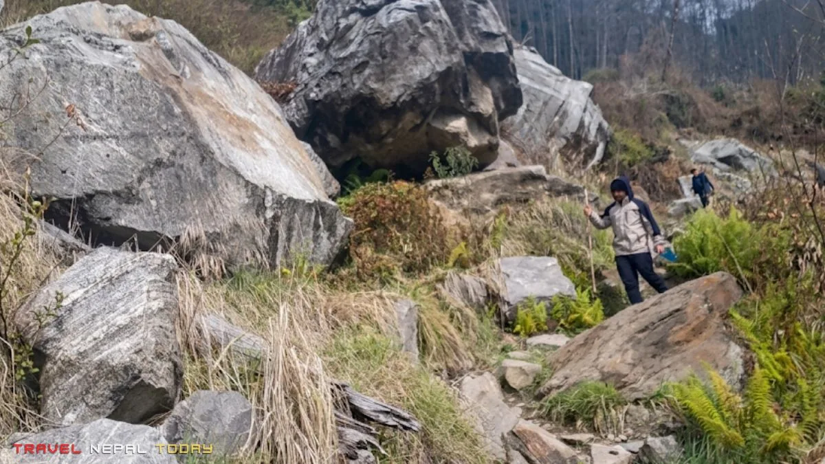
Now, the trail continues through forest, with more uphill sections and occasional flat traverses. The surface was muddy and slippery on our visit, and all three of us lost our footing at least once!
Then came the most strenuous uphill of the entire Kapuche Lake Trek: one that lead to Alkadanda. After this, it’s mosly gradual uphill and straightforard seciton.
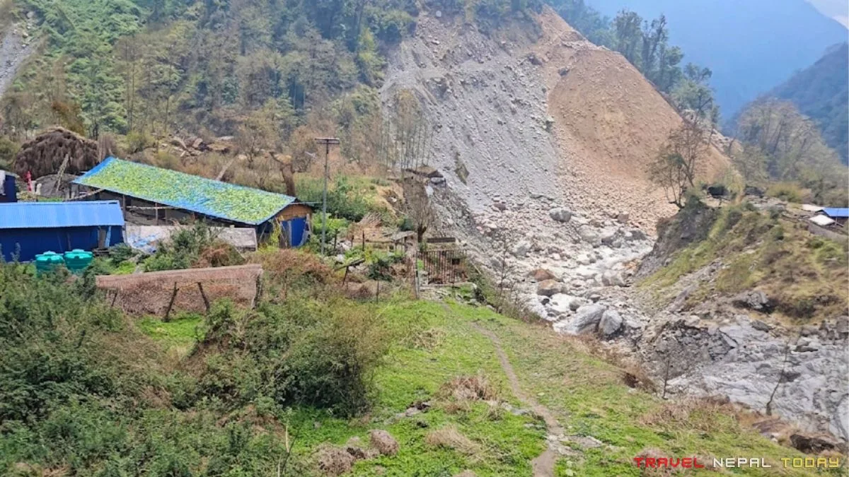
We also encountered a section that had experienced a landslide, where the trail crossed through an exposed zone. One of our group was so exhausted by this point that he essentially broke down in the middle of the landslide section and refused to move for about half an hour.
He was not in danger. He was simply finished for the day. The terrain was passable but mentally fatiguing (for beginners particularly), and by late afternoon, with daylight running short in early spring, the tiredness compounded. Not to forget, we only had noodle soup that day, which was another mistake.
After crossing the final suspension bridge, you reach the Hugu settlement!
Hugu Goth to Kapuche Glacier Lake
Day 2 started with cleared weather (very happy indeed). That matters enormously on this trek, because the lake view is entirely dependent on morning conditions.
We started early, and the 2-hour steady uphill from Hugu to Kapuche was completely forest-covered. The trail is reasonably well-marked (but in one section during return we almost lost our way), and the elevation gain is gradual enough to manage at a steady pace.
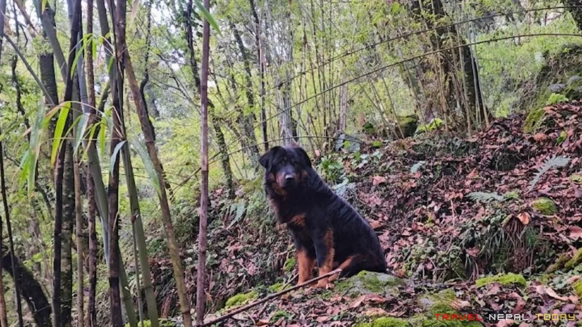
A local dog (Himalayan Sheepdog aka Bhote Kukur), whom we had named Bhotey, walked with us the entire way to the lake. I regret not having anything to feed him. He clearly knew the trail better than we did and occasionally looked back at the group with the specific expression of a dog who has done this route many times before!
We reached the lake after a considerable time. But the weather began shifting in just about 10 to 15 minutes after we arrived.
And as we were descending, we heard it: a deep, thunderous sound from above. It was a small avalanche, not visible directly from our position on our way back but audible in a way that sent everyone in the group go “whoa!” We had come for that, honestly, and we got it on the way back rather than at the lake itself.
Kapuche Lake to Sikles Return
The return is the same route in reverse, meaning the same 12.5 km total distance. Mostly downhill, which is faster but harder on knees.
One of our friends struggled significantly on this section. He has what I now recognize as a classic case of hiker’s knee (patellofemoral pain syndrome), where the downhill gradient puts repetitive strain on the knee joint.
If you have any history of knee problems, trekking poles are not optional for this route. They are essential! The descent from Kapuche back to Sikles is long enough that unassisted knees will surely complain.
Kapuche Lake Trek Itineraries
Honestly, there are multiple ways to do the Kapuche Lake Trek depending on your time, fitness, and how much of the Annapurna region you actually want to experience.
Some routes are fast and direct from Pokhara, while there’s one I have shared below that even goes higher to Kori Danda (3,800 m). Check it out below.
2-Day Kapuche Lake Trek Itinerary From Pokhara
This is the tightest option and works only for those already in Pokhara who are in solid physical shape and willing to move efficiently.
It is possible, but the Day 1 section from Sikles to Hugu is long, and you will feel it the next morning!
Day 1: Pokhara to Sikles, Hike to Hugu Goth
| Drive Distance | 3 hours |
| Drive Duration | 40 km approx. |
| Trek Distance | 10 km |
| Trek Duration | 4.5 to 5 hours |
| Elevation Gain | 420 m |
| Difficulty | Moderate |
Day 2: Hugu Goth to Kapuche Lake, Return to Sikles, Drive to Pokhara
| Trek Distance | 15 km |
| Trek Duration | 6 to 7 hours |
| Drive Distance | 40 km approx. |
| Drive Duration | 2.5 to 3 hours |
| Elevation Gain | 350 m approx. |
| Elevation Loss | 1,450 m approx. |
| Difficulty | Moderate |
3-Day Kapuche Lake Trek Itinerary From Pokhara
This is a more relaxed version for those already in Pokhara and is probably the most practical option for most trekkers who want to do this properly without rushing.
- Day 1: Pokhara to Sikles Drive, Reach Hugu
- Day 2: Hugu to Kapuche Lake, Return to Sikles
- Day 3: Explore Sikles, Return to Pokhara
3 Nights, 4 Days From Kathmandu (What We Did)
This itinerary includes travel time from Kathmandu, making it a little more rushed but still a realistic version of the trek for anyone starting from the capital.
- Day 0: Evening van from Kathmandu to Pokhara, Stay at Prithvi Chowk.
- Day 1: Pokhara to Sikles Drive, Reach Hugu
- Day 2: Hugu to Kapuche Lake, Return to Sikles
- Day 3: Explore Sikles, Return to Pokhara
- Day 4: Pokhara to Kathmandu return
4-Day Kapuche Lake Trek Itinerary From Kathmandu
This is perhaps the best way to do it from Kathmandu-to-Kapuche that keeps the structure simple and movement steady each day:
- Day 1: Kathmandu to Pokhara, Drive to Sikles
- Day 2: Sikles to Kapuche Lake
- Day 3: Return to Sikles, Drive to Pokhara
- Day 4: Pokhara to Kathmandu
5-Day Kapuche Lake and Kori Trek Combined Itinerary
This is the version I would personally recommend to anyone who has the time. Doing both Kapuche and Kori in one trip means you see the glacial lake at lower elevation and the high-meadow viewpoint at 3,800 meters without separate trips.
Day 1: Pokhara (or Kathmandu) to Sikles
| Drive Distance (Pokhara/ Kathmandu) | 40 km / 240 km |
| Drive Duration (Pokhara / Kathmandu) | 3 hours / 8 to 10 hours |
| Elevation Gain (Pokhara / Kathmandu) | 650 m / 250 m (approx.) |
| Difficulty | Easy |
Day 2: Sikles to Kapuche Lake via Hugu
| Trek Distance | 12.5 km |
| Trek Duration | 8 to 9 hours |
| Elevation Gain | 800 m |
| Difficulty | Moderate |
Day 3: Kapuche Lake to Kori Danda via Nuta
| Trek Distance | 12 km |
| Trek Duration | 7 to 8 hours |
| Elevation Gain | 1,350 m |
| Difficulty | Moderate |
Note: The Tasha (2,380 m approx.) route is comparatively more difficult, so the Hugu return and proceeding via Nuta (3,060 m approx.) keeps things manageable. That’s also the reason this 5-day itinerary focuses on
Day 4: Kori to Sikles via Hugu or Tasha
| Trek Distance (Hugu / Tasha) | 19 km / 14 km |
| Trek Duration (Hugu / Tasha) | 7 to 8 hours / 5 to 6 hours |
| Elevation Loss | 2,150 m |
| Difficulty | Easy to Moderate |
Day 5: Sikles to Pokhara (Back to Kathmandu)
| Drive Distance (Pokhara/ Kathmandu) | 40 km / 240 km |
| Drive Duration (Pokhara / Kathmandu) | 3 hours / 8 to 10 hours |
| Elevation Loss (Pokhara / Kathmandu) | 650 m / 250 m (approx.) |
| Difficulty | Easy |
Travel Tip: If you are starting from Kathmandu, add 1 to 2 days for travel at either end, making this a 6 to 7-day trip total.
How Difficult is the Kapuche Lake Trek?
The Kapuche Lake Trek can be rated “Easy to Moderate”, and that rating is accurate in the sense that there are no technical sections, no serious altitude concerns, and no requirement for specialized gear. Beginners can and do complete this trek comfortably with minor uphill hiccups!
The uphill sections on Day 1 from Sikles to Hugu are the most demanding part of the trail.
The climb to Karne Bhir in particular involves sustained steep switchbacks that feel strenuous for anyone who has not done any hill training beforehand.
Add mud and a wet trail to that, and beginners should expect to be genuinely challenged even if they are in reasonable fitness.
The descent from Kapuche back to Sikles is where knee issues become apparent. If you have any history of patellofemoral pain or general knee problems, trekking poles are not a suggestion for this trek. They are a necessity, as I mentioned earlier.
Altitude sickness is essentially not a concern here. The highest sleeping point is approximately 2,100 meters in Hugu, and even the lake at 2,450 meters is comfortably below the threshold where AMS typically begins presenting symptoms.
You may feel slightly more winded on steep uphills compared to sea-level hiking, but nothing beyond that!
The biggest physical risk factor on this trail is neither altitude nor terrain difficulty. It is poor clothing decisions. We experienced this directly!
Wearing too many layers on a steep uphill is its own kind of suffering, and the problem compounds over the course of a long hiking day.
Best Time to Visit Kapuche Lake
All seasons are technically possible for the Kapuche Lake Trek. But your experience will differ significantly depending on when you go.
The key variable for this particular trek is the avalanche activity from Annapurna II. If watching live avalanches is what you came for, February to April is when that frequency is highest.
The spring pre-monsoon period is when new snow loading on unstable ice increases the likelihood of events.
If mountain views and stable weather are the priority, October to mid-November is the best window.
If solitude matters more than anything, late November through December gives you the trail essentially to yourself.
One important note: weather windows can shift unexpectedly due to climate change and season creep, affecting the pre-monsoon and post-monsoon edges. Before departing, check precipitation forecasts for the Sikles region specifically using a reliable tool like Zoom Earth two to three days before your departure date.
Spring / Basanta (March and April)
| Factor | March | April |
| Avg Daytime Temp (Hugu level) | 10 to 16°C | 13 to 19°C |
| Avg Nighttime Temp (Hugu level) | 3 to 7°C | 5 to 9°C |
| Snowfall Probability | Very Low | None |
| Rainfall Probability | Low to Moderate | Moderate |
| Sky Condition | Partly Cloudy | Partly Cloudy to Clear |
| Visibility | Good (morning clear, afternoon clouds) | Good to Excellent |
| Trail Condition | Possible muddy sections after rain | Generally good |
| Avalanche Activity | High (best window) | Moderate |
| Verdict | Best for avalanche viewing; rhododendrons still showing in early March | Mountain views clearer; forest fully green |
Summer / Grishma (May and June)
| Factor | May | June |
| Avg Daytime Temp | 17 to 22°C | 19 to 24°C |
| Avg Nighttime Temp | 8 to 12°C | 12 to 16°C |
| Snowfall Probability | None | None |
| Rainfall Probability | Moderate (pre-monsoon) | High |
| Sky Condition | Partly Cloudy | Overcast / Rainy |
| Trail Condition | Good in May, increasingly wet in June | Slippery |
| Avalanche Activity | Low | Very Low |
| Verdict | May is quiet and green with decent visibility | June: becoming more stable because of climate change, so check weather window before going |
Monsoon / Barsha (July to September)
| Factor | July to August | September |
| Avg Daytime Temp | 20 to 26°C | 17 to 22°C |
| Avg Nighttime Temp | 14 to 18°C | 10 to 14°C |
| Rainfall Probability | Very High | Moderate to High |
| Sky Condition | Overcast / Heavy Rain | Clearing with rain patches |
| Trail Condition | Very muddy, leeches in lower forest sections | Improving |
| Avalanche Activity | Low (snow unstable but cloud cover hides visibility) | Low |
| Verdict | Not recommended | Check weather window carefully; late September can work |
Autumn / Sharad (October to Mid-November)
| Factor | October | Early November |
| Avg Daytime Temp | 14 to 19°C | 9 to 14°C |
| Avg Nighttime Temp | 5 to 9°C | 0 to 5°C |
| Snowfall Probability | None | Low |
| Rainfall Probability | Very Low | Minimal |
| Sky Condition | Crystal Clear | Clear and Cold |
| Visibility | Best of the year | Excellent |
| Trail Condition | Dry and firm | Cold mornings, otherwise good |
| Avalanche Activity | Low (glacier consolidated from monsoon cooling) | Very Low |
| Verdict | Best for mountain views; Kapuche Lake at clearest blue | Excellent with proper cold-weather layers |
Pre-Winter / Sishir (Late November to December)
| Factor | Late November | December |
| Avg Daytime Temp | 6 to 11°C | 2 to 7°C |
| Avg Nighttime Temp | -2 to 3°C | -5 to 0°C |
| Snowfall Probability | Low (possible at lake level) | Moderate at lake level |
| Trail Condition | Cold, firm | Possible frost or light snow near Kapuche |
| Avalanche Activity | Very Low | Very Low |
| Verdict | Quiet and beautiful; bring real cold-weather gear | Possible, but cold; excellent solitude |
Winter / Hemanta (January to February)
| Factor | January | February |
| Avg Daytime Temp | 0 to 5°C | 2 to 7°C |
| Avg Nighttime Temp | -7 to -2°C | -5 to 0°C |
| Snowfall Probability | Moderate at lake level | Moderate |
| Lake Condition | Partially or fully frozen surface | Partially frozen |
| Trail Condition | Cold, potential frost on steep sections | Cold but improving |
| Avalanche Activity | Moderate to High (building toward spring peak) | High |
| Verdict | Walk on the frozen lake surface is possible; good for avalanche sightings; cold but doable with proper gear | Excellent for avalanche viewing; February to April is the peak window |
Permits Required for Kapuche Lake Trek
Since Kapuche Lake falls within the Annapurna region, the main permit you need is the Annapurna Conservation Area Permit (ACAP).
The ACAP permit is mandatory for all trekkers entering the conservation area. It is checked at the Sikles entry checkpoint. Here are the cost details:
| Visitor Type | Entry Fee |
| Nepalese Citizens | Free |
| SAARC Nationals | NPR 1,000 (approximately USD 8) |
| Foreign Nationals | NPR 3,000 (approximately USD 25) |
You can obtain the ACAP permit online via the NTNC portal, or in person at the ACAP Entry Permit Counter in Pokhara/Kathmandu.
If you obtain it at the checkpost itself, note that you will pay double the standard rate. So, get it before you arrive at Sikles!
If you are booking through a travel agency or guide, they will typically handle this for you as part of the arrangement.
Talking about the Trekkers’ Information Management System (TIMS) card, it is not being enforced on the Kapuche Lake route in practice. Most trekkers and guides confirm it is not checked on this trail. However, if your agency includes it as part of their permit package, there is no harm in having it. Consider it optional unless regulations change!
And I’m answering this common question I get: Kapuche Lake is not in a restricted area, which means no Restricted Area Permit is needed.
That means you do not need to go through an agency to obtain a permit here, unlike Phoksundo Lake in Dolpa or Upper Mustang. You can do this trek independently if you choose to!
Food, Water, and Accommodation on the Kapuche Trail
Food and water on the Kapuche trail are simple, local, and very much tied to how remote the route gets as you go higher. From comfortable village stays in Sikles to basic teahouses near Hugu and the lake, things slowly strip down to essentials. Here’s what to expect at different teahosues along the trail:
- Sikles: Sikles has proper accommodation options. Multiple lodges along the main village trail offer twin or double rooms with attached or shared bathrooms. Hot showers are available. The village follows a package system where bed plus breakfast and dinner is typically bundled together; lunch is usually a separate cost.
- Hugu Goth: Hugu has a few basic teahouses offering the essentials: dal bhat, some noodle dishes, and tea. Do not expect a menu with many options. The accommodation is twin or triple sharing, rooms are basic, blankets are provided, and hot showers may or may not be available depending on the setup. The kitchen area can be small and served as the dining room. Pre-booking in Hugu is strongly recommended during any kind of peak period, because there are limited beds and no guarantee of a room if you arrive without one.
- Kapuche Lake: There are a few small teahouses near the lake. These are extremely basic, essentially seasonal shelters with minimal supplies. If you are planning to sleep near the lake, confirm in advance that accommodation is actually available during your visit dates. Most trekkers use Hugu as their base and do a day trip to Kapuche, which is by far the more reliable approach.
- Local Food/Drinks Options: Jand (locally fermented millet beer), Tongba (fermented millet drink served warm with a metal straw), buckwheat pancakes, and local vegetable preparations. Just avoid drinking alcohol before your trek (after is fine).
- Drinking Water: Boiled water is available at teahouses throughout the route. The Madi Khola provides the primary water source for the area, but do not drink directly from streams. Bring purification tablets or a filter as a backup. Carry at least 1 liter with you when leaving Hugu for the lake.
- Mobile Network: Network is available throughout the route. NTC (Nepal Telecom) is more reliable from Sikles all the way up to Kapuche. Ncell tends to be less consistent in the upper sections. And do keep in mind that weather can affect signal temporarily.
Kapuche Lake Trek Cost Breakdown
The Kapuche Lake Trek is one of the most budget-accessible multi-day treks available from Pokhara.
For Nepali trekkers, the entire trip can be done comfortably within NPR 8,000 to 12,000 per person for a 3-night, 4-day trip from Kathmandu, covering transport, accommodation, and meals.
For SAARC nationals, costs are similarly accessible, generally staying under NPR 15,000 total.
For foreign trekkers booking through a travel agency, the price range is approximately USD 350 to 500 per person for a packaged itinerary, depending on the agency, the number of days, accommodation preferences, and whether a guide is included. That package cost covers the ACAP permit, accommodation, meals, guide fees, and transport.
But if you are arranging independently (which is possible since no RAP is required), your costs drop significantly, but you take on the planning work yourself!
| Cost Component | Nepalese | Foreign (Agency-Based) |
| Transport (two-way, Ktm–Pokhara–Sikles) | NPR 2,000 to 2,500 | Included or USD 20 to 50 |
| ACAP Permit | Free | NPR 3,000 (~USD 25) |
| Accommodation with Meals (from teahouses) | NPR 3000 to 7000 | NPR |
| Guide (per day, if hired) | Not required | NPR 2,500 to 4,000 |
| Snacks and miscellaneous | NPR 500 to 1,000 | NPR 1,000 to 2,000 |
| Total Estimate (4-day trip) | NPR 8,000 to 12,000 | USD 350 to 500 (agency package) |
If you need help finding a reliable agency for this trek, fill out this inquiry form, and we’ll help you find the right fit based on your dates and budget.
Packing List for Kapuche Lake Trek
I made genuine mistakes on this trek, not going to lie. After the Tsho Rolpa experience, I thought I had learned something. But I hadn’t, not entirely, after almost two years.
I wore a high-neck base layer and fleece joggers with no proper windcheater or down jacket. I relied on the fleece as an outer layer, which made me sweat heavily on the steep uphills and then get cold immediately when I stopped.
The only good decision I made was buying a rain poncho in Sikles before starting the trek. I’ve been using it on treks for over 2 years since then! It cost a bit more than a poncho from Kathmandu/Pokhara, but it works.
I also had no trekking poles! I found a stick on the trail instead, which Bhotey stole at the lake to play with. I deserved that!
After this Kapuche Lake trek, mero balla buddi aayoI finally came to my senses and I bought proper gear for my third trek to Phoksundo. Now, here is what you should carry based on all three trips’ worth of learning:
Clothing
- Moisture-wicking base layer t-shirts (2 pieces; no cotton, no high-neck thermals for active trekking)
- Mid-layer fleece (for breaks and cool mornings, not as your outer layer on climbs)
- Light down jacket or insulated jacket (for evenings in Hugu, and cold mornings at the lake)
- A windcheater or packable shell jacket (this is what I was missing; even a lightweight one makes the difference)
- Trekking pants (synthetic, not denim, not cotton)
- Comfortable sleeping clothes separate from what you trek in
- Underwear for each day (quick-dry synthetic or merino)
Footwear
- Broken-in waterproof trekking boots. Not trail runners. Not sneakers. The trail has steep muddy sections and the descent from Kapuche is long enough that ankle support matters. All three of us slipped at least once in boots. Without boots, the slip rate would have been much higher.
- 3 to 4 pairs of wool or synthetic trekking socks.
- Camp sandals or flip-flops for use in the teahouse.
Gear
- Trekking poles. I’ve mentioned this multiple times already.
- Headlamp. We used the phone torch on the final section of Day 1 because we arrived in near-darkness. A headlamp would have been better (but still this is optional, better to plan to reach before dark).
- 30 to 40 L daypack that can carry your trail essentials while heavier bags can stay in Sikles.
- Rain cover for your pack or a quality rain poncho (buy in Sikles if needed, they have them).
- Power bank (fully charged before leaving Pokhara).
First Aid and Personal Care
- Ibuprofen or paracetamol for muscle pain.
- Knee support brace if you have any knee history.
- ORS (oral rehydration salts) packets.
- Blister treatment and plasters.
- Sunscreen and UV-protection sunglasses, especially near the lake where snow reflection increases UV exposure.
- Lip balm, hand sanitizer, basic toiletries in small travel containers.
- Any personal prescription medications.
Snacks
Stock up in Pokhara or Kathmandu. Chocolates, protein bars, nuts, dried fruit, and biscuits cover most needs. Electrolyte sachets are useful for the descent when you are fatigued and sweating. On this 2-to-4-day trek, you don’t need to carry a lot; just a few chocolate bars should be more than enough!
Tips for Responsible Trekking and Cultural Etiquette in Sikles
Here are some quick tips that will help you trek responsibly, respect local traditions, and keep the trail as beautiful as you found it:
- At the lake: Swimming in Kapuche Lake is not permitted and should not be attempted regardless of permissions. The water temperature is near-freezing, making it physically dangerous.
- In Sikles village:
- Gurung communities observe both Buddhist and traditional Bon practices. When passing mani walls or chortens, walk clockwise.
- Seek permission before photographing people, particularly during festivals or ceremonies.
- Remove footwear before entering religious structures.
- Gurung families are generally hospitable and welcoming to visitors, but that hospitality is something to respond to respectfully, not take advantage of.
- On the trail: The Annapurna Conservation Area has documented guidelines on waste management. Carry your non-biodegradable waste back out and use the dustbins at teahouses. I know even I found many plastic wrappers on the Kapuche trail myself (after reading this guide, I hope you won’t do that like other fools have).
- Wildfire zones: In spring, particularly from March to May, you may encounter wildfire-affected sections of forest. Do not light fires anywhere along the trail outside of designated cooking areas. The Kaski district has experienced significant forest fire activity in recent years, including near the Taprang area close to Sikles in 2024 I shared about earlier.
Final Thoughts
Kapuche Lake does not try very hard to impress you. The approach is simple, the lake is small, and the teahouse is simple, basic.
But the science behind that lake existing where it does is actually remarkable, and standing below the Annapurna II glacier at 2,450 meters with your boots muddy and your poncho dripping and hearing an avalanche thunder somewhere above the clouds is an experience that does not need to be bigger to matter!
I made amateur mistakes on this trek. And that’s normal as most local trekkers do on their first or second trip. You will probably make your own version of those mistakes, and that is fine. The trail handles amateurs well enough!
And if time allows at all: add Kori Danda! Go back to Sikles, stay longer, and explore more.
Happy travelling to Kaski district!