The Phoksundo Lake Trek is a remote trekking route in the Dolpa district of Karnali Province, taking you to Phoksundo Lake, one of the deepest lakes in Nepal at 136.20 meters, known for its striking turquoise color, Y-shaped body, and no aquatic life. The trek starts from Suligad, passes through traditional Bon villages along the Phoksundo Khola, and ends at Ringmo village on the lake’s southern shore.
What You’ll Find in This Phoksundo Lake Trek Guide:
- Complete overview of Shey Phoksundo Lake Trek in the Dolpa district, Karnali Province, within Shey Phoksundo National Park
- Why Phoksundo Lake is one of Nepal’s most unique destinations: turquoise color, Y-shape, no aquatic life, Ramsar site status, and Bon culture of Ringmo village
- Detailed route from Suligad to Ringmo with altitudes, distances, walking hours, and trail conditions
- Six itineraries from 7 days to 10 days via road and flight options, with full day-by-day tables
- Honest difficulty analysis: why the bus journey is equally as hard as the actual trek
- Best time to visit with all six Nepali seasons compared, including climate change effects on the trail
- All permits required: National Park entry, Restricted Area Permit, and the truth about TIMS for Lower Dolpa
- Food, drinking water, and accommodation details including what I personally experienced in Ringmo
- Packing list from my own October 2024 trek with what worked and what I’d change
- Bonpo culture, Thasung Tsholing Monastery, and the cultural uniqueness of different villages along the trail
- Flora, fauna, and wildlife that can be spotted on the trail
- Local food, Dolpa apples, Yak Sukuti, and what to avoid on the trail
- Cost breakdown for both Nepalese and foreign trekkers
- Responsible trekking tips inside Shey Phoksundo National Park
Phoksundo Lake had been sitting on my bucket list for two years before I finally went. Not because I wasn’t interested. The interest was always there. It was the confusion that held me back.
I’d heard stories about switching vehicles like a relay race, taking two flights that might not even be available on the same day, and wondering whether the road had even reached that far yet.
But then I found out there was a direct bus from Kathmandu to Dolpa. That changed everything!
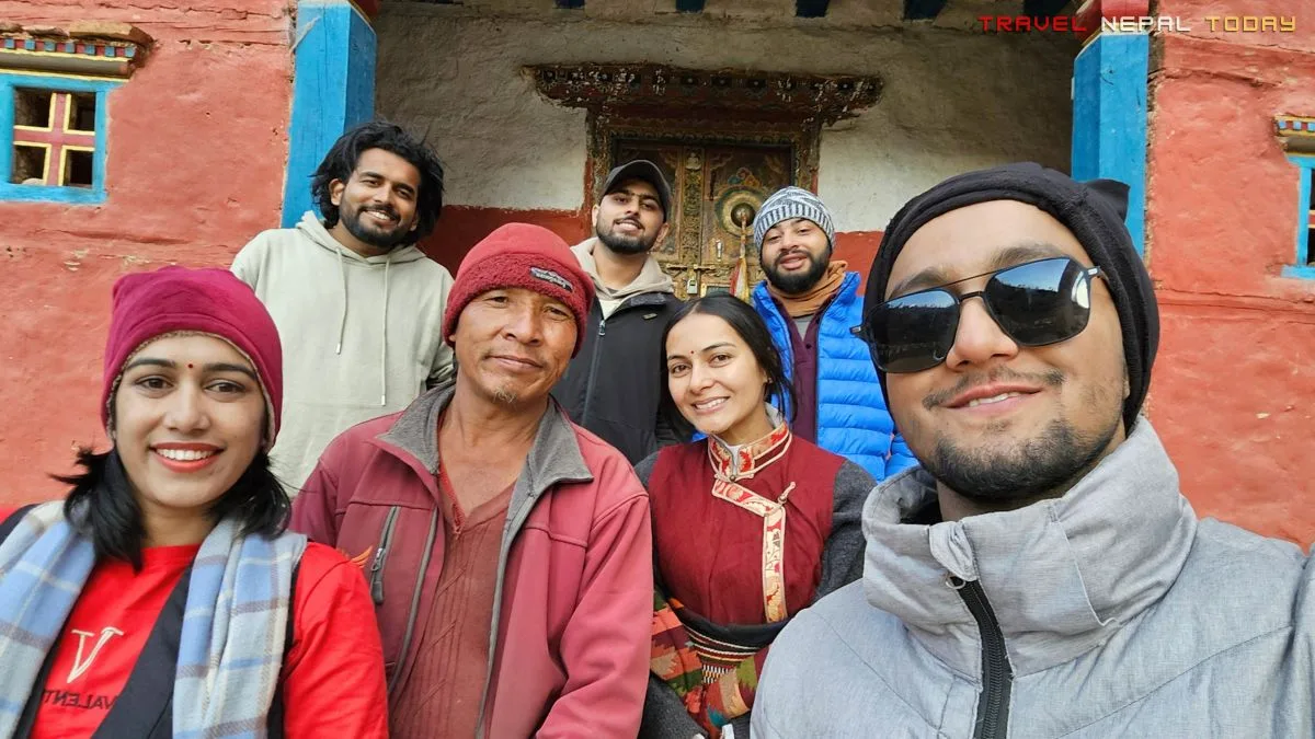
My friends and I completed this trip in 8 days, and honestly, it became one of those experiences you keep returning to in your head long after you’re back home.
We started as four. By the time we reached Ringmo, we were nine. That’s the Phoksundo effect on you. People find each other here.
This guide covers everything: transport, route, itinerary, permits, accommodation, food, culture, and the actual on-ground reality that most generic guides skip over entirely.
Everything written here is based on what I researched, what I experienced, and what I’ve learned from the readers and commenters who’ve been asking questions on this blog since this article first went live.
So if you’re planning the Phoksundo Lake Trek, stick with me until the end!
Key Facts About Phoksundo Lake Trek
| Lake Names | Phoksundo or Phoksumdo Lake (Tsho Karpo / Rigmo in local Tibetan dialect) |
| Protected Area | Shey Phoksundo National Park |
| Province | Karnali |
| District | Dolpa |
| Local Bodies | Thuli Bheri Municipality, Shey-Phoksundo Rural Municipality |
| Lake Altitude | 3,611 m |
| Lake Max Depth | 136.20 m (source) |
| Lake Surface Area | 4.94 sq km (494 ha) |
| Max. Altitude (Viewpoint) | 4,045 m |
| Highest Sleeping Altitude | 3,640 m approx. (Ringmo Village) |
| Trek Duration | 7 to 10 days |
| Trek Difficulty | Easy to Moderate |
| Accommodation Type | Teahouses |
| Network Availability | From Saaijol onwards (NTC reliable) |
| Charging Availability | Available throughout route |
| Main Mountains Seen | Norbung Kang (6,005 m), Jhyarko Dingla (5,850 m), Kanjiroba Himal (6,883 m), Kanchauni (6,444 m), Lhashamma (6,412 m) |
| Peak Season | October, November, March, and April |
| Best Time | March to May and October to November |
| Permits Required | Shey Phoksundo National Park Permit, Restricted Area Permit (RAP) for foreigners, TIMS (optional) |
| Main Ethnic Group | Dolpo-pa (Tibetan origin), Bonpo faith [Lama, Baiji, Gurung, Magar, Brahmin/Chhetri] |
| Total Trek Distance (approx.) | 75 km (two-way from Suligad including viewpoints and monastery visit) |
Why Choose Phoksundo Lake Trek?
There’s no shortage of trekking destinations in Nepal, so the question is worth asking: what makes Phoksundo Lake special enough to spend 8 to 10 days getting there and back?
Here’s the honest answer in short:
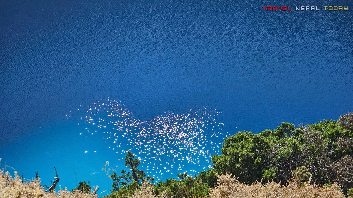
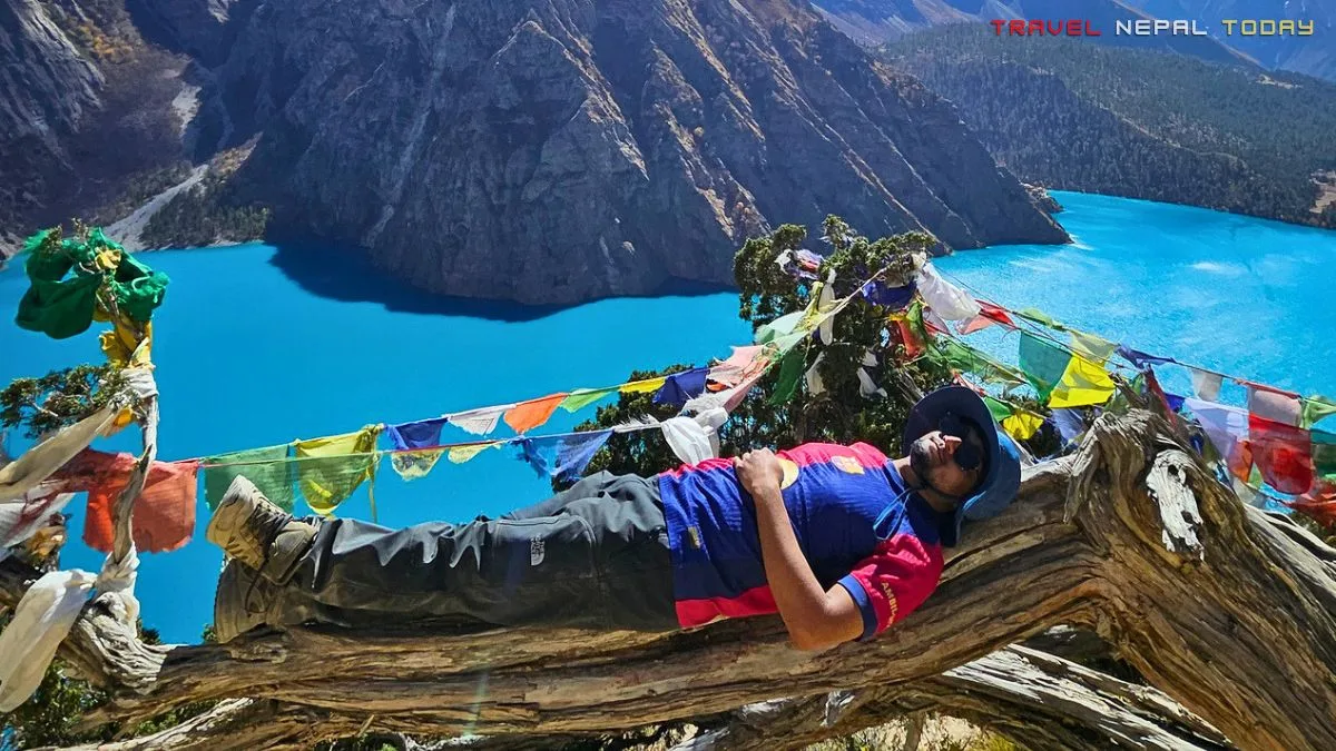
- The lake’s color is genuinely unlike anything else in Nepal. Shey Phoksundo Lake is turquoise, sometimes deep charcoal blue in low morning light, sometimes a vivid cyan by noon. The color shifts throughout the day depending on light, cloud cover, and angle. I watched it change from charcoal blue at dawn to a bright aquamarine by 10 AM, and I wasn’t prepared for how striking the difference was.
- It’s one of the deepest lakes in Nepal. At 136.20 meters deep, the water clarity is exceptional partly because there is no aquatic life. No fish. No algae. The lake looks almost artificial in its clarity, but there it is, in one of the most remote corners of the Himalayas.
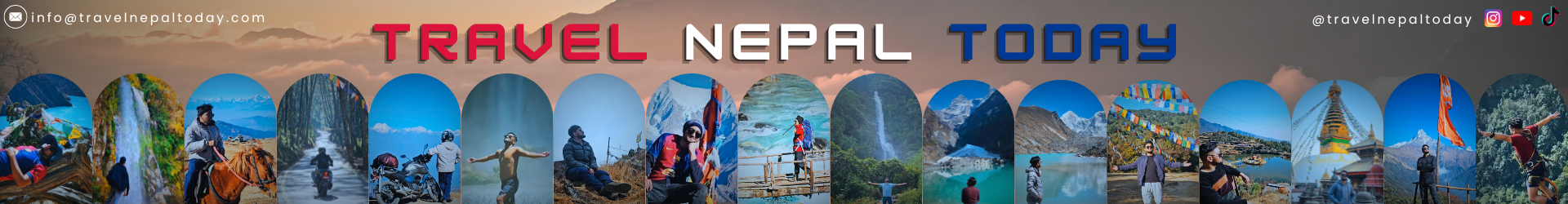
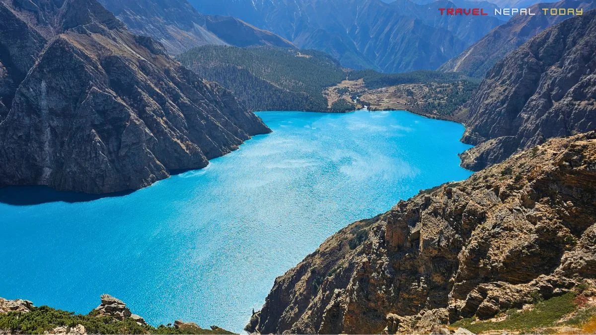
- The Y-shape is something you have to earn. You only see the full Y-shape from the third viewpoint or higher. Most people who just visit the lake and return never actually see it. That Y-shape is what the lake’s name “Phoksundo” (from the Tibetan word “Phokso” meaning lungs) references. Two channels meet at the lake, one from Phoksundo Khola and one from Sagar Khola, creating those two upper arms.
- The Bon culture of Ringmo village is rare and living. This isn’t a cultural museum. People actually live here, practice Bon religion in its purest form, herd yaks, grow barley and buckwheat, and engage in trade routes that predate modern Nepal by centuries. The Thasung Tsholing Gompa above the lake was built about 900 years ago!
- Remoteness that actually delivers. A lot of treks in Nepal promise remoteness and then deliver a packed trail. Phoksundo genuinely filters its visitors by distance. The 30-hour bus ride or the multi-flight approach naturally ensures that people who make it here actually wanted to be here.
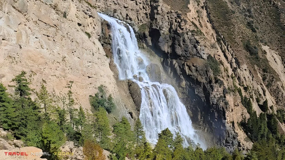
- The Phoksundo or Suligad waterfall, formed by the lake’s outlet dropping 167 meters, is perhaps among one of the highest waterfalls in the Dolpo region. You can’t bathe in it from the trail, but the sight of it with its occasional rainbow arc stopped our entire group for almost an hour!
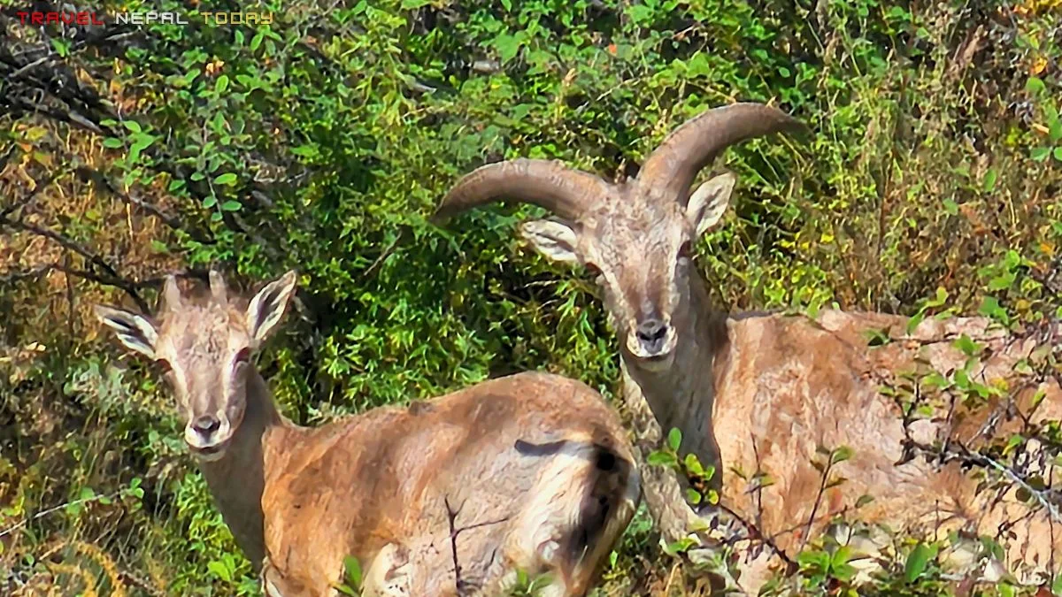
- The wildlife is real. My friends spotted a Red Panda on the trail. We saw Himalayan Thar multiple times. The Shey Phoksundo National Park, with 90 documented snow leopards (as per DNPWC study, 2023), is one of the most important snow leopard habitats on earth. You won’t see a snow leopard on the Phoksundo Lake Trek route specifically, but you’re walking in their territory.
Main Highlights of the Phoksundo Lake Trek
Before I break things down properly, let me highlight the major attractions of the Phoksundo Lake trek. It’s a collection of small wins, unexpected views, and a final reward that slowly builds as you move deeper into Dolpo:
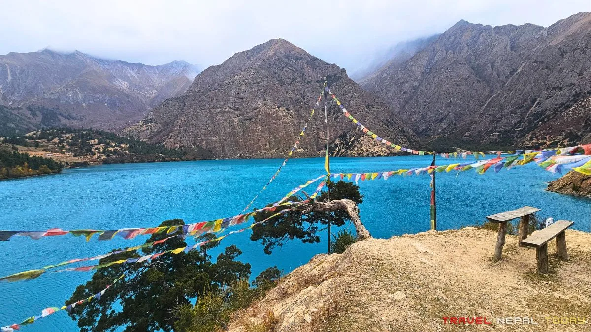
Phoksundo Lake: The Centerpiece of Everything
When you finally get your first proper view of Phoksundo Lake, everything you went through to get there makes complete sense.
I ran straight to the lakeshore the moment I got there. Shoes and socks got wet. My head went in the water. I’m not apologizing for any of it.
The lake sits at approx. 3,611 m and holds water that is completely crystal clear, cold enough to make your hands numb in seconds, and a color that honestly looks photoshopped even when you’re standing in front of it!
A quick clarification people often ask about: Phoksundo and Phoksumdo are two spellings of the same lake. You’ll see both used widely.
The official name as per national park records is Phoksundo Lake, though locals in Ringmo refer to the village as Tsho-wa meaning “lakeside village” and the lake area as Rigmo.
You can touch the water, sit by it, and take your time. You cannot swim in it as it’s a high-altiude Ramsar site (designated September 2007) and a national park. The water is sacred to the Bonpo community. Please respect that!
The lake was formed by a massive post-glacial landslide estimated to have occurred around 40,000 years ago. That landslide blocked the Suligad valley, and water accumulated over millennia. And Ringmo village itself sits on this landslide dam!
The Phoksundo Lake Viewpoints
This is where most guides get lazy, and I want to fix that.
There is no official viewpoint system at Phoksundo yet. No numbered boards, no marked paths with arrows saying “1st viewpoint, 500 m ahead“, or something like that. Our group essentially named the viewpoints ourselves as we climbed.
What I can tell you from experience is this:
- The trail starts from Ringmo, heading up a steep spur to the north. It’s steep enough to make you work for it, especially first thing in the morning.
- The first point with a proper rest area, a large flat rock, and a tree is what most people call the “first viewpoint.” The photos you see online of someone sitting against a tree with the lake below? That’s this one!
- From there, the trail continues upward. There’s a second more open viewpoint along the way.
- Then a third one on a high cliff, where the full Y-shape of the lake finally reveals itself if you’re high enough and the angle is right (just a basic glimpse, not the whole lake).
I went even further with one of my friends and we found our own spot, which we named the “fourth viewpoint.” Another of my friend went further still and reached the opposite side of the lake, which is a quieter, more peaceful section that most trekkers skip entirely!
And before reaching the first viewpoint, I even marked one as ‘Bhishu’s Viewpoint’. Hehe.
One important note: the winds pick up significantly by afternoon in this area. Start the viewpoint hike early in the morning, ideally by 6 to 7 AM, and aim to be descending before noon.
This is also the same trail that leads further into Upper Dolpo toward Shey Monastery, for those doing a longer circuit.
Main Villages Along the Trail
The trail from Suligad to Ringmo passes through several villages, each with its own character worth noting briefly:
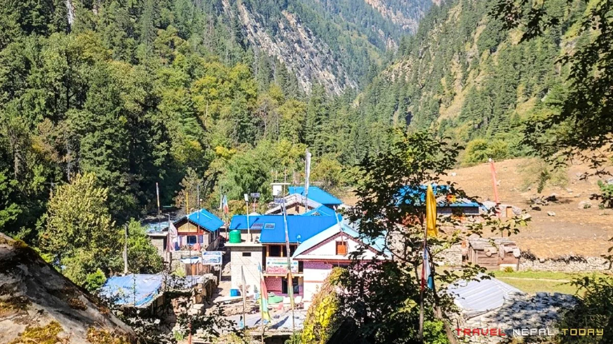
- Chhepka (2,760 m): A proper lunch village. Multiple teahouses, reliable food options, and good energy from the locals. It sits in a relatively sheltered section of the valley with lush vegetation around it. This is where our group had Dal Bhat and time-lapse lunch.
- Renchi/Rechi/Riyachi (3,120 m): Smaller than Chhepka but a common stopping point for those doing a two-day lower section. Basic accommodation is available here. The Phoksundo Khola valley starts feeling more dramatic from this altitude onward.
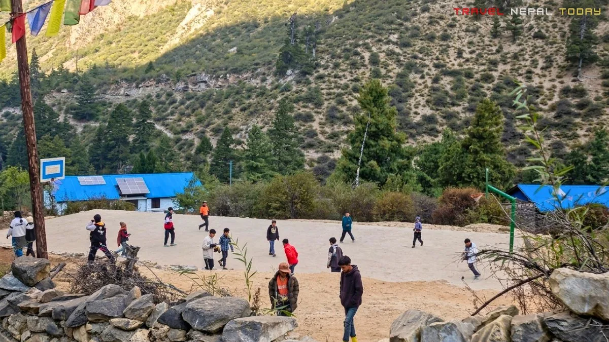
- Saaijol/Tapriza (3,130 m) and surrounding hamlets: This cluster of small settlements including Samjhana Hotel (Bagral), Jharana Hotel (Chunuwar), and Tapriza (or Saaijol, popular hotel: Shey Karnali) itself has become so identified by the hotel names that locals use them as landmarks. There’s even a secondary school here, Tapriza Secondary School, and Saaijol Health Post. This was our overnight stop before reaching Ringmo.
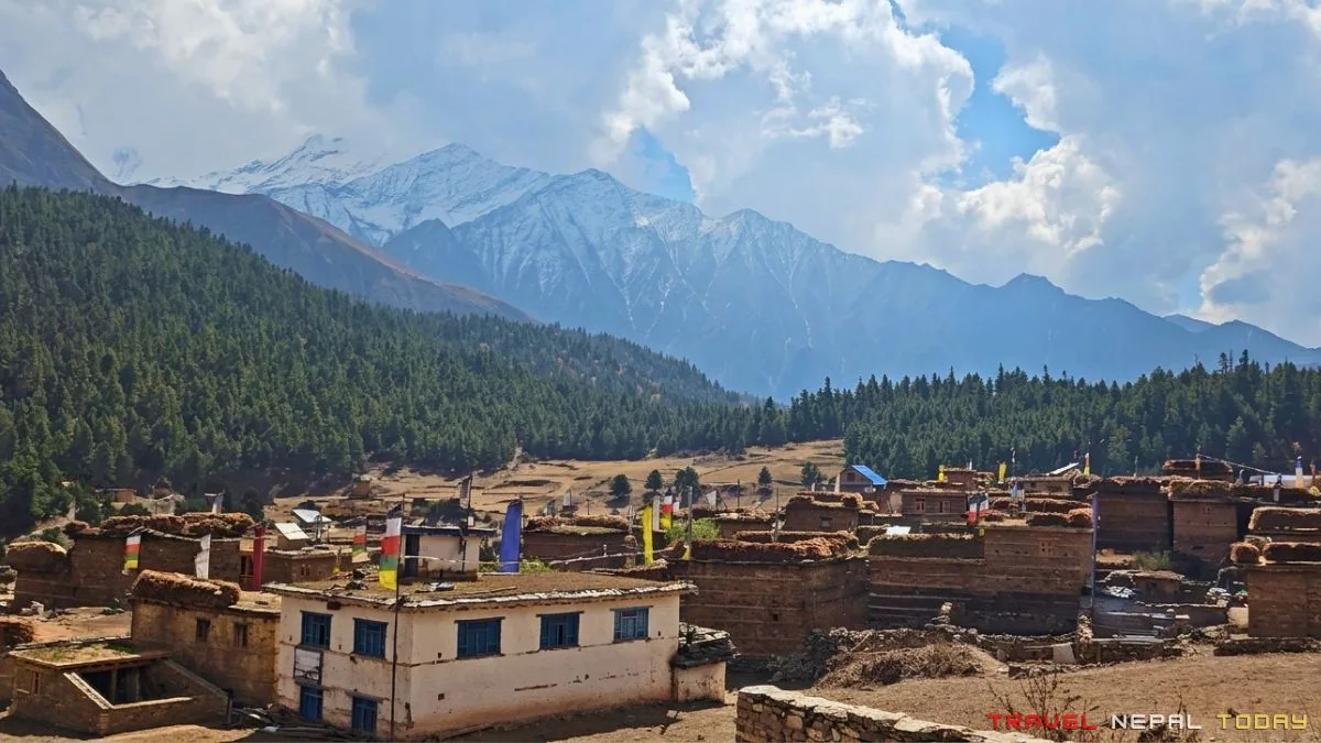
- Ringmo aka Ryangba (3,640 m): Locally called Tsho-wa (meaning lakeside) or Ryangba, the 1,000-year-old Ringmo Village on the shores of Phoksundo Lake marks the final destination of the trek. It is home to a community of Tibetan descent deeply rooted in the ancient Bonpo faith. The village features traditional 2-to-3-story flat-roofed, rammed-earth houses built with solid rear walls to brave the cold wind. Perched just above on a spur overlooking the water is the 15th-century Thasung Tsholing Gompa. This is where you stay, explore, and spend as much time as the lake allows.
The Bonpo Culture and People of Ringmo
This is something I want you to understand before you arrive, not after you leave.
The Bon religion is not Buddhism. It is not a variation of Buddhism. It is an entirely separate spiritual tradition, one that predates the arrival of Buddhism in Tibet.
Its origins trace back to the Zhang Zhung kingdom in western Tibet, where it was the dominant faith before the 8th century. When King Trisong Detsen of Tibet patronized Buddhism and began suppressing Bon, many Bon practitioners fled south into the high valleys of Nepal. The Dolpo region in western Nepal became one of their sanctuaries!
The people of Ringmo are majorly Dolpo-pa of Tibetan ethnic origin. They follow the Yungdrung Bon tradition, the most organized and ancient branch of the faith.
Their deep reverence for nature is not incidental to their religion. It’s central to it!
The Thasung Tsholing Gompa (a bon monastery) was specifically founded centuries ago to stop the practice of hunting local wildlife by chasing animals off cliffs. “Thasung” in Tibetan means “protected cliff” and “tso” means lake. You see, the monastery’s very name speaks to conservation!
This Bon Gompa above the lake was built approximately 900 years ago and is one of the most active Bon religious sites in the entire Dolpo region. It is a cluster of nine private monasteries and one community gompa, maintained under the spiritual leadership of the Menri tradition.
Inside, you’ll find small statues, thangka paintings, and the kind of stillness that takes a few minutes to settle into.
The main occupations in Ringmo are agro-pastoralism (barley, buckwheat), yak herding, and increasingly tourism. Yak caravans still operate, though the traditional salt trade routes from Tibet have declined significantly due to modern transport and changing economies.
Other ethnic groups you’ll encounter along the trail before reaching Ringmo include hill Brahmins, Chhetri, Magar, and Gurung communities in the lower sections. The trail is ethnically diverse in a way that upper altitude treks often are not.
Festivals in the Phoksundo Region
The main festivals celebrated in Ringmo and the surrounding Bonpo communities reflect the Yungdrung Bon calendar rather than the Hindu or Buddhist Nepali calendar.
- Chotrul Duchen (first month of the Bon lunar calendar): A festival of miracles commemorating Tonpa Shenrab Miwo, the founder of Bon. Celebrated with prayers, offerings, and community gatherings.
- Shey Festival (held at Shey Gompa, Upper Dolpo, every 12 years during the Year of the Horse): This is one of the most significant pilgrimage festivals in the entire Dolpo region. Thousands of devotees travel to Shey Gompa. If your timing aligns, it is a rare and extraordinary event to witness. The next occurrence is worth researching before planning your trip.
- Losar (Tibetan New Year): Celebrated in Ringmo with traditional dances, songs, and community prayers. The timing varies by the Tibetan lunar calendar but generally falls in February or March.
- Drubchen: A multi-day Bon ritual ceremony that involves continuous prayer and is considered one of the most powerful collective spiritual practices in the tradition.
In addition, the harvest season in late autumn brings informal celebrations tied to the buckwheat and barley harvest, which are the primary crops of the region.
Flora and Fauna of Shey Phoksundo National Park
This is one part of the trek that quietly happens in the background, but once you start noticing it, the entire trail feels more alive!
Wildlife Along the Route
In our group, two friends spotted a Red Panda on the forested trail between Kageni and Chhepka. It moved quickly and disappeared into the bamboo undergrowth. If you see one, consider yourself lucky!
Blue sheep (bharal) are the most commonly spotted large mammal along this entire route. They’re often seen grazing on rocky slopes above Renchi and Saaijol, and luckily we spotted a few ones too!
And as I mentioned earlier, Shey Phoksundo National Park also has snow leopards, but spotting them is almost impossible in this lower Dolpo region.
Other mammals along the route include Musk Deer, common Langur, Himalayan Tahr, and Marmots.
For birds, the Danphe (Himalayan Monal, Nepal’s national bird) is possible in the forested sections. Tibetan Partridge, Snow Cock, and Crimson-eared Rosefinch are present in the higher sections. Over 200 bird species have been recorded in the Shey-Phoksundo National Park.
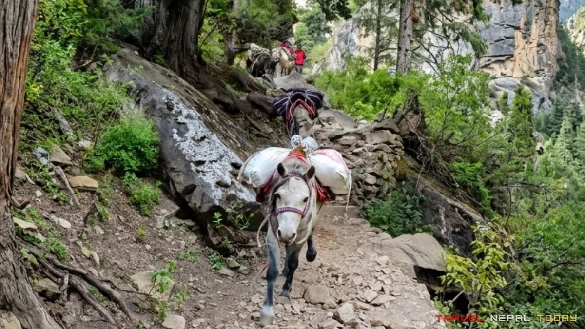
Also, Yak caravans are still a feature of the Dolpo landscape, especially higher up. You’ll encounter yaks, dzo (yak-cattle hybrids), horses, mules, and donkeys on the trail. Give them right of way (don’t stand in the cliff-side).
Flora Along the Route
The lower Suligad valley (2,060 to 2,500 m) is dominated by Blue Pine, Rhododendron, Silver Fir, Hemlock, Spruce, Bamboo, and Poplar. This is the forest section of the trail, generally from Kageni through Chhepka.
As you gain altitude toward Saaijol and higher, the vegetation shifts to Juniper, White Himalayan Birch, and Rhododendron. The higher ground around Ringmo and the viewpoint route features alpine meadows with edelweiss, gentians, and primroses.
The park also contains over 286 species of flowering plants of ethnobotanical significance, many used in traditional Tibetan medicine.
The Dolpo region is particularly noted for Yarshagumba (Caterpillar Fungus, Ophiocordyceps sinensis), which has become a major economic resource for local communities. You’ll likely see people harvesting it in the right season (late May to mid-June).
Local Food and Drinks to Try
Food on this trail isn’t just about eating. It’s about adapting to the place, trying what’s available, and sometimes just enjoying the moment with whatever you get. Here are the local ones that you must try:
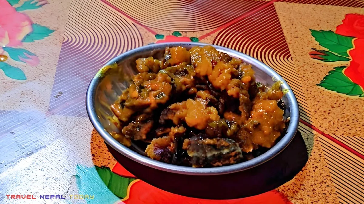
- Yak Sukuti: Dried yak meat, often cold or slightly warmed, and available in most teahouses from Chhepka onwards. It has a strong, gamey flavor and it’s worth trying at least once. Our group had it in Ringmo and Saaijol. One of own members tried cuting slides with a khukuri too (it was worth an experience). Eat it for the experience rather than as a primary nutrition source (because meat in high-altitude is a differnet story, which I’ll write another article about).
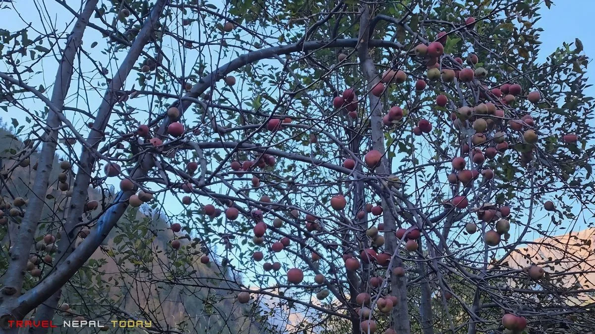
- Dolpa Apples: Apple trees grow particularly near Renchi. During the right time, you can pick apples directly from roadside trees (so did we in October, after seeking permission). We also bought a full crate from Dunai Bazaar to take back. These apples are smaller and more tart than what you find in supermarkets, and they’re genuinely excellent!
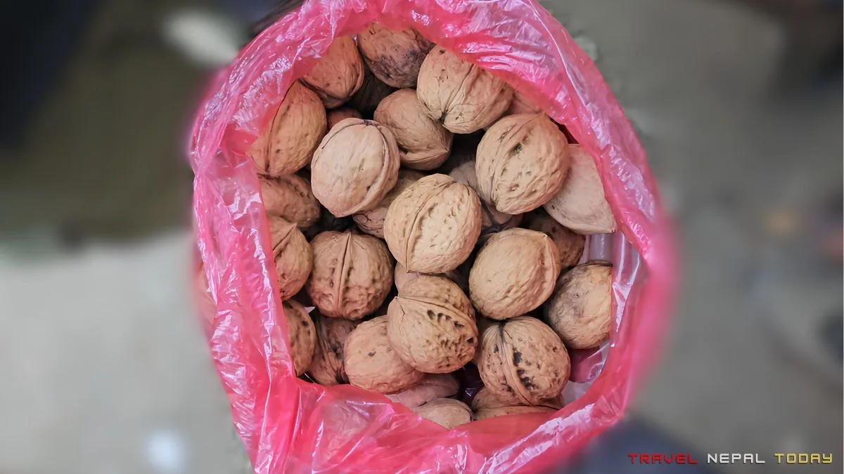
- Dolpa Walnuts: Also available in Dunai Bazaar and sometimes along the trail (in Kageni).
- Local Raksi and Tongba: Local alcohol is available in Dunai and sometimes in trail teahouses. In our final night in Dunai, Tongba (fermented millet drink served in a wooden vessel with a straw) was our celebratory drink. It’s warm, slightly sour, and perfect for a cold evening.
Caution: Alcohol affects you more strongly at higher altitudes. If you’re still in the higher sections, I’d recommend not consuming alcohol until you’re back at Dunai.
Reaching the Starting Point: Bus and Flight Details
The starting point for the Phoksundo Lake Trek is Suligad (2,060 m), which serves as both the national park entrance and the trailhead.
One of the questions that has come up constantly in the comments on this blog, and is genuinely the most-searched question about this trek, is: how do you get to Dolpa? Let me give you the complete picture:
By Road: Kathmandu to Suligad
This is what we did, and despite the 30-hour duration, it is genuinely the most direct option for Nepalese and budget travelers.
There is a direct bus from Kathmandu to Dunai/Dolpa:
- The service operates from Machhapokhari Bus Park in Kathmandu and departs at 11 AM daily.
- The fare is approximately NPR 6,000 per person as of our trip.
- If you’re from Pokhara, you can board the same Dolpa-bound bus midway at Pokhara for a slightly lower fare (approximately NPR 5,500).
| Route (via Baglung) | Kathmandu > Pokhara > Baglung > Burtibang > Kankri > Rukumkot > Rimna > Athbiskot > Tallobagar (or Tallu Bagar) > Tribeni Bazar > Tripurakot > Rupagad > Suligad |
| Total Distance | 630 km approx. |
| Duration | 30 hours approx. |
| Districts Crossed | Kathmandu > Dhading > Chitwan > Tanahun > Kaski > Parbat > Myagdi > Baglung > Rolpa > Rukum East > Rukum West > Jajarkot > Dolpa |
| Fare | NPR 6,000 approx. |
An alternate road route exists via Kohalpur (the Chhinchu-Jajarkot-Dunai Highway), which merges with the Pushpalal Highway route at Rimna. From Nepalgunj or Birendranagar, here’s what the route looks like:
| Route (Kohalpur) | Nepalgunj/Birendranagar > Kohalpur > Birendranagar > Chhinchu > Bhotechaur > Syanipipal > Rimna (connects with Pushpalal Highway) > Dunai > Suligad |
| Nepalgunj to Suligad Distance | 270 km approx. |
| Birendranagar to Suligad Distance | 225 km approx. |
| Duration | 10 hours approx. |
Note: The Dolpa road is challenging. After heavy monsoon or landslides, vehicles sometimes can only reach as far as Tallobagar, and from there, it’s either wait for the road to clear, change to a 4WD, or begin trekking earlier than planned. Always check road conditions before your journey, especially June through early October.
By Flight: Multiple Options
For international trekkers or those with limited time, flights significantly cut the travel time, though they also significantly raise the cost.
| Route | Duration | Notes |
| Kathmandu to Nepalgunj | 55 minutes | Multiple daily flights |
| Nepalgunj to Juphal | 45 minutes | Small aircraft, weather-dependent |
| Kathmandu to Surkhet (Birendranagar) | 60 minutes | Less common but available |
| Surkhet to Juphal | 40 minutes | Via small aircraft (weather-dependent) |
Juphal Airport is one of Nepal’s highest and most challenging domestic airstrips. Flights are heavily weather-dependent and cancellations are common. So, you’ll need to allow buffer days on either side of your Juphal flight.
From Juphal airport to Suligad is 6.5 km, approximately 2 hours on foot or a short 30-minute jeep ride.
For those combining both modes: fly to Nepalgunj or Surkhet and then take a jeep or bus to Dunai from there, which is a significant time and cost saver compared to the full road journey from Kathmandu.
Phoksundo Lake Trek Route, Map, and Altitude
The trek follows the Suligad River followed by Phoksundo Khola from Suligad all the way to Ringmo. The path is mostly straightforward because the river guides you.
There are no major navigational challenges except the steep section from Polam to Ringmo.
Let’s break down everything here to give you a clear understanding of Phoksundo Lake’s route.
Phokusundo Lake Trek Map
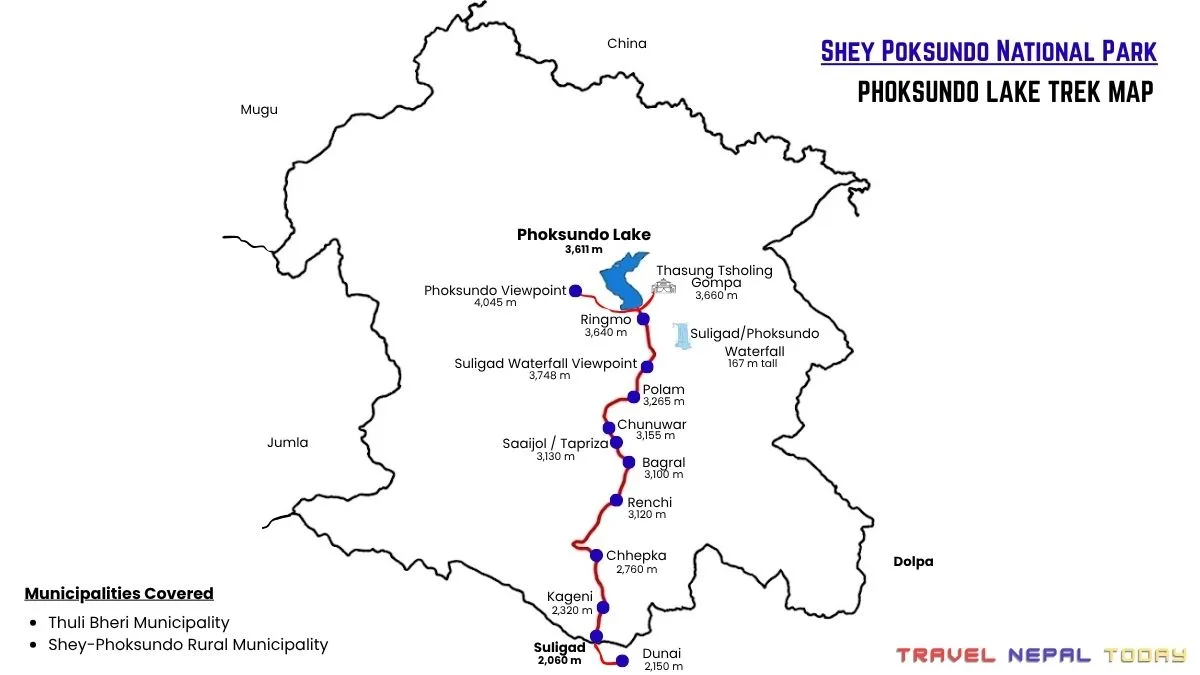
Route Breakdown with Altitude
| Segment | Distance | Duration | Notes |
| Suligad (2,060 m) to Kageni (2,320 m) | 5.5 km | 3 hours | National park entry, landslide-prone section |
| Kageni to Raktan (2,270 m) | 200 m | 5 minutes | Very short connector |
| Raktan to Shyagda (2,480 m) | 4 km | 2 hours | Forest trail, wooden bridges |
| Shyagda to Chhepka (2,760 m) | 2 km | 2 hours | Junction of Phoksundo Khola and Majab Khola |
| Chhepka to Renchi (3,120 m) | 8.5 km | 4 to 5 hours | Longest single segment, multiple bridges |
| Renchi to Sanduwa (3,110 m) | 3 km | 1.5 hours | Yulun Khola joins here |
| Sanduwa to Bagral/Samjhana Hotel (3,100 m) | 1 km | 30 minutes | Mobile network is available from here onwards |
| Bagral to Saaijol/Tapriza (3,130 m) | 600 m | 20 minutes | School and health post here |
| Saaijol to Chunuwar/Jharana Hotel (3,155 m) | 600 m | 15 minutes | You can pick any location for the night stay |
| Chunuwar to Polam (3,265 m) | 1 km | 1 hour | The easy section before the steep climb arrives |
| Polam to Phoksundo Waterfall Viewpoint (3,748 m) | 2 km | 2.5 hours | Steepest section of the entire trek |
| Waterfall Viewpoint to Ringmo (3,640 m) | 3 km | 2 hours | Slight descent to the village |
| Ringmo to Thasung Tsholing Gompa (3,660 m) | 1 km | 30 minutes | Many miss it, you don’t! |
| Ringmo to Phoksundo Lake Viewpoints (up to 4,045 m) | 3.5 km | 4 hours (round trip) | Start early morning |
Total two-way distance from Suligad (including monastery visit and viewpoints): approximately 75 km.
Trail Character Section by Section
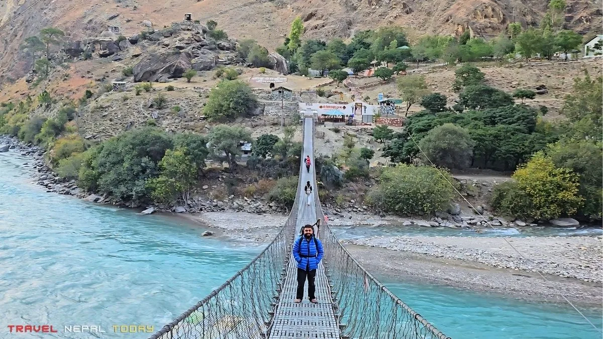
The trek begins after crossing Bhim Bridge, a suspension bridge over the confluence of Suligad and Thuli Bheri rivers. Shortly after, you reach the national park entrance where permits are checked.
The route from the national park entrance all the way to Chhepka follows the Suligad River, then transitions to following the Phoksundo Khola in Shyagda. The trail is mostly flat to moderately inclined, with the river always nearby.
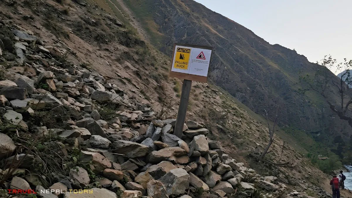
Before Kageni, there is a landslide-prone section. Do not linger here. Rocks do fall, particularly in the afternoon when winds pick up. We crossed this section in the afternoon and a rock fell very close to our team. We had to split into pairs and ran across.
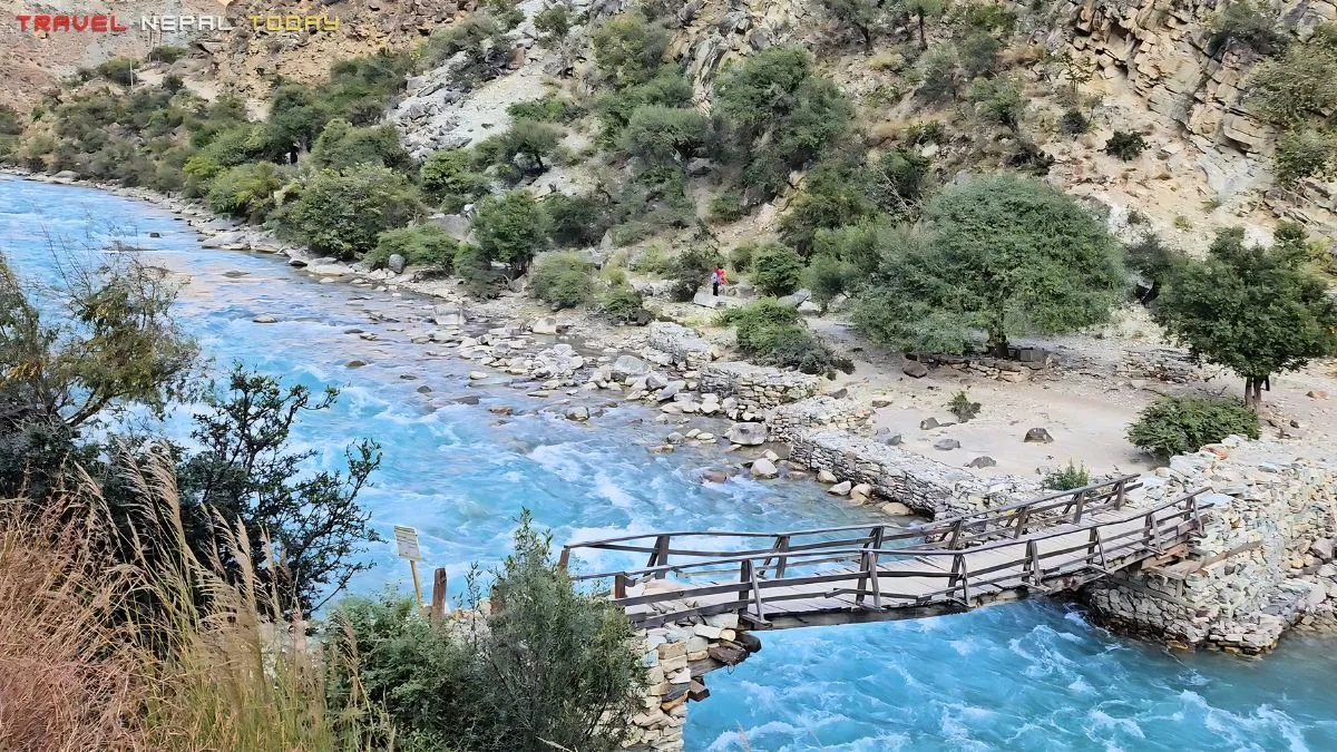
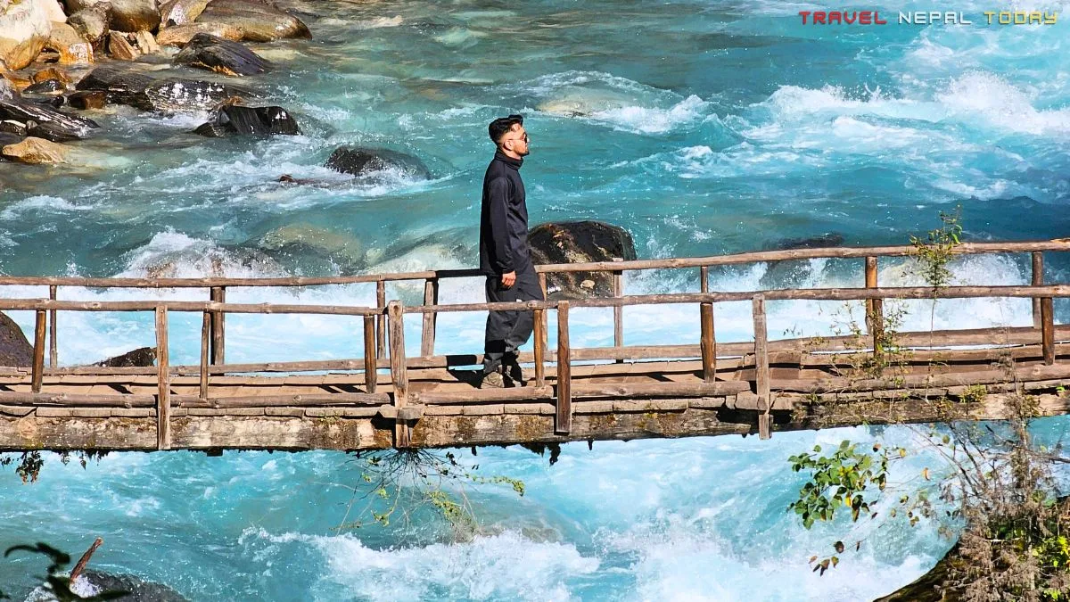
The photogenic wooden bridges start appearing around Kageni and continue all the way up.
At Sanduwa, Yulun Khola also merges in. These confluence points are where the river gets louder and the valley widens briefly.
The trail from Polam to the Phoksundo waterfall viewpoint is the steepest and most demanding section of the entire trek.
We were warned that it was a steep climb where your nose touches the hill. I used that line on my friends to give them the psychological boost they needed.
Was it that steep? Yes, actually. Not impossibly so, but it’s the one section where you’ll feel the most difficult.
Arriving at Ringmo after this climb, with the first glimpse of the lake appearing through the trees, is the reward. That turquoise color appearing between pine branches is the reason this trek exists!
Best Phoksundo Lake Trek Itineraries
The actual trekking days from Suligad to Ringmo and back are 4 to 6 days. Everything around them depends on how you travel to Dolpa.
I personally recommend 8 to 9 days minimum via the road. 7 days is only realistic if you’re flying. Here’s every option in detail:
Itinerary #1: 7-Day Trek via Flight Only
This is the fastest option and genuinely comfortable if flights work in your favor.
Day 1: Kathmandu to Nepalgunj or Surkhet (Flight), Explore and Stay
| Flight Duration | 55 minutes (Kathmandu to Nepalgunj) / 60 minutes (Kathmandu to Surkhet) |
| Purpose | Overnight here for next morning connection flight to Juphal |
| Difficulty | Easy |
Day 2: Nepalgunj/Surkhet to Juphal (Flight), Drive to Suligad, Trek to Chhepka
| Flight Duration | 45 minutes (Nepalgunj to Juphal) / 40 minutes (Surkhet to Juphal) |
| Juphal to Suligad Drive | 6.5 km, 30 minutes by jeep or 2 hours walk |
| Trek: Suligad to Chhepka | 13.5 km, 7 to 8 hours |
| Elevation Gain | 700 m approx. |
| Route | Suligad (2,060 m) > Kageni (2,320 m) > Raktan (2,270 m) > Shyagda (2,480 m) > Chhepka (2,760 m) |
| Difficulty | Moderate (long day) |
Note: Depending on flight time and vehicle availability, you may only reach Kageni. That is fine. Adjust Day 3 accordingly.
Day 3: Chhepka to Chunuwar
| Start Point | Chhepka (2,760 m) |
| End Point | Chunuwar / Jharana Hotel (3,155 m) |
| Distance | 14 km |
| Duration | 6 to 7 hours |
| Elevation Gain | 395 m |
| Route | Chhepka > Renchi (3,120 m) > Sanduwa (3,110 m) > Bagral (3,100 m) > Saaijol (3,130 m) > Chunuwar (3,155 m) |
| Difficulty | Easy |
Day 4: Chunuwar to Ringmo, Explore Phoksundo Lake and Monastery Visit
| Start Point | Chunuwar (3,155 m) |
| End Point | Ringmo (3,640 m) |
| Distance | 8 km |
| Duration | 5 to 6 hours |
| Elevation Gain | 485 m |
| Route | Chunuwar > Polam (3,265 m) > Phoksundo Waterfall Viewpoint (3,748 m) > Ringmo (3,640 m) |
| Difficulty | Moderate |
Day 5: Phoksundo Viewpoints, Descend to Renchi
| Morning | Hike to Phoksundo viewpoints (3.5 km, 4 hours round trip, up to 4,045 m) |
| Afternoon | Descend from Ringmo to Renchi |
| Descent Distance | 17 km |
| Descent Duration | 5 to 6 hours |
| Difficulty | Moderate |
Day 6: Renchi to Suligad, Drive to Juphal
| Start Point | Renchi (3,120 m) |
| End Point | Juphal (2,475 m) |
| Trek: Renchi to Suligad | 11.5 km, 5 to 6 hours |
| Drive: Suligad to Juphal | 6.5 km, 30 minutes |
| Difficulty | Easy |
Day 7: Juphal to Nepalgunj (Flight), Return to Kathmandu (Flight)
| Flight: Juphal to Nepalgunj | 45 minutes |
| Flight: Nepalgunj to Kathmandu | 55 minutes |
| Note | Allow weather buffer; flights can delay |
Itinerary #2: 7-Day Trek via Flight and Road
For those who want to fly into Dolpa but return by road, or vice versa. This works better for those with a flexible schedule and who don’t mind the long return bus journey.
- Day 1: Kathmandu to Nepalgunj/Surkhet flight, Drive to Suligad
- Day 2: Reach Suligad, Trek to Chhepka
- Day 3: Chhepka to Ringmo, Explore Phoksundo Lake
- Day 4: Reach Phoksundo Viewpoints, Return to Renchi
- Day 5: Renchito Dunai
- Day 6: Drive to Nepalgunj/Surkhet
- Day 7: Nepalgunj/Surkhet to Kathmandu flight
Itinerary #3: 8-Day Trek via Road (My Itinerary)
This is what my team did, and it works well. I’ve attached links to different parts of my stories (if you’ve got time, do read them)
Day 1: Board Kathmandu to Dunai Bus
| Start Point | Kathmandu Bus Park |
| End Point | Kageni (2,320 m) |
| Departure Time | 11 AM (usually) |
| Drive Duration | 30 hours approx. |
| Drive Distance | 630 km approx. |
| Difficulty | Moderate |
Day 2: Reach Suligad, Trek to Kageni
| Start Point | Suligad (2,060 m) |
| End Point | Kageni (2,320 m) |
| Trek Distance | 5.5 km |
| Duration | 3 hours |
| Elevation Gain | 260 m |
| Difficulty | Easy |
Day 3: Kageni to Saaijol
| Start Point | Kageni (2,320 m) |
| End Point | Saaijol / Chunuwar (3,130 to 3,155 m) |
| Distance | ~17 km |
| Duration | 7 to 8 hours |
| Elevation Gain | ~835 m |
| Route | Kageni > Raktan > Shyagda > Chhepka (lunch) > Renchi > Sanduwa > Bagral > Saaijol > Chunuwar |
| Difficulty | Easy |
Day 4: Saaijol to Ringmo, Explore Lake and Monastery
| Distance | 8 km |
| Duration | 5 to 6 hours |
| Elevation Gain | 510 m |
| Route | Saaijol > Chunuwar > Polam (3,265 m) > Phoksundo Waterfall Viewpoint (3,748 m) > Ringmo (3,640 m) |
| Difficulty | Moderate |
Day 5: Phoksundo Viewpoints, Descend to Renchi
| Morning | Viewpoint hike (3.5 km round trip, start by 6 AM, reach 4,045 m) |
| Afternoon | Descend Ringmo to Renchi (~17 km, 5 to 6 hours) |
| Difficulty | Moderate |
Day 6: Renchi to Dunai, Explore Dunai
| Start Point | Renchi (3,120 m) |
| End Point | Dunai (2,150 m) |
| Trek: Renchi to Suligad | 11.5 km, 5 to 6 hours |
| Jeep: Suligad to Dunai | NPR 100 per person if shared, or walk 30 minutes |
| Difficulty | Easy |
Tip: Pre-book your return bus ticket from Dunai the moment you arrive and have network. There is only one direct bus per day.
Day 7: Board Dunai to Kathmandu Bus
| Departure | 11 AM from Dunai |
| Route | Same highway in reverse |
| Drive Duration | 30 to 35 hours |
Note: Fare from Dolpa to Kathmandu tends to be slightly cheaper. Get tickets from a local agent in Dunai rather than pre-booking from Kathmandu.
Day 8: Reach Kathmandu
| Arrival | Mid-afternoon to evening, depending on road conditions |
| Major Stops | Musikot (dinner), Burtibang (breakfast), Lumle (lunch) |
Itinerary 4: 9-Day Trek via Road (Recommended)
This is similar to the 8-day version, but one extra day as a rest in Dunai for a more comfortable experience:
- Day 1: Board Kathmandu to Dunai Bus
- Day 2: Reach Dunai, Rest
- Day 3: Dunai to Suligad drive, Trek to Chhepka
- Day 4: Chhepka to Chunuwar
- Day 5: Chunuwar to Ringmo, Phoksundo Lake Explore and Monastery Visit
- Day 6: Get to Phoksundo Viewpoints, Descend to Renchi
- Day 7: Renchi to Dunai
- Day 8: Board Dunai to Kathmandu bus
- Day 9: Reach Kathmandu
Itinerary 5: 10-Day Trek via Road (Most Relaxed)
For those who want an extra night in Ringmo, this is what I’d actually recommend if you can afford the days.
One full day at Phoksundo without having to rush to the viewpoints and descend the same day is a completely different experience:
- Day 1: Board Kathmandu to Dunai bus
- Day 2: Reach Dunai
- Day 3: Dunai to Suligad drive, Trek to Chhepka
- Day 4: Chhepka to Chunuwar
- Day 5: Chunuwar to Ringmo, Explore Lake and Monastery
- Day 6: Extra Day in Ringmo, Full viewpoint Experience, Reach other side of the lake
- Day 7: Ringmo to Chhepka
- Day 8: Chhepka to Dunai
- Day 9: Board Dunai to Kathmandu Bus Day
- 10: Reach Kathmandu
Note: More itineraries covering Upper Dolpo extensions and longer circuits will be added here on Travel Nepal Today soon. If you need a specific combination, drop a comment below and I’ll update the article accordingly.
Difficulty Level of the Phoksundo Lake Trek
Let me be direct about this: the trek itself is easy to moderate. So, beginners can definitely do this!
The hardest part of the entire Phoksundo Lake experience is not the hike. It’s actually the bus journey (if you choose this).
A 30-hour bus ride on mountain roads through Rukum, Jajarkot, and Dolpa is physically demanding in a different way from hiking. Your back will protest. Your neck will stiffen.
The road surfaces range from decent blacktop to rough earthen stretches that throw the bus around. The compensating factor is that the scenery throughout is genuinely beautiful, particularly from West Rukum onward into Dolpa.
If you’re flying, the challenge shifts to Juphal airport: one of Nepal’s most technical domestic airstrips, with a short runway on a hillside at 2,475 m.
Weather cancellations are common and flight schedules can shift by a full day without warning!
On the trail itself:
- The sections from Suligad to Renchi are mostly flat to gradual. Easy walking!
- The river trail is well-defined, wooden bridges break up the monotony, and settlements are regular enough that you’re never far from a teahouse.
- The steepest section is from Polam to the Phoksundo waterfall viewpoint. This is the one stretch where even fit trekkers will feel the burn. From there, it’s a slight descent to Ringmo.
- The viewpoint hike above Ringmo is steeper than the main trail, but it’s short. 3.5 km one way. You’ll gain around 400 m elevation from Ringmo. Start early and take your time!
- Monsoon and post-monsoon landslides. The section near Kageni is explicitly landslide-prone. We crossed it in the afternoon when the wind was strong and rocks were actively falling! In monsoon and post-monsoon conditions, this section can be genuinely dangerous.
IMPORTANT: If you’re doing this trek in July, August, September, and even early October, please check trail conditions before starting and cross this section in the morning when it’s calmer
Risk of altitude sickness is low but not zero. The highest sleeping point is around 3,640 m in Ringmo.
But do note that AMS can begin showing symptoms from 2,000 m onward (source). If you feel persistent headache, unusual fatigue, or nausea at altitude, descend and rest. The standard rule applies: go up slow, come down fast.
Best Time for the Phoksundo Lake Trek
Every month is technically possible for the Phoksundo Lake Trek. But your experience will be completely different depending on when you go, and some windows are genuinely better than others.
Here’s the honest take before we get into the breakdown:
- Spring (March to April) and autumn (October to mid-November) are the peak seasons. Better views, more stable weather, more predictable conditions. But peak season also means peak crowd, and on a remote trail like Phoksundo, even a moderate increase in trekkers changes the feel of the whole thing.
- If you want the best of both worlds: good conditions without the crowd, summer (May, early June) and pre-winter (late November, December) are genuinely underrated.
Well, choosing a season isn’t enough on its own. No matter which month you go, rainfall or snowfall can hit when you’re not expecting it. And note that conditions change fast in Dolpa!
What I personally do before any trek is check Zoom Earth about 2 to 3 days before departure to look at precipitation probability in the specific region.
I’ll be covering more weather tools in a dedicated article here on TNT, but start with that one. Real-time checks beat calendar assumptions every time!
Now, let me walk you through each season properly:
Spring or ‘Basanta’ (March and April)
| Avg Daytime Temp (°C) | 4°C to 8°C |
| Avg Nighttime Temp (°C) | -10°C to -5°C |
| Snowfall Probability | Moderate (residual snow on passes) |
| Rainfall Probability | Low (approx. 6 days per month) |
| Sky Condition | Clear / Deep Blue |
| Visibility | High (Sharp peaks) |
| Trail Condition | Melting snow / Some icy patches |
| Frozen Ground Risk | High (Mornings) |
| Weather Stability | Very Stable |
Summer or ‘Basanta’ (May and June)
| Factor | May | June |
| Avg Daytime Temp (°C) | 10 to 14°C | 13 to 16°C |
| Avg Nighttime Temp (°C) | $-5$ to $0$°C | 0 to 5°C |
| Snowfall Probability | Very Low | None |
| Rainfall Probability | Moderate (9 days) | High (15 days) |
| Sky Condition | Partly Cloudy | Cloudy / Hazy |
| Visibility | Good | Medium |
| Trail Condition | Dry / Firm | Damp / Some mud |
| Frozen Ground Risk | Low | None |
| Weather Stability | Moderate | Unstable |
Monsoon or ‘Barsha’ (July to September)
| Factor | July – August | September |
| Avg Daytime Temp (°C) | 14 to 18°C | 10 to 14°C |
| Avg Nighttime Temp (°C) | 5 to 10°C | 2 to 6°C |
| Rainfall Probability | Highest (21 days) | Moderate (15 days) |
| Snowfall Probability | None | Rare (High peaks) |
| Sky Condition | Overcast / Foggy | Clearing / Blue patches |
| Visibility | Low | Improving |
| Trail Condition | Muddy / Landslide risk | Drying / Firm |
| Frozen Ground Risk | None | Low |
| Weather Stability | Very Unstable | Improving |
Autumn or ‘Sharad’ (October to Mid-November)
| Factor | October | Mid-November |
| Avg Daytime Temp (°C) | 8 to 12°C | 4 to 7°C |
| Avg Nighttime Temp (°C) | -3 to 2°C | -8 to -3°C |
| Rainfall Probability | Low (4 days) | Minimal (2 days) |
| Snowfall Probability | Low | Low–Medium |
| Sky Condition | Crystal Clear | Very Clear |
| Visibility | Unrivaled (Maximum) | Excellent |
| Trail Condition | Perfectly Dry | Frozen in mornings |
| Frozen Ground Risk | Medium | High |
| Weather Stability | Very Stable | Stable |
Pre-Winter or ‘Sishir’ (Late November to December)
| Factor | Late Nov – Early Dec | Late December |
| Avg Daytime Temp (°C) | 2 to 5°C | -2 to 2°C |
| Avg Nighttime Temp (°C) | -12 to -8°C | -16 to -12°C |
| Snowfall Probability | Medium | High |
| Rainfall Probability | Minimal | Low (Mostly snow) |
| Sky Condition | Clear / Bright | Clear / Hazy |
| Visibility | High | High (Dry air) |
| Trail Condition | Hard / Frozen | Snow-covered |
| Frozen Ground Risk | Very High | Permanent (Seasonal) |
| Weather Stability | Stable | Stable (but Extreme) |
Winter or ‘Hemanta’ (January to February)
| Factor | January | February |
| Avg Daytime Temp (°C) | -4 to 1°C | -2 to 2°C |
| Avg Nighttime Temp (°C) | -20 to -15°C | -18 to -14°C |
| Snowfall Probability | Very High | Very High |
| Rainfall Probability | Low (5 days) | Low (6 days) |
| Sky Condition | Clear or Snowing | Mostly Cloudy |
| Visibility | Variable | Low (Blizzards) |
| Trail Condition | Deep Snow / Blocked | Deep Snow / Icy |
| Frozen Ground Risk | Permanent | Permanent |
| Weather Stability | Unpredictable | Unpredictable |
A note on season creep:
Nepal’s seasons are shifting. Monsoon has been extending up to early October. Spring arrives warmer earlier!
This has been directly affecting both road conditions and trail accessibility across the country. So, always check recent traveler reports and local updates before finalizing your dates rather than relying on month-by-month guides alone.
What Permits Do You Need for the Phoksundo Lake Trek?
This is another area with confusing information online. Let me set it straight. Two permits are required, and one is optional:
Shey Phoksundo National Park Entry Permit
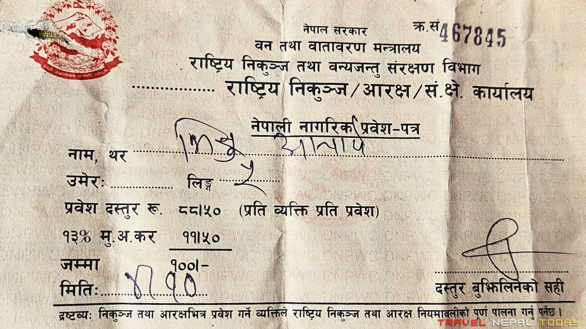
| Nepali Citizens | NPR 100 |
| SAARC Nationals | NPR 1,500 |
| Foreign Nationals | NPR 3,000 |
This can be obtained at the Suligad checkpost on the trail, or arranged in advance through your trekking agency.
Lower Dolpo Restricted Area Permit (RAP)
The Phoksundo Lake trek falls within a restricted area, as Shey-Phoksundo Rural Municipality wards 8 and 9 are officially restricted zones.
| Cost | USD 20 per person per week (first 4 weeks), then USD 5 per additional week |
| Who needs it | Foreign nationals only (not applicable to Nepalese trekkers) |
| How to get it | Through a registered trekking agency only. You cannot apply independently. |
| Minimum group | Previously required group of 2+. As of recent updates, solo foreign trekkers can obtain the permit but a licensed guide is still compulsory. |
This restricted area requirement is the main reason the Phoksundo Lake Trek is more expensive for foreign nationals.
The permit must be processed through a registered agency, which means guide fees and agency costs are also part of the foreign trekker’s budget.
What this also means is you need to have a TRAVEL INSURANCE! Not just you, even those travelling with you must be insured (including guides, porters, assistants, etc.). This is the policy of restricted areas in Nepal.
TIMS Card (Optional)
TIMS is not strictly enforced on the Phoksundo Lake Trek route at this point. However, if you’re going through an agency, they will typically handle TIMS as part of the package.
What happens if you enter without the correct permits? Well, national park fines will apply (can be hefty)! And since this is a restricted area, you will be turned back immediately from checkpoints (in Suligad, Chhekpa, and Ringmo) as there’s no other option to get through.
Cost Breakdown for Phoksundo Lake Trek
For foreign trekkers, prices vary significantly by agency. Budget agencies operating from within Nepal will charge considerably less than international operators.
If you’re having difficulty finding a reliable agency, reach out to us at TNT and we’ll point you in the right direction.
I completed this trek with three friends in October 2024 under NPR 25,000 per person. That included: bus fare both ways, national park entry, all accommodation and meals on the trail, snacks and medicines, and the Dolpa apple crate on the way back.
We were on a budget, which meant: only two meals a day (no three-meal days), no alcohol on the trail, minimal extra spending, and relying heavily on snacks we carried from Kathmandu.
This approach is not recommended for first-time trekkers. Skipping a meal at altitude when you’re hiking 7 to 8 hours is a bad idea unless you know exactly how your body responds.
For Nepalese, Phoksundo Trek can cost you NPR 30,000 to 35,000 (depending on transport and spending habits). That’s the ideal expenditure. But if you’re doing like us, it’s possible within NPR 20,000 to 25,000 too.
Here is a general reference table for both Nepalese and foreign trekkers:
| Cost Component | Nepalese | Foreign (Agency-Based) |
| Transportation fare (twto-way) | NPR 10,000 to 12,000 | Included in package or USD 30 to 80 |
| National Park Permit | NPR 100 | NPR 3,000 |
| Restricted Area Permit | Not required | USD 20 per week |
| Accommodation (per night) | NPR 400 to 800 | Included in package or USD 4 to 10 |
| Food (per day) | NPR 800 to 1,500 | Included or USD 10 to 20 |
| Guide (if hired) | Optional | USD 20 to 50 per day (compulsory for foreigners, guide’s salary depends on experience and you also need to provide tips) |
| Miscellaneous/snacks | NPR 1,000 to 2,000 | USD 20 to 50 |
| Total Estimate | NPR 25,000 to 40,000 | USD 400 to 1,000 (agency-based package) |
Food, Water, and Accommodation on the Trail
This is one part of the trek where your expectations need to adjust a little, but once you do, it actually becomes part of the experience. Nothing here is luxurious, but everything you need is available in its own simple, functional way.
Accommodation
Teahouses are available at: Kageni, Chhepka, Renchi, Sanduwa, Bagral (Samjhana Hotel), Saaijol (Tapriza), Chunuwar (Jharana Hotel), and Ringmo.
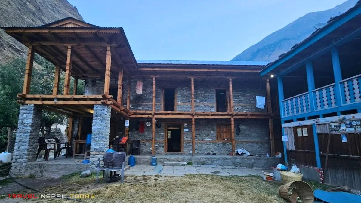
Don’t arrive with luxury expectations! The rooms are simple with:
- In flat-roofed Dolpo-style buildings.
- Thin mattresses.
- Blankets that range from adequate to questionable.
- Squat toilets that, in Ringmo at least, have a window with a view of Phoksundo Lake that makes up for every other shortcoming!
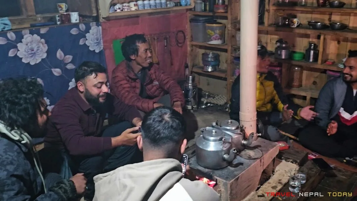
Our hotel in Ringmo didn’t have soap. The pillow was a sack with something inside. I asked the hotel owner for an extra pillow, and he brought a sack stuffed with rice or grain. This is not a complaint. This is the Phoksundo experience, and it’s genuinely something to appreciate once you adjust your expectations!
What I’ll say is that the hospitality and warmth from every teahouse owner along this route was completely real. They welcome you into their homes, they cook for you, and they share their space genuinely.
During peak season (October, November, March, April), I advise pre-booking, particularly in Ringmo. In off-season, you’ll have no issues!
Electricity and charging are generally available throughout the route, though solar-powered and weather-dependent at higher sections. Carry a power bank regardless.
Stargazing in Dolpa is extraordinary. Clear nights at Ringmo are one of those experiences you don’t anticipate until it’s happening.
Food
Dal Bhat is the main fuel on this trail, as it is everywhere in Nepal. It’s nutritious, filling, and the most practical thing to order for sustained energy during long hiking days. “Dal Bhat power, 24 hour” is not just a saying here!
For breakfast, you’ll be offered tea, chapati, oatmeal, eggs, and noodle soup at most places.
Yak Sukuti is available in Ringmo and is worth trying (not too much, just a little for taste).
We even tried the meat of Chyangra (Himalayan Goat), Bhang ko Achaar (Hemp Seed Pickle), and local apples I mentioned earlier.
At altitude, heavy or unfamiliar foods slow you down and can upset your digestion. So, avoid heavy meats in the middle of the trail. Without refrigeration, meat safety becomes questionable. Trust Dal Bhat with veggies like we all Nepalese do!
Drinking Water
Boiled water is available at all teahouses. Fill your bottles from the teahouse supply rather than directly from streams unless you have purification tablets or a filter.
Carry purification tablets as a backup regardless. At higher sections near Ringmo, the water comes from glacial sources and is generally clean but still worth treating before drinking.
Hydration is more important than you think at these altitudes. Aim for 3 to 4 litres per day, even when you don’t feel thirsty.
Mobile Network Coverage
NTC (Nepal Telecom) works reasonably well from Bagral onward and into Dunai. Below Saaijol, particularly in the lower forested gorge sections, the signal drops out almost entirely ( on the forest routes).
There is a famous tree near Raju Hotel in Kageni where, mysteriously, a network signal appears. Our group genuinely took turns climbing it to check messages. This sounds like a joke but it is completely true!
Ncell towers are less reliable on this route. NTC is the safer option!
Packing List for the Phoksundo Lake Trek
We went in October, and my packing was practical but not perfect. Here’s what I’d recommend based on experience.
- Clothing:
- Moisture-wicking trekking t-shirts (2 is enough)
- Trekking pants (1 to 2 depending on season, one can be shorts in summer)
- A down jacket for evenings and mornings
- A windcheater outer layer, sunhat
- A fleece as a mid-layer
- Woolen cap, neck gaiter, gloves (winter or cold weather essential, spring optional)
- A sleeping set (comfortable trouser and sweatshirt for lodge nights).
- Inner wears (one for each day)
- Footwear:
- Broken-in trekking boots. This is non-negotiable. You’ll be in remote terrain for 5 to 6 days. A boot that hasn’t been broken in will give you blisters that affect your entire trip.
- 4 to 5 pairs of trekking socks, preferably merino wool.
- Camp sandals for lodge use.
- Gear:
- 60 to 70 litre trekking bag
- A small daypack for Phoksundo Viewpoint day hike
- Water bottle or thermos (2 if possible, otherwise 1 is also enough)
- Purification tablets (optional)
- Trekking poles (optional but useful on the Polam-Waterfall section)
- Power bank (fully charged before leaving Dunai)
- A rain poncho (regardless of the season/weather)
- Personal and Health:
- Sunscreen (UV exposure increases significantly at altitude and gets intensified by lake reflection at Ringmo)
- Sunglasses with UV protection (essential during snow conditions)
- Lip balm, basic toiletries, hand sanitizer, etc.
- Dry shampoo (optional)
- Quick-dry towel
- A first aid kit including pain relief, ORS packets, anti-diarrheal, any personal prescriptions, and bandages.
Responsible Trekking in Shey Phoksundo National Park
Shey-Phoksundo National Park has specific rules. These are from the official pamphlet issued at the Suligad entry point:
- Do not remove or damage any plants or animals. All flora and fauna are fully protected.
- Do not walk in the park between sunset and sunrise.
- Do not enter the national park without permits.
- All rubbish must be removed, buried, or placed in designated areas. Carry your non-biodegradable waste back out.
- Camping is only allowed in designated areas (with certain fees, so request your agency beforehand).
- Drone and documentary filming require separate permits from the Department of National Parks and Wildlife Conservation (DNPWC). The fee is USD 1,500 for foreign nationals, NPR 50,000 for SAARC nationals. An additional 25% applies for drone usage.
- Hunting is strictly prohibited.
- Also, do not disturb wildlife by playing speakers or producing to much noise.
- Swimming in Phoksundo Lake is not permitted. The lake is a protected Ramsar site and is sacred to the Bonpo community.
Final Thoughts
The Phoksundo Lake Trek doesn’t ask for the same things that most Himalayan treks ask for!
It doesn’t demand exceptional fitness. It doesn’t require technical skills. What it does ask for is patience, a genuine curiosity about the world you’re walking into, and the willingness to be a little bit uncomfortable for most of the journey to the lake.
Standing at the lakeshore at Ringmo, watching the Phoksundo Lake’s color shift from charcoal to turquoise as the morning light hit the water is surely one of the best things to experience in Nepal!
If you’re planning this trek and have questions that this guide hasn’t answered, drop them in the comments. I read every one, and I’ve already answered a few of them on this blog. I’ll update this guide regularly as conditions and information change!
Happy travelling to Dolpa!
Quick Answers
When was the Phoksundo Lake Trek opened to tourists?
The Dolpo region, including Phoksundo Lake, was officially opened to foreign tourists in 1989. Before that, the entire area was closed to outsiders, and access was strictly limited.
Even after opening, the restricted area permit system was put in place to control the number of visitors and preserve the fragile culture and ecosystem of the region. This is one of the reasons Phoksundo still feels genuinely remote compared to more accessible Nepali trekking destinations.
Is the Phoksundo Lake Trek suitable for beginners?
Yes, with some honesty attached to that answer.
The trek itself is easy to moderate. The trail is mostly flat to gradual, follows a river the entire way, and doesn't involve any technical climbing or passes. From a pure hiking standpoint, a reasonably fit beginner can complete it.
What makes this trek more challenging for beginners is everything around the trek. The 30-hour bus, two flights, or the flight with road journey, each one is physically demanding in a different way from hiking. The remote setting means there are no quick exits if something goes wrong.
If you're a beginner, go in a group, choose a longer itinerary (9 to 10 days), and don't skip the agency or guide option. While the trek is accessible, the environment around it demands more preparation than the trail itself.
Is altitude sickness a real risk on the Phoksundo Lake Trek?
The risk is low but not zero, and it's worth taking seriously.
The highest sleeping altitude on this trek is Ringmo at approximately 3,640 m. Still, AMS (Acute Mountain Sickness) can begin showing symptoms from as low as 2,000 m onward, particularly in people who gain altitude quickly without acclimatization.
On the Phoksundo route, the ascent from Suligad to Ringmo is gradual enough that your body generally has time to adjust.
The standard rules apply: go up slow, come down fast. If you develop a persistent headache, unusual fatigue, or nausea above 3,000 m, descend and rest. Don't wait to see how bad it gets.
Diamox (acetazolamide) is available as a preventive option, but consult your doctor before taking it. Staying well-hydrated throughout the trek is the most practical and accessible preventive measure.
Is there any difference between Lower Dolpo and Upper Dolpo, and which one does the Phoksundo Lake Trek cover?
The Phoksundo Lake Trek is in the Lower Dolpo region. The trek goes from Suligad to Ringmo village on the southern shore of Phoksundo Lake. Everything within this route is in the Lower Dolpo region.
Upper Dolpo begins beyond Phoksundo Lake, heading north toward Shey Gompa and toward the Tibetan plateau. Upper Dolpo requires a separate and significantly more expensive restricted area permit, currently USD 500 per person for 10 days. It also requires more technical preparation, a longer itinerary, and a registered agency.
The viewpoint trail above Ringmo does point in the direction of Upper Dolpo, and the same trail eventually leads to Shey Monastery if you continue. But the Phoksundo Lake Trek as a standard itinerary stops at Ringmo and does not cross into Upper Dolpo.
Can you reach Phoksundo Waterfall from the main trail?
The Phoksundo waterfall, sometimes called the Suligad Waterfall, is formed by the overflow of Phoksundo Lake dropping approximately 167 meters down a cliff face. It is one of the highest waterfalls in the Dolpo region!
You cannot directly access the base of the waterfall from the main trail. The viewpoint from which most trekkers see it is on the ascent from Polam towards Ringmo, at approximately 3,748 m. From this point, the waterfall appears dramatically across the valley with the lake above it.
On the right day, with the right angle of light, you can see rainbows forming at the base of the falls. Our group spent the better part of an hour at this viewpoint. I genuinely regret not having a better camera at that moment.
Can you extend the Phoksundo Lake Trek into Upper Dolpo or Shey Gompa?
Yes, and it's one of the more rewarding extensions possible from Ringmo.
From Ringmo, the viewpoint trail continues northward toward Phoksundo Pass (approximately 5,000 m), and from there into Upper Dolpo toward Shey Gompa and the Crystal Mountain. This extension adds 7 to 12 days to the trip depending on your route and pace.
However, extending into Upper Dolpo requires the Upper Dolpo restricted area permit (USD 500 per 10 days) and significantly more preparation. The terrain is more demanding and remote than the Lower Dolpo route!
If you're planning this extension, it needs to be arranged through a registered trekking agency before you start the trek. You cannot simply decide to continue north at Ringmo without the correct permit already in hand.
What is the Juphal airport, and how reliable are flights there?
Juphal airport (IATA: TPJ) sits at 2,475 m in the hills above Dunai, the headquarters of Dolpa district. It is one of Nepal's most challenging domestic airstrips: short runway, one-sided approach, and heavily dependent on weather conditions.
Flights operate on small Twin Otter aircraft, primarily through Tara Air and Simrik Air. Cancellations are common, particularly in the afternoon when mountain winds pick up. If your flight is scheduled for the afternoon, expect delays or possible cancellation.
The practical implication: always build at least one buffer day on either side of your Juphal flight. Arrive in Nepalgunj or Surkhet the day before your planned Juphal departure. On the return, don't book a connecting international flight from Kathmandu on the same day as your Nepalgunj arrival. Things can cascade quickly when a mountain airport is involved.
How is the Phoksundo Lake Trek different from the Rara Lake Trek?
Both Rara and Phoksundo are remote high-altitude lakes in the Karnali province of Nepal, and the comparison comes up often. Here's how they actually differ:
- Rara Lake (2,990 m) is in the Mugu district and sits lower in altitude, making it more accessible for beginners. It's within the Rara National Park and is Nepal's largest lake by surface area. The trek to Rara is generally shorter and the cultural landscape around it is different, dominated by hill communities rather than Tibetan Bon culture.
- Phoksundo Lake (3,611 m) is deeper, higher, more turquoise, and culturally richer in terms of the Bonpo tradition. The trek is longer and the journey to get there is significantly more demanding, whether by road or flight. The remoteness is a different category.
If you want an accessible western Nepal lake trek, Rara is the choice. But if you want something that genuinely challenges you to earn the destination, Phoksundo is in a different league.


Do you know if you can do this trek solo or if I have to have a guide, thanks
Hello there, Mltch!
Solo treks are not permitted in Shey-Phoksundo National Park. However, you can trek with a friend or partner, or if you’re alone, you can hire a local guide. Please note that a trekking permit is also required for entry. If you’d like more information, feel free to email me at bhishu@travelnepaltoday.com. I’d be happy to assist you further!
Hey. Can we complete this trek in Mid-March? Is the weather ok there in that time? Also, is the trail safe for girls?
Hey Durga!
Mid-March is usually a great time for the Phoksundo trek, with blooming rhododendrons and pleasant weather. But this year, the weather has taken a bit of a turn—it’s colder and a bit unpredictable compared to usual. So if you’re aiming for a more comfortable experience, it might be better to delay the trek just a little until things settle.
That said, the trail itself is beautiful around this time, and once the weather clears up, it’ll be totally worth it.
As for safety—yes, the trail is safe for girls. Many have even done it solo without any issues. But if you’re planning to travel by bus, just be a little cautious—sometimes unexpected things can happen. I’ve shared a similar experience here.
Let me know if you need help with anything else!
Good Information with detailed cost but is taking guide a must and how much for the trekking permit after paying entry fee
Hi Shadirar,
You’ll need the following trekking permits for Phoksundo Lake, which is in the Lower Dolpo region:
Trekking permits can be a hassle. However, as per the Shey Phoksundo Entrance Card, you can obtain them directly in Suligad. Many travelers prefer using a reliable travel agency to handle these formalities, though agencies typically charge extra for their services.
Let me know if you’d like me to find a reliable travel agency for you. And if you’re planning to trek solo, you’ll need to have a local guide at the very least. However, if you’re traveling with your own group, there’s no mandatory guide requirement in the Lower Dolpo region.
Hopefully, this answers all your queries. Feel free to reach out if you need any more details—always happy to help!
P.S. I understand this guide is primarily focused on local travelers. I’ll soon publish a dedicated guide covering everything—from permits and budget-friendly trekking packages to other essential details—right here on this site. Stay tuned!
Hey is June month is fine to trek and is it allowed to do solo trek ?
Hello Rakesh,
Early June is a wonderful time to visit Phoksundo Lake. Since the highlight of the trek is the tranquil beauty of the lake rather than distant mountain views, this period works really well. The monsoon hasn’t fully set in yet, so you can expect relatively dry trails but still the weather can be unpredictable. I wouldn’t recommend doing the trek once the monsoon hits. The road conditions, which are already challenging, tend to worsen significantly with rain. However, if you’re prepared for that, it’s still a rewarding destination. And yes…trekking solo is absolutely possible!
hey what is the cost of travel from nepalgunj to dunai are there any local transport available there and how long it takes from nepalgunj to dunai
Hey Anuj,
While I’m not exactly sure, but based on my research, the bus ticket price from Nepalgunj to Dolpa should be around Rs. 3,000–3,500 via Dolpa Shey-Phoksundo Yatayat.
Would this trek be possible in AUG? Also the total cost mentioned in the article here 20,550, is it NPR? Any way I could speed up the trip, I would like to get to those 3 viewpoints as fast as I can
Hello there, Devesh,
This trek is possible in August, but the monsoon has blocked some parts of the road after Tallu Bagar. This means you’ll need to find another jeep from that point, which can make the journey a bit more time-consuming. Also, please note that the total cost mentioned in the article is for Nepalese citizens—if you’re from outside Nepal, the cost will be slightly higher.
Even if you try to speed things up, it will be difficult to return to Kathmandu the same day, as the only direct bus departs at 11 AM daily (yes, there’s only one).
From my experience, the 8-day itinerary is not just the shortest but also the most optimal way to complete the Phoksundo trek. If you choose the flight option, it’s possible to finish it in 6–7 days, but that comes at a staggering cost!
You can book your tickets using this form. I highly recommend doing the trek after September. But if you’re planning to do it in August, it’s best to give yourself more time—around 10 days—since it’s prime monsoon season in Nepal, and safety should always be your top priority.
Hey, Being a Nepalese citizen, Am I allowed as solo trekker in December?
Hello Sudhir, yes! Nepalese citizens can trek solo. However, I’d still recommend going with at least one friend since it’s quite a remote area. December is a great time to go, but do check the weather conditions beforehand. All the best!
Hello Bhishu bhai,
Tapailai kastho chha ? Thank you for sharing all the relevant details. It is very helpful for planning. I am Prakash from India, a senior experienced trekker. Did EBC twice and AC solo and also ABC. Very keen to do Phoksundo lake trek. I can go in May 5th onwards or in November this year. Which would be the best? I guess apples are in October. As I am going solo can I expect to meet and join a group at Suligad or Dunai ? As a Saarc national permit and TIMS card can be taken at Suligad ? Can I stay more than a day at Ringmo ? Your suggestion for direct bus Kathmandu to Dunai sounds better and I may do that. But is it possible to reach Lucknow, Nepalganj by road and Dunai by road ? And while returning can I drop off at Pokhara itself ?
Another information I needed was if I can go from Pokhara to Manang and visit Tilicho lake Solo ? Have asked many questions . Hope you do not mind.
Dhanyavad
Hi Prakash ji,
Thank you for your detailed message, and it’s great to see your trekking experience—EBC twice and AC solo is impressive! Phoksundo will definitely be a unique experience compared to those regions.
Firstly, the Dolpo region is a restricted area, so you will need a Restricted Area Permit (RAP). This can only be processed through a registered trekking agency. Earlier, a minimum group of 2 was required, but now even solo trekkers can get the permit. However, a licensed guide is still compulsory.
Best Time to Visit
Both your timeframes are good:
May: More comfortable temperatures, greenery, and easier trekking conditions.
November: Clear skies and best mountain views, but it can get very cold, especially late November.
Solo Travel & Group Joining
Since permits are agency-based, you typically won’t just meet and join groups at Suligad or Dunai independently. However, many agencies organize group join treks. One option you can check is Altitude Himalaya (they operate Dolpo treks).
If you’re budget-conscious, you can also look for agencies that cater more to Indian trekkers.
Permits & TIMS
Your agency will arrange the RAP and other permits, so you don’t need to worry about getting them at Suligad.
TIMS is still recommended, although its role has become less strict recently.
Cost Insight
RAP costs around USD 500 for 10 days (Lower Dolpo)
After 10 days, it’s about USD 50 per day
(Upper Dolpo costs significantly more if you’re thinking to trek beyond Phoksundo)
Transport Options
Kathmandu → Dunai (bus): Budget-friendly, but long journey
Lucknow → Nepalgunj → Dunai: Yes, this is possible and actually quicker than coming via Kathmandu
From Nepalgunj, you can take a jeep or bus to Dunai
While returning, yes—you can drop off at Pokhara instead of Kathmandu. Many buses operate on this route.
Staying at Ringmo
Yes, you can absolutely stay more than a day at Ringmo. In fact, I’d recommend it—Phoksundo Lake and the village deserve proper exploration.
Tilicho Lake (from Pokhara / Manang)
Since you’ve already done the Annapurna Circuit solo, this will be familiar:
You only need the ACAP permit (from National Trust for Nature Conservation)
Solo trekking is allowed in this region!
From Manang, instead of heading to Yak Kharka, you can take a jeep to Khangsar and continue toward Tilicho.
Hope this helps!